Redbourn
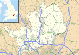
Redbourn is een civil parish in het bestuurlijke gebied St Albans, in het Engelse graafschap Hertfordshire. De plaats telt 6.000 inwoners.
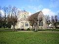 Kerk van St. Mary
Geplaatst op: 15-07-2007 |
Dit artikel is een beginnetje over landen & volken. U wordt uitgenodigd om op bewerken te klikken om uw kennis aan dit artikel toe te voegen. |
| Civil parish in Engeland | |||
 | |||
| Situering | |||
| Regio | East of England | ||
| Graafschap | Hertfordshire | ||
| District | St Albans | ||
| Coördinaten | 51° 48' NB, 0° 24' WL | ||
| Algemeen | |||
| Oppervlakte | 19,0857 km² | ||
| Inwoners (2011) | 5344 (280 inw./km²) | ||
| Overig | |||
| Postcode(s) | AL3 | ||
| Netnummer(s) | 01582 | ||
| Grid code | TL105125 | ||
| Post town | ST ALBANS | ||
| ONS-code | E04004806 | ||
| Foto's | |||
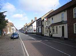 | |||
| Hoogstraat | |||
| |||
This article is issued from
Wikipedia.
The text is licensed under Creative
Commons - Attribution - Sharealike.
Additional terms may apply for the media files.