1883 eruption of Krakatoa
The 1883 eruption of Krakatoa (Indonesian: Letusan Krakatau 1883 ) in the Sunda Strait began on the afternoon of Sunday, 26 August 1883—with origins as early as that May—and peaked on the late morning of Monday, 27 August 1883, when over 70% of the island of Krakatoa and its surrounding archipelago were destroyed as it collapsed into a caldera.
| 1883 eruption of Krakatoa | |
|---|---|
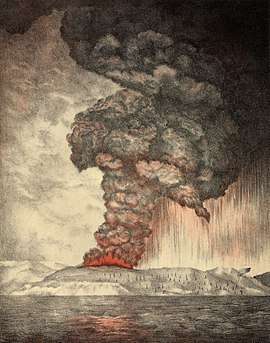 Lithograph of the eruption c. 1888 | |
| Volcano | Krakatoa |
| Start date | 26 August 1883 |
| End date | 27 August 1883 |
| Type | Ultra-Plinian |
| Location | Krakatoa archipelago, Sunda Strait |
| VEI | 6 |
| Impact | 20 million tons of sulfur released; five-year drop of 1.2 °C (2.2 °F) |
| Deaths | 36,417 |
 The change in geography after the eruption | |
The eruption was one of the deadliest and most destructive volcanic events in recorded history and explosions were so violent that they were heard 3,110 kilometres (1,930 mi) away in Perth, Western Australia, and Rodrigues near Mauritius, 4,800 kilometres (3,000 mi) away. At least 36,417 deaths are attributed to the eruption and the tsunamis it created.
Significant additional effects were also felt around the world in the days and weeks after the volcano's eruption. Additional seismic activity continued until February 1884; reports of seismic activity after October 1883 were later dismissed by Rogier Verbeek's investigation into the eruption.
Early phase
In the years before the 1883 eruption, seismic activity around the Krakatoa volcano was intense, with earthquakes felt as far away as Australia. Beginning on 19 May 1883, steam venting began to occur regularly from Perboewatan, the northernmost of the island's three cones. Eruptions of ash reached an estimated altitude of 6 km (20,000 ft) and explosions could be heard in New Batavia (Jakarta) 160 km (99 mi) away.[1]
Eruptions at Krakatoa started again around 16 June, with loud explosions and a thick black cloud covering the islands for five days. On 24 June, a prevailing east wind cleared the cloud, and two ash columns could be seen issuing from Krakatoa. The seat of the eruption is believed to have been a new vent or vents that formed between Perboewatan and Danan. The violence of the ongoing eruptions caused tides in the vicinity to be unusually high, and ships at anchor had to be moored with chains. Earthquakes were felt at Anyer, Banten, and ships began to report large pumice masses to the west in the Indian Ocean.[1]
In early August, a Dutch topographical engineer, Captain H. J. G. Ferzenaar, investigated the Krakatoa islands.[1] He noted three major ash columns (the newer from Danan), which obscured the western part of the island, and steam plumes from at least eleven other vents, mostly between Danan and Rakata. When he landed, he noted an ash layer about 0.5 m (1 ft 8 in) thick, and the destruction of all vegetation, leaving only tree stumps. He advised against any further landings.[1]
Climactic phase
By 25 August, the Krakatoa eruptions intensified. At about 1:00 pm on 26 August, the volcano went into its paroxysmal phase. By 2:00 pm, a black cloud of ash could be seen 27 kilometres high. At this point, the eruption was almost continuous and explosions could be heard every ten minutes or so. Ships within 20 km (12 mi) of the volcano reported heavy ash fall, with pieces of hot pumice up to 10 cm (4 in) in diameter landing on their decks. Between 7:00 pm and 8:00 pm, a small tsunami hit the shores of Java and Sumatra, 40 km (25 mi) away.
On 27 August, four enormous explosions occurred, which marked the climax of the eruption. At 5:30 am, the first explosion was at Perboewatan, triggering a tsunami heading to Telok Betong, now known as Bandar Lampung. At 6:44 am, Krakatoa exploded again at Danan, with the resulting tsunami propagating eastward and westward. The third and largest explosion, at 10:02 am, was so violent that it was heard 3,110 km (1,930 mi) away in Perth, Western Australia and the Indian Ocean island of Rodrigues near Mauritius, 4,800 km (3,000 mi) away, where the blast was thought to have been cannon fire from a nearby ship. The third explosion has been reported as the loudest sound heard in historic times.[2][3][4]:79 The loudness of the blast heard 160 km (100 mi) from the volcano has been calculated to have been 180 dB.[5] Each explosion was accompanied by tsunamis estimated to have been over 30 metres (98 feet) high in places. A large area of the Sunda Strait and places on the Sumatran coast were affected by pyroclastic flows from the volcano. The energy released from the explosion has been estimated to be equal to about 200 megatonnes of TNT (840 petajoules),[6] roughly four times as powerful as the Tsar Bomba, the most powerful thermonuclear weapon ever detonated. At 10:41 am, a landslide tore off half of Rakata volcano, along with the remainder of the island to the north of Rakata, causing the final explosion.[2]
Pressure wave
The pressure wave generated by the colossal third explosion radiated out from Krakatoa at 1,086 km/h (675 mph), 90% of the speed of sound. The eruption is estimated to have reached 310 dB, loud enough to be heard 5,000 kilometres (3,100 mi) away.[7]:248 It was so powerful that it ruptured the eardrums of sailors 64 km (40 miles) away on ships in the Sunda Strait,[7]:235 and caused a spike of more than 8.5 kilopascals (2.5 inHg) in pressure gauges 160 km (100 miles) away, attached to gasometers in the Batavia gasworks, sending them off the scale.[note 1]
The pressure wave was recorded on barographs all over the world. Several barographs recorded the wave seven times over the course of five days: four times with the wave travelling away from the volcano to its antipodal point, and three times travelling back to the volcano.[4]:63 Hence, the wave rounded the globe three and a half times. Ash was propelled to an estimated height of 80 km (50 mi).
The eruptions diminished rapidly after that point, and by the morning of 28 August, Krakatoa was silent. Small eruptions, mostly of mud, continued into October 1883. By then, less than 30% of the original island remained.
Effects


The combination of pyroclastic flows, volcanic ash, and tsunamis associated with the Krakatoa eruptions had disastrous regional consequences. Some land in Banten, approximately 90 km south, was never repopulated; it reverted to jungle and is now the Ujung Kulon National Park. The official death toll recorded by the Dutch authorities was 36,417.[8]
"The Burning Ashes of Ketimbang"
Verbeek and others believe that the final major Krakatoa eruption was a lateral blast, or pyroclastic surge. Around noon on 27 August 1883, a rain of hot ash fell around Ketimbang (now Katibung in Lampung Province) in Sumatra. Approximately 1,000 people were killed in Sumatra;[7] there were no survivors from the 3,000 people on the island of Sebesi. There are numerous reports of groups of human skeletons floating across the Indian Ocean on rafts of volcanic pumice and washing up on the east coast of Africa, up to a year after the eruption.[7]:297–298
Tsunamis and distant effects
Ships as far away as South Africa rocked as tsunamis hit them, and the bodies of victims were found floating in the ocean for months after the event. The tsunamis which accompanied the eruption were believed to have been caused by gigantic pyroclastic flows entering the sea; each of the four great explosions was accompanied by large pyroclastic flows resulting from the gravitational collapse of the eruption columns. This caused several cubic kilometres of material to enter the sea, displacing an equal volume of seawater. The town of Merak was destroyed by a tsunami which was 46 metres high. Some of the pyroclastic flows reached the Sumatran coast as much as 40 km (25 mi) away, having apparently moved across the water on a cushion of superheated steam.[note 2] There are also indications of submarine pyroclastic flows reaching 15 km (9.3 mi) from the volcano.[9]
Smaller waves were recorded on tidal gauges as far away as the English Channel.[10] These occurred too soon to be remnants of the initial tsunamis and may have been caused by concussive air waves from the eruption. These air waves circled the globe several times and were still detectable on barographs five days later.[11]
Geographic effects
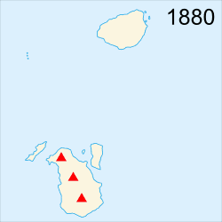
In the aftermath of the eruption, it was found that Krakatoa had almost entirely disappeared, except for the southern third. The Rakata cone was cut off along a vertical cliff, leaving behind a 250-metre (820 ft) cliff. Of the northern two-thirds of the island, only a rocky islet named Bootsmansrots ('Bosun's Rock'), a fragment of Danan, was left; Poolsche Hoed had totally disappeared.
The huge amount of material deposited by the volcano drastically altered the surrounding ocean floor. It is estimated that as much as 18–21 km3 (4.3–5.0 cu mi) of ignimbrite were deposited over 1,100,000 km2 (420,000 sq mi), largely filling the 30–40 m (98–131 ft) deep basin around the mountain. The land masses of Verlaten and Lang islands were increased, as was the western part of the remnant of Rakata. Much of this gained material quickly eroded away, but volcanic ash continues to be a significant part of the geological composition of these islands. The basin was 100 m (330 ft) deep before the eruption, and 200–300 m (660–980 ft) after.[12]
Two nearby sandbanks (called Steers and Calmeyer after the two naval officers who investigated them) were built up into islands by ashfall, but the sea later washed them away. Seawater on hot volcanic deposits on Steers and Calmeyer had caused steam to rise, which some mistook for a continued eruption.
Global climate
In the year following the eruption, average Northern Hemisphere summer temperatures fell by 0.4 °C (0.72 °F).[13] The record rainfall that hit Southern California during the water year from July 1883 to June 1884 – Los Angeles received 970 millimetres (38.18 in) and San Diego 660 millimetres (25.97 in)[14] – has been attributed to the Krakatoa eruption.[15] There was no El Niño during that period as is normal when heavy rain occurs in Southern California,[16] but many scientists doubt that there was a causal relationship.[17]
The eruption injected an unusually large amount of sulfur dioxide (SO2) gas high into the stratosphere, which was subsequently transported by high-level winds all over the planet. This led to a global increase in sulfuric acid (H2SO4) concentration in high-level cirrus clouds. The resulting increase in cloud reflectivity (or albedo) reflected more incoming light from the sun than usual, and cooled the entire planet until the sulfur fell to the ground as acid precipitation.[18]
Global optical effects

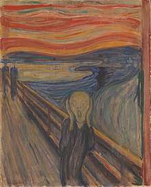
The 1883 Krakatoa eruption darkened the sky worldwide for years afterwards and produced spectacular sunsets throughout the world for many months. British artist William Ashcroft made thousands of colour sketches of the red sunsets halfway around the world from Krakatoa in the years after the eruption. The ash caused "such vivid red sunsets that fire engines were called out in New York, Poughkeepsie, and New Haven to quench the apparent conflagration."[19] This eruption also produced a Bishop's Ring around the sun by day, and a volcanic purple light at twilight. In 2004, an astronomer proposed the idea that the red sky shown in Edvard Munch's 1893 painting The Scream is also an accurate depiction of the sky over Norway after the eruption.[20]
Weather watchers of the time tracked and mapped the effects on the sky. They labelled the phenomenon the "equatorial smoke stream".[21] This was the first identification of what is known today as the jet stream.[22] For several years following the eruption, it was reported that the moon appeared to be blue and sometimes green. This was because some of the ash clouds were filled with particles about 1 µm wide – the right size to strongly scatter red light, while allowing other colours to pass. White moonbeams shining through the clouds emerged blue, and sometimes green. People also saw lavender suns and, for the first time, recorded noctilucent clouds.[19]
Possible causes
The fate of northern Krakatoa has been the subject of some dispute among geologists. It was originally proposed that the island had been blown apart by the force of the eruption. Most of the material deposited by the volcano is clearly magmatic in origin, and the caldera formed by the eruption is not extensively filled with deposits from the 1883 eruption. This indicates that the island subsided into an empty magma chamber at the end of the eruption sequence, rather than having been destroyed during the eruptions.
The established hypotheses – based on the findings of contemporary investigators – assume that part of the island subsided before the first explosions on the morning of 27 August. This forced the volcano's vents to be below sea level, causing:
- major flooding which created a series of phreatic explosions (interaction of ground water and magma).
- seawater to cool the magma enough for it to crust over and produce a "pressure cooker" effect that was relieved only when explosive pressures were reached.
There is geological evidence which does not support the assumption that only subsidence before the explosion was the cause. For instance, the pumice and ignimbrite deposits are not of a kind consistent with a magma-seawater interaction. These findings have led to other hypotheses:
- an underwater land slump or partial subsidence suddenly exposed the highly pressurized magma chamber, opening a pathway for seawater to enter the magma chamber and setting the stage for a magma-seawater interaction.
- the final explosions may have been caused by magma mixing: a sudden infusion of hot basaltic magma into the cooler and lighter magma in the chamber below the volcano. This would have resulted in a rapid and unsustainable increase in pressure, leading to a cataclysmic explosion. Evidence for this theory is the existence of pumice consisting of light and dark material, the dark material being of much hotter origin. Such material reportedly is less than five per cent of the content of the Krakatoa ignimbrite and some investigators have rejected this as a prime cause of the 27 August explosions.
A numerical model for a Krakatoa hydrovolcanic explosion and the resulting tsunami was described by Mader & Gittings, in 2006.[23] A high wall of water is formed that is initially higher than 100 metres driven by the shocked water, basalt and air.
Verbeek investigation
Although the violent phase of the 1883 eruption was over by late afternoon of 27 August, after light returned by 29 August, reports continued for months that Krakatoa was still in eruption. One of the earliest duties of Verbeek's committee was to determine if this was true and also verify reports of other volcanoes erupting on Java and Sumatra. In general, these were found to be false, and Verbeek discounted any claims of Krakatoa still erupting after mid-October as due to steaming of hot material, landslides due to heavy monsoon rains that season, and "hallucinations due to electrical activity" seen from a distance.
No signs of further activity were seen until 1913, when an eruption was reported. Investigation could find no evidence the volcano was awakening, and it was determined that what had been mistaken for renewed activity had actually been a major landslide (possibly the one which formed the second arc to Rakata's cliff).
Examinations after 1930 of bathymetric charts made in 1919 show evidence of a bulge indicative of magma near the surface at the site that became Anak Krakatau.
Comparison of selected volcanic eruptions
| Eruptions | Country | Location | Year | Column height (km) | Volcanic Explosivity Index | N. Hemisphere summer anomaly (°C) | Fatalities |
|---|---|---|---|---|---|---|---|
| Mount Vesuvius | Italy | Mediterranean Sea | 79 | 30 | 5 | ? | >2,000 |
| Hatepe (Taupo) | New Zealand | Ring of Fire | 183 | 37 | 7 | ? | ? |
| Baekdu | China / North Korea | Ring of Fire | 969 | 36 | 6–7 | ? | ? |
| 1257 eruption of Mount Samalas | Indonesia | Ring of Fire | 1257 | 40 | 7 | −2.0 | ? |
| Huaynaputina | Peru | Ring of Fire | 1600 | 46 | 6 | −0.8 | ≈1,400 |
| Tambora | Indonesia / Dutch East-Indies | Ring of Fire | 1815 | 43 | 7 | −0.5 | >71,000 |
| 1883 eruption of Krakatoa | Indonesia / Dutch East-Indies | Ring of Fire | 1883 | 36 | 6 | −0.3 | 36,600 |
| Santa María | Guatemala | Ring of Fire | 1902 | 34 | 6 | no anomaly | 6,000 |
| Novarupta | USA, Alaska | Ring of Fire | 1912 | 32 | 6 | −0.4 | 2 |
| Mount St Helens | USA, Washington | Ring of Fire | 1980 | 19 | 5 | no anomaly | 57 |
| El Chichón | Mexico | Ring of Fire | 1982 | 32 | 4–5 | >2,000 | |
| Nevado del Ruiz | Colombia | Ring of Fire | 1985 | 27 | 3 | no anomaly | 23,000 |
| Mount Pinatubo | Philippines | Ring of Fire | 1991 | 49 | 6 | −0.5 | 1,202 |
Vesuvius is estimated to have killed thousands, yet the death toll is uncertain: so far, evidence of fewer than 2,000 human deaths has been identified.[24]
In popular culture
- The explosion has been theorized to be a source of inspiration for Edvard Munch's The Scream. The reddish sky in the background is the artist's memory of the effects of the powerful volcanic eruption of Krakatoa, which deeply tinted sunset skies red in parts of the Western hemisphere for months during 1883 and 1884, about a decade before Munch painted The Scream.[25]
- The Newbery Medal-winning 1947 young adult (YA) novel The Twenty-One Balloons, by William Pène du Bois, features the 1883 eruption of Krakatoa as a major plot point.
- The 1969 disaster film Krakatoa, East of Java is very loosely based on the 1883 eruption. The title is a notorious geographic error, as Krakatoa is west of Java; the producers wanted "East" instead, to suggest the "Far East."
- The 1883 eruption of Krakatoa contributes to the global cooling and subsequent dystopia seen in the 2018 video game Frostpunk.[26]
See also
- Fair Wind to Java
- Krakatit
- Krakatoa documentary and historical materials
- List of natural disasters by death toll
- List of volcanoes in Indonesia
- The Devil at 4 O'Clock
- Vog
Notes
- A spike of more than 2½ inches of mercury (ca 85 hPa) is equal to approximately 180 dBSPL; to compare this impact, the human threshold for pain is 134 decibels (dBSPL); and short-term hearing effect damage can occur at 120 dBSPL;[7]:219
- A documentary film showed tests made by a research team at the University of Kiel, Germany, of pyroclastic flows moving over water. See Freundt, Armin (2002). "Entrance of hot pyroclastic flows into the sea: experimental observations". Bulletin of Volcanology. 65 (2–3): 144–164. Bibcode:2002BVol...65..144F. doi:10.1007/s00445-002-0250-1. Retrieved 10 April 2012. The tests revealed that hot ash travelled over the water on a cloud of superheated steam, continuing to be a pyroclastic flow after crossing water; the heavy matter precipitated out of the flow shortly after initial contact with the water, creating a tsunami due to the precipitate mass.
References
- Thornton, Ian W. B. (1997). Krakatau: The Destruction and Reassembly of an Island Ecosystem. Harvard University Press. pp. 9–11. ISBN 978-0-674-50572-8.
- Monique R. Morgan (January 2013). "The Eruption of Krakatoa (also known as Krakatau) in 1883". BRANCH: Britain, Representation and Nineteenth-Century History. Retrieved 5 February 2019.
- "How Krakatoa made the biggest bang"; The Independent, 3 May 2006
- Symons, G.J. (ed) The Eruption of Krakatoa and Subsequent Phenomena (Report of the Krakatoa Committee of the Royal Society). London, 1888. Internet Archive. 1888.
- Oliveira, Justin M.; Vedo, Sabrina; Campbell, Michael D.; Atkinson, Joseph P. (2010). "KSC VAB Aeroacoustic Hazard Assessment" (PDF). KSC Engineering, NASA. p. 43. Retrieved 15 November 2016.
- "The eruption of Krakatoa, August 27, 1883". Commonwealth of Australia 2012, Bureau of Meteorology. Archived from the original on 18 March 2016. Retrieved 5 April 2012.
- Winchester, Simon (2003). Krakatoa: The Day the World Exploded, August 27, 1883. Penguin/Viking. ISBN 978-0-670-91430-2.
- "How Volcanoes Work – Krakatau, Indonesia 1883". Department of Geological Sciences, San Diego State University. Retrieved 28 January 2017.
- Mandeville, C.W.; Carey, S; Sigurdsson, H. & King, J. (1994). "Paleomagnetic evidence for high-temperature emplacement of the 1883 subaqueous pyroclastic flows from Krakatau Volcano, Indonesia". Journal of Geophysical Research: Solid Earth. 99 (B5): 9487–9504. Bibcode:1994JGR....99.9487M. doi:10.1029/94JB00239.
- Press, Frank (November 1956). "Volcanoes, ice, and destructive waves" (PDF). Engineering and Science. 20 (2): 26–30. ISSN 0013-7812. Retrieved 5 April 2007.
Fortunately, the tide gauges of 1883 were sufficiently well designed to provide fairly good records of the Krakatoa waves. Thus we have instrumental data for the Krakatoa sea waves from such widely separated places as Honolulu, San Francisco, Colon, South Georgia and English Channel ports.
- Pararas-Carayannis, George (2003). "Near and far-field effects of tsunamis generated by the paroxysmal eruptions, explosions, caldera collapses and massive slope failures of the Krakatau volcano in Indonesia on August 26–27, 1883" (PDF). Science of Tsunami Hazards. 21 (4). The Tsunami Society. pp. 191–201. ISSN 8755-6839. Retrieved 29 December 2007.
- Mader, Charles. (2006). Numerical Modeling for the Krakatoa Hydrovolcanic Explosion and Tsunami. Science of Tsunami Hazards. 24. 174.
- Bradley, Raymond S. (June 1988). "The explosive volcanic eruption signal in northern hemisphere continental temperature records" (PDF). Climatic Change. 12 (3): 221–243. Bibcode:1988ClCh...12..221B. doi:10.1007/bf00139431. ISSN 0165-0009 – via Springer.
- "Los Angeles and San Diego rainfall" (PDF).
- Kuhn, Gerald G. and Shepard, Francis Parker; Sea Cliffs, Beaches, and Coastal Valleys of San Diego County: Some Amazing Histories and Some Horrifying Implications; p. 32. ISBN 9780520051188
- Kane, R.P.; Kane (1 August 1997). "Relationship of El Niño–Southern Oscillation and Pacific Sea Surface Temperature with Rainfall in Various Regions of the Globe". Monthly Weather Review. 125 (8): 1792–1800. Bibcode:1997MWRv..125.1792K. doi:10.1175/1520-0493(1997)125<1792:roenos>2.0.co;2.
- Mass, Clifford F.; Portman, David A.; Mass, Clifford F.; Portman, David A. (1 June 1989). "Major Volcanic Eruptions and Climate: A Critical Evaluation" (PDF). Journal of Climate. 2 (6): 566–593. Bibcode:1989JCli....2..566M. doi:10.1175/1520-0442(1989)002<0566:mveaca>2.0.co;2. JSTOR 26194042.
- "USGS: Volcano Hazards Program". volcanoes.usgs.gov.
- "Blue Moon". NASA Science. Retrieved 26 August 2013.
-
- "Krakatoa provided backdrop to Munch's scream". The Age. Melbourne. 11 December 2003. Retrieved 15 November 2010.
- "Why the sky was red in Munch's 'The Scream'". CNN. Reuters. 10 December 2003. Retrieved 15 November 2010.
- Panek, Richard (8 February 2004). "'The Scream,' East of Krakatoa". The New York Times. Retrieved 15 November 2010.
- Bishop, S.E. (29 January 1885). "Krakatoa". Nature. 31 (796): 288–289. Bibcode:1885Natur..31..288B. doi:10.1038/031288b0.
- Winchester, Simon (15 April 2010). "A Tale of Two Volcanos". The New York Times. Retrieved 15 November 2010.
- Mader, Charles L.; Gittings, Michael L. (2006). "Numerical model for the Krakatoa hydrovolcanic explosion and tsunami". Science of Tsunami Hazards. 24 (3): 174–182.
- "A New Forensic Approach to Past Mass Disasters: The Human Victims of Vesuvius".
- Olson, Donald W.; Russell L. Doescher; Marilynn S. Olson (May 2005). "The Blood-Red Sky of the Scream". APS News. American Physical Society. 13 (5). Retrieved 22 December 2007.
- "Frostpunk Celebrates its First Year with over 1.4 Million Copies Sold". 29 April 2019.
Bibliography
- Cruijff, Henk J. & Koehler, R. B. (2006). "Question 15/05: Dutch Gunboat Berouw". Warship International. XLIII (2): 146–147. ISSN 0043-0374.
- Dickins, Rosie; The Children's Book of Art (An introduction to famous paintings), Usborne Publishing Ltd., Usborne House, 83–85 Saffron Hill, London ISBN 978-0-439-88981-0 (2005)
- Furneaux, Rupert; Krakatoa (1965) London, Secker and Warburg.
- Self, Stephen; Rampino, Michael R. (1981). "The 1883 eruption of Krakatau". Nature. 294 (5843): 699–704. Bibcode:1981Natur.294..699S. doi:10.1038/294699a0.
- Simkin, Tom and Richard S, Fiske (editors); Krakatau, 1883 – the volcanic eruption and its effects (1983) Washington, D.C. : Smithsonian Institution Press. ISBN 0-87474-841-0
- Verbeek, Rogier Diederik Marius (1884). "The Krakatoa eruption". Nature. 30 (757): 10–15. Bibcode:1884Natur..30...10V. doi:10.1038/030010a0.
- Verbeek, Rogier Diederik Marius; Krakatau. Batavia, 1885, Internet Archive link
- Winchester, Simon, Krakatoa: The Day the World Exploded: August 27, 1883, New York: Harper Collins (2003), ISBN 978-0-06-083859-1