Royal Borough of Kensington and Chelsea
The Royal Borough of Kensington and Chelsea (RBKC) is an Inner London borough with royal status. It is the smallest borough in London and the second smallest district in England; it is one of the most densely populated administrative regions in the United Kingdom. It includes affluent areas such as Notting Hill, Kensington, South Kensington, Chelsea, and Knightsbridge.
Kensington and Chelsea | |
|---|---|
Royal borough | |
 Coat of arms Council logo | |
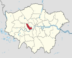 Kensington and Chelsea shown within Greater London | |
| Sovereign state | United Kingdom |
| Constituent country | England |
| Region | London |
| Ceremonial county | Greater London |
| Created | 1 April 1965 |
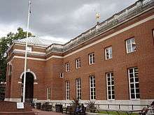
| Admin HQ | Holland Street |
| Government | |
| • Type | London borough council |
| • Body | Kensington and Chelsea London Borough Council |
| • Leadership | Leader and Cabinet (Conservative) |
| • Mayor | Cllr Will Pascall |
| • London Assembly | Tony Devenish (Conservative) AM for West Central |
| • MPs | Felicity Buchan (Conservative) Greg Hands (Conservative) |
| • EU Parliament | London |
| Area | |
| • Total | 4.68 sq mi (12.13 km2) |
| Area rank | 316th (of 317) |
| Population (mid-2018 est.) | |
| • Total | 156,197 |
| • Rank | 127th (of 317) |
| • Density | 33,000/sq mi (13,000/km2) |
| • Ethnicity[1] | 39.3% White British 2.3% White Irish 0.1% White Gypsy or Irish Traveller 28.9% Other White 1.1% White & Black Caribbean 0.7% White & Black African 1.9% White & Asian 2% Other Mixed 1.6% Indian 0.6% Pakistani 0.5% Bangladeshi 2.5% Chinese 4.8% Other Asian 3.5% Black African 2.1% Black Caribbean 1% Other Black 4.1% Arab 3.1% Other |
| Time zone | UTC (GMT) |
| • Summer (DST) | UTC+1 (BST) |
| Postcodes | NW, SW, W |
| Area code(s) | 020 |
| ONS code | 00AW |
| GSS code | E09000020 |
| Police | Metropolitan Police |
| Website | http://www.rbkc.gov.uk/ |
The borough is immediately west of the City of Westminster and east of the London Borough of Hammersmith and Fulham. It contains major museums and universities in Albertopolis, department stores such as Harrods, Peter Jones and Harvey Nichols, and embassies in Belgravia, Knightsbridge and Kensington Gardens. The borough is home to the Notting Hill Carnival, Europe's largest, and contains many of the most expensive residential properties in the world.
The local authority is Kensington and Chelsea London Borough Council. Its motto, adapted from the opening words of Psalm 133, is Quam bonum in Unum habitare, which translates roughly as 'How good it is to dwell in unity'.[2]
History
The borough was formed by the merger of the Royal Borough of Kensington and the Metropolitan Borough of Chelsea, under the London Government Act 1963, which reorganised 86 boroughs and urban districts into 32 London boroughs on 1 April 1965 together with the creation of the Greater London Council.
The new borough was originally intended to be called only "Kensington", but after protests from thousands of Chelsea residents, the then Minister of Housing and Local Government, Sir Keith Joseph, announced on 2 January 1964 that the name of the new borough would be the Royal Borough of Kensington and Chelsea.[3]
Of its history the council states:
"Despite the boroughs being separate originally, Kensington and Chelsea still retain their unique characters. Even the amalgamation of the two boroughs, unpopular as it was at the time, has been accepted. Today conservation combined with the adoption of sympathetic new architecture is seen as a key objective. In every corner of the borough signs of its history can be seen: from Grade 1 listed buildings Kensington Palace and the Royal Hospital, Chelsea to others recalled in street names such as Pottery Lane and Hippodrome Mews."[4]
In 200 years the area has been transformed from a "rural idyll" to a thriving part of the modern metropolis. Chelsea had originally been countryside upon which Thomas More built Beaufort House. He came to Chelsea in 1520 and built the house, which in his day had two courtyards laid out between the house and the river, and in the north of the site acres of gardens and orchards were planted. It was from here in 1535 that More was taken to the Tower and beheaded later that year.[5] This area of Cheyne Walk continued its historic significance; nearby Crosby Hall sits on the river near the Church of Thomas More, and what was once Thomas Carlyle's residence remains on Cheyne Row.
Kensington's royal borough status was granted in 1901 as it was the home of Kensington Palace, where Queen Victoria was born in 1819 and lived until her accession in 1837. Commissioned by King William III, Christopher Wren enlarged and rebuilt the original house in 1689, turning it into a fitting royal residence. With the King came many court officials, servants and followers. Kensington Square, until then a failing venture, became a popular residential area. The Palace was regularly used by reigning monarchs until 1760 and since then by members of the Royal family.[6] Kensington's royal borough status was inherited by the new borough.
During the Second World War, civilians suffered great hardship; there were some 800 deaths and 40,000 injuries. A huge army of civilian volunteers was raised, including Auxiliary Fire Service, Red Cross, Air Raid Wardens and Rescue Services. During the Blitz much damage was caused by explosive and incendiary bombs, especially along Chelsea's riverside. But worse was to come in 1944 with the arrival of the V2 rockets, or flying bombs. Among the buildings either destroyed or seriously damaged, usually with terrible loss of life, were Chelsea Old Church, Church of Our Most Holy Redeemer, Our Lady of Victories, St Mary Abbots, St Stephens Hospital, St Mary Abbot's Hospital, Sloane Square tube station, World's End, the Royal Hospital and Holland House.[7]
Kensington and Chelsea is perhaps best known today for two events that demonstrate both their traditional and modern aspects. The Chelsea Flower Show, held in the grounds of the Royal Hospital every May, is attended by Royalty and the "cream of society"; and the Notting Hill Carnival, held every August Bank Holiday on the streets of North Kensington, has grown over the past 30 years from a small community-based event into Europe's biggest and most exuberant street party, attracting a million plus visitors.
Districts
The borough may be split into the following districts; these differ from the council's electoral wards:
- Albertopolis
- Bayswater (also partly in the City of Westminster)
- Belgravia (also partly in the City of Westminster)
- Brompton
- Chelsea
- Chelsea Harbour (also partly in the London Borough of Hammersmith and Fulham)
- Earl's Court
- Holland Park
- Kensal Green (also partly in Brent)
- Kensington
- Knightsbridge (also partly in the City of Westminster)
- Ladbroke Grove
- North Kensington
- Notting Hill
- South Kensington
- West Brompton
- West Kensington (also partly in the London Borough of Hammersmith and Fulham)
- World's End
See also Kensington and Chelsea parks and open spaces
Demographics
| Population census | ||
|---|---|---|
| Year | Pop. | ±% |
| 1801 | 22,088 | — |
| 1811 | 31,085 | +40.7% |
| 1821 | 43,296 | +39.3% |
| 1831 | 55,865 | +29.0% |
| 1841 | 46,807 | −16.2% |
| 1851 | 69,379 | +48.2% |
| 1861 | 128,828 | +85.7% |
| 1871 | 188,277 | +46.1% |
| 1881 | 247,725 | +31.6% |
| 1891 | 258,015 | +4.2% |
| 1901 | 250,267 | −3.0% |
| 1911 | 242,884 | −3.0% |
| 1921 | 243,589 | +0.3% |
| 1931 | 244,297 | +0.3% |
| 1941 | 233,377 | −4.5% |
| 1951 | 223,144 | −4.4% |
| 1961 | 205,598 | −7.9% |
| 1971 | 189,571 | −7.8% |
| 1981 | 125,892 | −33.6% |
| 1991 | 145,171 | +15.3% |
| 2001 | 158,922 | +9.5% |
| 2011 | 158,649 | −0.2% |
| Note:[8] | ||
At the 2011 census, the borough had a population of 158,649 who were 71% White, 10% Asian, 5% of multiple ethnic groups, 4% Black African and 3% Black Caribbean. Due to its high French population it has long held the unofficial title of the 21st arrondissement of Paris.[9]
In 2005, the borough had more of its land covered by domestic buildings than anywhere else in England at 19%, over half the national average.[10] It also had the fifth highest proportion of land covered by non-domestic buildings at 12%.[10]
As of 2010, statistics released by the Office for National Statistics showed that life expectancy at birth for females was 89.8 years in 2008–2010, the highest in the United Kingdom. Male life expectancy at birth for the same period was 85.1 years.[11] The figures in 1991–1993 were significantly lower: 73.0 years for males (ranking 301st in the nation) and 80.0 for females (ranking 129th). Further investigation indicates a 12-year gap in life expectancy between the affluent wards of Chelsea (Royal Hospital, Hans Town) and the most northerly wards of North Kensington (Golborne, Dalgarno), which have high levels of social housing and poverty.
The borough has a higher proportion (16.6%) of high earners (over £60,000 per year) than any other local government district in the country.[12] It has the highest proportion of workers in the financial sector and the lowest proportion working in the retail sector.
In December 2006, Sport England published a survey which showed that the borough's residents were the fourth most active in England in sports and other fitness activities. 27.9% of the population participate at least three times a week for 30 minutes.[13]
A 2017 study by Trust for London and the New Policy Institute found that Kensington & Chelsea has the greatest income inequality of any London Borough. Private rent for low earners was also found to be the least affordable in London. However, the borough's poverty rate of 28% is roughly in line with the London-wide average.[14]
The following table shows the ethnic group of respondents in the 2001 and 2011 census in Kensington and Chelsea.
Ethnicity
| Ethnic Group | 2001[15] | 2011[16] | ||
|---|---|---|---|---|
| Number | % | Number | % | |
| White: British | 79,594 | 50.08% | 62,271 | 39.25% |
| White: Irish | 5,183 | 3.26% | 3,715 | 2.34% |
| White: Gypsy or Irish Traveller | 119 | 0.08% | ||
| White: Other | 40,147 | 25.26% | 45,912 | 28.94% |
| White: Total | 124,924 | 78.61% | 112,017 | 70.61% |
| Asian or Asian British: Indian | 3,226 | 2.03% | 2,577 | 1.62% |
| Asian or Asian British: Pakistani | 1,203 | 0.76% | 911 | 0.57% |
| Asian or Asian British: Bangladeshi | 1,148 | 0.72% | 836 | 0.53% |
| Asian or Asian British: Chinese | 2,592 | 1.63% | 3,968 | 2.50% |
| Asian or Asian British: Other Asian | 2,160 | 1.36% | 7,569 | 4.77% |
| Asian or Asian British: Total | 10,329 | 6.50% | 15,861 | 10.00% |
| Black or Black British: African | 6,013 | 3.78% | 5,536 | 3.49% |
| Black or Black British: Caribbean | 4,101 | 2.58% | 3,257 | 2.05% |
| Black or Black British: Other Black | 967 | 0.61% | 1,540 | 0.97% |
| Black or Black British: Total | 11,081 | 6.97% | 10,333 | 6.51% |
| Mixed: White and Black Caribbean | 1,290 | 0.81% | 1,695 | 1.07% |
| Mixed: White and Black African | 1,057 | 0.67% | 1,148 | 0.72% |
| Mixed: White and Asian | 1,863 | 1.17% | 3,021 | 1.90% |
| Mixed: Other Mixed | 2,295 | 1.44% | 3,122 | 1.97% |
| Mixed: Total | 6,505 | 4.09% | 8,986 | 5.66% |
| Other: Arab | 6,455 | 4.07% | ||
| Other: Any other ethnic group | 4,997 | 3.15% | ||
| Other: Total | 6,080 | 3.83% | 11,452 | 7.22% |
| Black, Asian, and minority ethnic: Total | 33,995 | 21.39% | 46,632 | 29.39% |
| Total | 158,919 | 100.00% | 158,649 | 100.00% |
Politics

As of 2018, the Council has 36 Conservative, 13 Labour and 1 Liberal Democrat councillors.[17] The first past the post electoral system is used. The Labour or Liberal councillors have tended to represent areas of the borough with pockets of economic deprivation; some marginal wards in the borough are concentrated towards the north, where north Kensington meets Kilburn, Kensal Rise/Green and Ladbroke Grove. All the wards in Holland Park, Notting Hill, Kensington, South Kensington, and Chelsea have been safe Conservative seats since the Council's creation in 1965.
The borough has combined a number of services and departments with its neighbours, Hammersmith & Fulham and Westminster City Council.
The borough is divided between two constituencies represented in the House of Commons of the Parliament of the United Kingdom:
- Kensington, held by Felicity Buchan for the Conservative Party, and
- Chelsea and Fulham (partly in Hammersmith & Fulham), held by Greg Hands for the Conservative Party.
At the 2005 General Election, the borough was divided differently:
- Kensington and Chelsea, held by Sir Malcolm Rifkind for the Conservative Party, and
- Regent's Park and Kensington North (partly in City of Westminster), held by Karen Buck for the Labour Party.
Rifkind held the Kensington seat until the 2015 General Election when he stood down after becoming embroiled in a scandal, uncovered by a television investigation, over accepting money in return for access to influential British diplomats and politicians.[18]
| From 1885 | From Feb 1974 | From 1997 | From 2010 |
|---|---|---|---|
| Kensington North | Kensington | Part of Regent's Park and Kensington North | Kensington |
| Kensington South | Kensington and Chelsea | ||
| Chelsea | Part of Chelsea and Fulham | ||
Two of the more notable council leaders were Nicholas Freeman, from 1977 until 1989, and Sir Merrick Cockell who held the position from 2000 to 2013.
Public transport
Underground
The borough has 12 tube stations, on five of the 12 London Underground lines:
with stations at South Kensington, Gloucester Road, Kensington High Street, Earl's Court, Sloane Square, West Brompton, Notting Hill Gate, Holland Park, Latimer Road, Knightsbridge, Westbourne Park and Ladbroke Grove.
Crossrail
Chelsea (SW3, SW10 and partly SW1) has significantly less Underground access than Kensington, the only station within Chelsea being Sloane Square. There have for some time been long-term plans for a Chelsea-Hackney line, with a station in the King's Road near Chelsea Old Town Hall, and possibly another at Sloane Square. As of June 2019, the plans for Crossrail 2 materialising show the proposed route tunnelling through Chelsea and featuring a station on the site of Dovehouse Green. The future of this station, being the only fully new station on the proposed line, remains ambiguous; initial scrapping of the station idea [19] have been decried by withstanding placement of the station on official Transport for London information on the route.[20]
A Crossrail station on the original Crossrail route, from Paddington to Reading, has been proposed and endorsed by the council.[21] This station would be located near the northern end of Ladbroke Grove, and would serve the areas of North Kensington and Kensal. The council supports this station concept as it would renew infrastructure and build regeneration benefits in the area.
National Rail and Overground
Paddington and Victoria are the nearest major railway termini; National Rail stations in the borough are Kensington (Olympia) and West Brompton (and partly Kensal Green), both served by London Overground and Southern.
Buses
Many London bus routes pass through the borough, most of them along King's Road, Fulham Road, Kensington High Street and Ladbroke Grove.
Travel to work
In March 2011, the main forms of transport that residents used to travel to work were: underground, metro, light rail, tram, 23.6% of all residents aged 16–74; driving a car or van, 8.2%; on foot, 8.2%; bus, minibus or coach, 8.0%; work mainly at or from home, 7.0%; bicycle, 3.1%; train, 2.1%.[22]
Social housing and Grenfell tower fire

The RBKC is a major provider of social housing in the borough owning 9,459 properties.[23] Of these over 73% are tenanted, with the remainder being leasehold.[23] The management of this housing was devolved to the Kensington and Chelsea TMO (KCTMO), a tenant management organisation. Properties included Trellick Tower.
The 2017 Grenfell Tower fire, in which a public-housing tower block was completely destroyed, with the loss of 72 lives, drew international attention to the borough. After widespread criticism of the borough council's response to the fire,[24][25] responsibility for providing services to those affected by the fire was taken away from RBKC.[26] Prime Minister Theresa May previously branded the response to the tragedy "not good enough", with Whitehall civil servants drafted in as part of a beefed-up operation in the local area. Prof Anna Stec who gave evidence as an expert witness to the Grenfell Tower Inquiry has urged the authorities to test rescue workers, nearby residents and survivors for carcinogenic chemicals following the fire.[27]
Religion
The borough has a number of notable churches, including:
- Brompton Oratory – Roman Catholic
- Chelsea Old Church (All Saints) – Church of England
- Holy Trinity Brompton – Church of England
- St Columba's Church, Pont Street – Church of Scotland
- St Luke's Church, Chelsea, Sydney Street – Church of England
- St Mary Abbots – Church of England
- St Sophia's Cathedral – Greek Orthodox Church
- Kensington Temple – Elim Pentecostal Church
- Fetter Lane Moravian Church - "Moravian Church"
It is home to a small Spanish and Portuguese synagogue, several mosques and the Sikh Central Gurudwara in Holland Park. There are two Armenian churches - Saint Sarkis Armenian Church and Church of Saint Yeghiche. Westminster Synagogue is also partially located in the borough.
According to the 2001 Census, 24% of the borough's population identified themselves as being non-religious or chose not to state their faith.
Featured places
Within the borough there are several of London's tourist attractions and landmarks:
- Brompton Oratory
- Earl's Court
- Harrods
- Hill House School
- Imperial College
- Jumeirah Carlton Tower
- Kensington Arcade
- Kensington High Street
- Kensington Palace
- King's Road
- Ladbroke Grove
- Leighton House Museum
- Notting Hill Gate
- Olympia (part)
- Portobello Road
- Royal Albert Hall
- Royal Hospital Chelsea
- Saatchi Gallery
- Sloane Street
- The Science Museum and Natural History Museum
- Victoria & Albert Museum
- Stamford Bridge
Education
Schools
The council's education department finances state schools.[28]
London's Poverty Profile - a 2017 study by Trust for London and the New Policy Institute - found that 75% of 19-year-olds in Kensington and Chelsea have at least a C in their GCSE English and Maths. This is the highest success rate in London.[14]
Independent preparatory schools
- Hill House School: whose notable alumni include H. R. H. The Prince of Wales and Conservative MP Jacob Rees-Mogg.
- Sussex House School
Further education
- Kensington and Chelsea College
- St Charles Catholic Sixth Form College
Universities
- English National Ballet School- in the heart of Chelsea
- Royal College of Art – the main campus is in South Kensington, with the sculpture department in Battersea.
- Royal College of Music
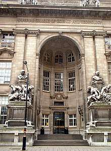
- Imperial College London – the main campus is in South Kensington.
- Heythrop College – a Constituent College of the University of London specialising in Theology & Philosophy
- Richmond, The American International University in London – the secondary campus is in Kensington.
- Fordham University - maintains a campus through a partnership with Heythrop College
Public libraries
Libraries include the Kensington Central Library, Chelsea Library, Kensal Library, Brompton Library, North Kensington Library and the Notting Hill Gate Library.[29]
International relations
See also
- Tri-borough shared services
References
- 2011 Census: Ethnic group, local authorities in England and Wales, Office for National Statistics (2012). See Classification of ethnicity in the United Kingdom for the full descriptions used in the 2011 Census.
- "How council works: our Mayor: Coat of Arms". Royal Borough of Kensington and Chelsea. Retrieved 16 June 2017.
- The Times, 3 January 1964:Chelsea Name Retained: New Decisions on Three Boroughs Linked 2018-06-14
- https://www.rbkc.gov.uk/vmhistory/general/vm_hs_p16.asp
- "Thomas More Comes to Chelsea". Rbkc.gov.uk. Retrieved 18 November 2018.
- "Royalty Comes to Kensington". Rbkc.gov.uk. Retrieved 18 November 2018.
- "The Boroughs at War". Rbkc.gov.uk. Retrieved 18 November 2018.
- "Kensington: Total Population". A Vision of Britain Through Time. Great Britain Historical GIS Project. Retrieved 6 September 2011.
- Global Business. "High earners say au revoir to France". The Daily Telegraph. Retrieved 14 August 2012.
- Key Statistics: Dwellings; Quick Statistics: Population Density; Physical Environment: Land Use Survey 2005
- Nadine Burham-Marshalleck. "Kensington & Chelsea has UK's highest life expectancy - South West Londoner". Swlondoner.co.uk. Retrieved 16 June 2017.
- "Top ten fastest growing affluent areas | Business | guardian.co.uk". Archive.is. Retrieved 18 November 2018.
- "Archived copy". Archived from the original on 25 February 2010. Retrieved 25 February 2010.CS1 maint: archived copy as title (link)
- "London's Poverty Profile". Trust for London. Retrieved 19 July 2018.
- "KS006 - Ethnic group". NOMIS. Retrieved 30 January 2016.
- "Ethnic Group by measures". NOMIS. Retrieved 8 January 2016.
- "Local council elections 2018 - Results". Royal Borough of Kensington and Chelsea. Retrieved 31 October 2018.
- "Malcolm Rifkind to stand down as an MP at the election after lobbying controversy". www.newstatesman.com. Retrieved 3 June 2015.
- https://web.archive.org/web/20180327183856/http://www.cityam.com/267275/crossrail-2-route-shake-up-transport-londons-business-case
- https://crossrail2.co.uk/route/route-map/
- https://www.rbkc.gov.uk/parking-transport-and-streets/getting-around/kensal-portobello-crossrail-station
- "2011 Census: QS701EW Method of travel to work, local authorities in England and Wales". Office for National Statistics. Retrieved 23 November 2013. Percentages are of all residents aged 16-74 including those not in employment. Respondents could only pick one mode, specified as the journey’s longest part by distance.
- "Business Plan 2014-17" (PDF). kctmo.org.uk/. Kensington & Chelsea Tenant Management Organisation. Retrieved 18 June 2017.
- Horton, Helena (19 June 2017). "Anger as leader of Kensington Council appears to blame Grenfell residents for sprinklers not being installed". telegraph.co.uk. Daily Telegraph. Retrieved 19 June 2017.
- MacAskill, Ewen (19 June 2017). "Council sidelined in Grenfell Tower response as leader refuses to quit". Guardian.co.uk. The Guardian. Retrieved 19 June 2017.
- Flood, Rebecca (18 June 2017). "Specialist team set up after Grenfell Tower fire after response 'not good enough'". Express.co.uk. Daily Express. Retrieved 18 June 2017.
- "Grenfell soil tests 'reveal huge numbers of cancer forming toxins'". Daily Telegraph. 13 October 2018. Retrieved 7 December 2018.
- "Family and Children's Services". Royal Borough of Kensington and Chelsea. 14 June 2016. Retrieved 16 June 2017.
- http://www.rbkc.gov.uk/leisureandlibraries.aspx Royal Borough of Kensington and Chelsea. Retrieved 13 January 2009.
- "British towns twinned with French towns [via WaybackMachine.com]". Archant Community Media Ltd. Archived from the original on 5 July 2013. Retrieved 20 July 2013.
External links
| Wikivoyage has a travel guide for South Kensington-Chelsea. |
| Wikimedia Commons has media related to Royal Borough of Kensington and Chelsea. |
| Districts |
|  |
|---|---|---|
| Attractions |
| |
| Theatres |
| |
| Royal Parks |
| |
| Street markets |
| |
| Constituencies |
| |
| Squares and streets |
| |
| Bridges | ||
| Tube and railway stations |
| |
| Pubs |
| |
| Other topics |
| |
| ||