London Borough of Hackney
The London Borough of Hackney (/ˈhækni/ (![]()
Hackney | |
|---|---|
Borough | |
 Coat of arms Council logo | |
 Hackney shown within Greater London | |
| Sovereign state | United Kingdom |
| Constituent country | England |
| Region | London |
| Ceremonial county | Greater London |
| Created | 1 April 1965 |
| Admin HQ | Mare Street, Hackney |
| Government | |
| • Type | London borough council |
| • Body | Hackney London Borough Council |
| • Leadership | Mayor & Cabinet (Labour) |
| • Mayor | Philip Glanville (Labour) |
| • London Assembly | Jennette Arnold (Labour) AM for North East |
| • MPs | Diane Abbott (Labour) Meg Hillier (Labour) |
| • EU Parliament | London |
| Area | |
| • Total | 7.36 sq mi (19.06 km2) |
| Area rank | 312th (of 317) |
| Population (mid-2018 est.) | |
| • Total | 279,665 |
| • Rank | 50th (of 317) |
| • Density | 38,000/sq mi (15,000/km2) |
| • Ethnicity[1] | 36.2% White British 2.1% White Irish 0.2% White Gypsy or Irish Traveller 16.2% Other White 2% White & Black Caribbean 1.2% White & Black African 1.2% White & Asian 2% Other Mixed 3.1% Indian 0.8% Pakistani 2.5% Bangladeshi 1.4% Chinese 2.7% Other Asian 11.4% Black African 7.8% Black Caribbean 3.9% Other Black 0.7% Arab 4.6% Other |
| Time zone | UTC (GMT) |
| • Summer (DST) | UTC+1 (BST) |
| Postcodes | E, EC, N |
| ONS code | 00AM |
| GSS code | E09000012 |
| Police | Metropolitan Police |
| Website | http://www.hackney.gov.uk/ |
The London Plan issued by the Greater London Authority assigns whole boroughs to sub-regions for statutory monitoring, engagement and resource allocation purposes. The most recent (2011) iteration of this plan assigns Hackney to the ‘East’ sub-region,[2] while the 2008 and 2004 versions assigned the borough to ‘North’ and ‘East’ sub-regions respectively. The modern borough was formed 1965 by the merger of the Metropolitan Borough of Hackney with the much smaller Metropolitan Boroughs of Stoke Newington and Shoreditch.
Hackney is bounded by Islington to the west, Haringey to the north, Waltham Forest to the north-east, Newham to the east, Tower Hamlets to the south-east and the City of London to the south-west. Hackney was one of the host boroughs of the London Olympics in 2012, with several of the Queen Elizabeth Olympic Park venues falling within its boundaries.
History
Place name origin
In the 13th century the name appears as Hackenaye or Hacquenye, but no certain derivation is advanced.[3] The Concise Oxford Dictionary of Place Names (fourth edition) discusses the origin of the name. The first surviving records of the place name are as Hakney (1231) and Hakeneye (1242 and 1294). The ‘ey’ suffix almost certainly refers to an island; the dictionary favours the interpretation that Hackney means ‘Haka’s island,’ with Haka being a notable local person and the island (or inaccessible place surrounded by marshes) lying close to the River Lea. This was once a much wilder place than today.
The Dictionary suggests that the ‘Hack’ element may also derive from:
- The Old English ‘Haecc’ meaning a hatch – an entrance to a woodland or common.
- Or alternatively from ‘Haca’ meaning a hook, and in this context, a bend of the river.
Given the island context, the ‘hatch’ option is unlikely to be correct, so the favoured 'Haka's Island' or the 'Island on the bend' seem more likely.
The place name will have originally referred to just the island or possibly both the island and the manor of the same name based around it. Subsequently, the name Hackney was applied to the whole ancient parish of Hackney.
Iron Age to Anglo-Saxon period
In the Iron Age and probably until after the Roman period (as the Romans used tribal territories as administrative sub-divisions), the River Lea was considered to separate the territories of the Catuvellauni[4] to the west of the river from the Trinovantes to the east.
The Romans built the Roman road, Ermine Street, which runs through the modern borough under the names Shoreditch High Street and Kingsland Road amongst others.
In the Anglo-Saxon period, the River Lea separated the core territories of the East Saxons (on the east side) from the Middle Saxons (on the western, Hackney side) they often controlled. This continuity of this natural boundary from pre-Roman period may be a result of the differing Saxon groups taking control of pre-defined territories.
After both areas were brought under the control of Alfred the Great, the river became the boundary between the historic counties of Middlesex (Hackney) and Essex (modern Newham, Waltham Forest and Redbridge).
Later history
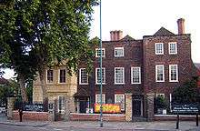
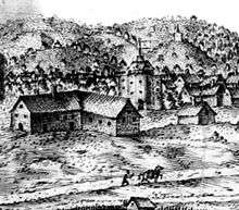
In the Tudor period, the lands of religious orders were seized by the Crown and put up for sale. Thus Hackney became a retreat for the nobility around Hackney Central and Homerton. Henry VIII's Palace was by Lea Bridge roundabout, where BSix Sixth Form College stands today.[5] Sutton House, on Homerton High Street, is the oldest surviving dwelling in Hackney, originally built in 1535 as Bryck Place for Sir Ralph Sadleir, a diplomat. The village of Hackney flourished from the Tudor to late Georgian periods as a rural retreat.
The first documented "hackney coach"—the forerunner of the more generic "hackney carriage"—operated in London in 1621. Current opinion is that the name "hackney," to refer to a London taxi, is derived from the village name.[6] (Hackney, associated with high-stepping horses and horse-drawn carriages, is the root of the French word haquenée, a term used for a small breed of horse,[7] and the Sardinian achetta horse.) Construction of the railway in the 1850s ended Hackney's rural reputation by connecting it to other parts of the city and stimulating development.
London's first Tudor theatres were built at Shoreditch. The Gunpowder Plot was first exposed nearby in Hoxton.[8]
In 1727 Daniel Defoe said of the villages of Hackney
All these, except the Wyck-house, are within a few years so encreas'd in buildings, and so fully inhabited, that there is no comparison to be made between their present and past state: Every separate hamlet is encreas'd, and some of them more than treble as big as formerly; Indeed as this whole town is included in the bills of mortality, tho' no where joining to London, it is in some respects to be call'd a part of it.
This town is so remarkable for the retreat of wealthy citizens, that there is at this time near a hundred coaches kept in it; tho' I will not join with a certain satyrical author, who said of Hackney, that there were more coaches than Christians in it.[9]
The parish church of St John-at-Hackney was built in 1789, replacing the nearby former 16th-century parish church dedicated to St Augustine (pulled down in 1798).
Notable residents from the 17th, 18th and 19th centuries included Robert Aske, William Cecil, Samuel Courtauld, Samuel Hoare, Joseph Priestley and Thomas Sutton.
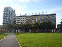
Many grand houses stood in Stoke Newington and Stamford Hill; the latter neighbourhood became a center of Hackney's many Orthodox Jewish residents from the 1930s. Alfred Hitchcock made many of his first films in Hoxton at the Gainsborough Studios in Poole Street.[10]
Following extensive post-war development and immigration since the late 20th century, population pressure has increased and the area's many Georgian and Victorian terraces are being gentrified, warehouses are being converted to housing, and new flats are being built.[11] It was ranked as inner London's 'greenest borough' and London Transport's 'best bike borough 2006',[12] with 62 parks and open spaces, covering 815 acres (3.3 km2).[13] Seven Hackney parks have now achieved Green Flag status.[14] One, Abney Park, became scheduled in 2009 as one of Britain's historic parks and garden at risk from neglect and decay.[15] Hackney Marshes play host to the largest collection of football pitches in Europe. Part of it was used as a site for events of the 2012 Summer Olympics.
Listed buildings and conservation areas
There are 1,300 listed buildings in Hackney, including the Hackney Empire, Tudor Sutton House, and the Grade I medieval St Augustine's Tower. The borough contains 25 conservation areas including Clapton Square and urban open-spaces including Clapton Common and Clissold Park. Conservation areas also protect large areas of Georgian and Victorian housing, and areas of industrial heritage.[16]
Governance
Representation

The Borough is currently divided into twenty-one wards which between them return fifty-seven councillors. Fifteen of the wards return three councillors and the remaining six return two each, in a first past the post system of elections. Ward boundaries are regularly revised, with the last review being in 2014. Until the 2002 revision, the historic boundaries of Hackney and Stoke Newington were retained as a basis for the sub-division of the borough into wards, though the boundary between Hackney and Shoreditch was not re-used to the same degree.[17]
Unlike most other English local authorities, the borough is now governed by a directly-elected mayor who is also the political leader of the council. The mayor – currently Philip Glanville[18] – is supported by a cabinet, councillors and a speaker who fulfils the civic and ceremonial duties previously undertaken by the (non-political) mayor.[19]
The borough comprises two parliamentary constituencies: Hackney North and Stoke Newington (represented by Diane Abbott MP) and Hackney South and Shoreditch (represented by Meg Hillier MP); both are Privy Counsellors and Labour Party Members of Parliament. The borough is in the North East London Assembly constituency returning Jennette Arnold AM, as the directly elected Assembly Member. Hackney is part of the London constituency in the European Parliament.
Administrative Heritage

The constituent parts of the borough are Hackney, Shoreditch and Stoke Newington. Originally Ancient Parishes, these areas have had consistent boundaries since the mediaeval period.
Parishes in Middlesex were grouped into ‘Divisions’, with Stoke Newington part of the Finsbury Division and Hackney and Shoreditch part of the Tower Division. The Tower Division was noteworthy in that the men of the area owed military service to the Tower of London.
The Ancient Parishes provided a framework for both civil (administrative) and ecclesiastical (church) functions, but during the nineteenth century there was a divergence into distinct civil and ecclesiastical parish systems. In London the Ecclesiastical Parishes sub-divided to better serve the needs of a growing population, while the Civil Parishes continued to be based on the same Ancient Parish areas.
The Metropolis Management Act 1855 merged the Civil Parishes of Hackney and Stoke Newington under a new Hackney District. This proved very unpopular, especially in more affluent Stoke Newington and after four unsuccessful attempts the two parishes regained their independence when they were separated by mutual consent under the Metropolis Management (Plumstead and Hackney) Act of 1893.[20]
The London Government Act 1899 converted the three Civil Parishes into Metropolitan Boroughs based on the same boundaries. There were minor rationalisations, notably that Shoreditch absorbed part of the tiny Liberty of Norton Folgate (with the rest going to neighbouring Stepney), while Stoke Newington absorbed the South Hornsey exclaves of Hornsey.
In 1965 the three old boroughs were merged into the new London Borough of Hackney, which adopted a coat of arms that included elements representing its predecessors:
- The shield is surmounted by a representation of Hackney's St. Augustine's Tower.
- An eight-pointed Maltese Cross, for Hackney, which derives from the symbols of the Orders of the Knights Templar and Knights of St. John, both of whom held the Manor of Hackney.
- Bells representing Shoreditch, these are the bells in the nursery rhyme Oranges and Lemons.
- Oaks for Stoke Newington, representing its origins in the Forest of Middlesex.
The council displays, in Hackney Town Hall, a portrait of the Queen wearing the robes of the Most Venerable Order of St John of Jerusalem, of which she is Patron.
Geography
Neighbourhoods
The borough was formed by the merger of the metropolitan boroughs of Hackney, Shoreditch and Stoke Newington, with the boundaries of these very closely based on the Ancient Parishes of the same name; these areas have been consistently defined for many centuries. Historically, the River Lea formed the boundary between the predecessor counties of Middlesex and Essex.
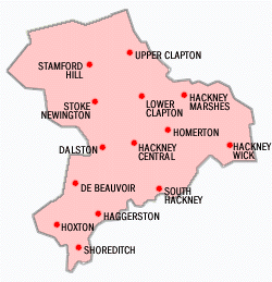
Within these areas are a large number of sub-districts, some of which have sub-districts of their own. These areas are generally based on former hamlets which expanded and merged as the area urbanised. These sub-districts have never been administrative units so have never had any formal boundaries, however a degree of informal definition has developed.
The sub-districts typically take Metropolitan Borough\Ancient Parish boundaries where available, and can also have customary boundaries such as roads, railways, postcode boundaries or a combination of these as publicly understood limits. Despite this, many areas have only a weakly or partially understood extent and it is not unusual for perceptions of place to overlap or change over time.
Although the former boroughs\parishes are the only areas to have had formalised boundaries there is still a degree of nuance with these boundaries too. These areas are described, together with any sub-districts, as follows:
- Hackney
Hackney is seen as part of East London and includes : Homerton, Dalston (including Kingsland and Shacklewell), Upper and Lower Clapton, Hackney Central, Hackney Wick, South Hackney, West Hackney, De Beauvoir Town and Stamford Hill - with the last three of these not always counted as part of East London.
- Shoreditch
Shoreditch is part of the East End\East London and includes the sub-districts of Hoxton and Haggerston.
- Stoke Newington
Stoke Newington proper is part of North London. The formal and traditional eastern boundary is Stoke Newington High Street, but West Hackney is sometimes informally considered part of the area.
Topography & Landscape History
The London Borough of Hackney covers an area of 19.06 square kilometres (7.4 sq mi), rising westward from the Lea to reach 30 metres (98 ft) above sea level at Clapton Common and Stamford Hill. The area around Victoria Park, in the south of the borough lies about 15 metres (49 ft) above sea level..
After the Norman Conquest the area became part of the Forest of Middlesex which covered much of the county, but this gives rise to misunderstanding, as in this context ‘Forest’ is a legal term referring to royal hunting rights and had a weak correlation with woodland cover, especially in the early post-Conquest Period.[21]
By the time of the earliest reliable maps, in the 18th century, the area covered by the modern borough was an agricultural area characterised by enclosed farmland with small hamlets and very little woodland. There were a number of commons most of which survived to become the basis of modern parks. Many of the major roads were present by this time, the road now known as the A10 was Roman, and others, like many in England, may be older.[21]
With the obvious exception of the urbanisation of the area, the greatest changes have been to the waterways and wetlands of the area. The River Lea, the area's primary geographic feature, has lost its grazing marshes and seen the River Lee Navigation created in 1770. This is an artificial channel of the river, passing through Hackney Cut and across the Hackney Marshes to straighten a meander of the natural river. In Roman times and for a long time after, the River Lea was an estuary, tidal as far as Hackney Wick.
At Hackney Wick the Hackney Brook met the Lea; the confluence was very wide when flooded. Hackney Brook was fully culverted in 1860 by the Metropolitan Board of Works.[22]
The New River was opened in 1613, diverting water from the Lea catchment to create a source of drinking water for London. The New River still passes through the borough, close to Finsbury Park and flows towards Islington. Another man-made feature, the Regents Canal also crosses the borough to the south of De Beauvoir Town in the west, joining the Hertford Union Canal below Victoria Park.[22]
Housing and Industry
Much of Hackney retains an inner-city character, but in such places as Dalston large housing estates have been joined by newly developed gated communities. In South Hackney, near Victoria Park, terraced Georgian, Victorian and Edwardian housing still survives.
Light industries in the area around the River Lea employ over 3,000 people.
Geology
The Lea and Hackney Marshes are underlain by alluvium soils; and the higher ground between Homerton and Stamford Hill is formed on a widening bed of London Clay. Brickearth deposits are within tongues of clay extending beneath Clapton Common, Stamford Hill and Stoke Newington High Street. The centre and south western districts lie on river terrace deposits of Taplow Gravel. Victoria Park and Well Street Common lie on flood plain gravel.[22]
Climate
This data was taken between 1971 and 2000 at the nearest national weather station in Greenwich; around 7 miles (11.3 km) south of Hackney Town Hall:
| Climate data for Greenwich Park, elevation: 47 m (154 ft), 1981–2010 normals | |||||||||||||
|---|---|---|---|---|---|---|---|---|---|---|---|---|---|
| Month | Jan | Feb | Mar | Apr | May | Jun | Jul | Aug | Sep | Oct | Nov | Dec | Year |
| Record high °C (°F) | 14.4 (57.9) |
19.7 (67.5) |
21.7 (71.1) |
25.6 (78.1) |
30.0 (86.0) |
32.8 (91.0) |
35.3 (95.5) |
37.5 (99.5) |
30.0 (86.0) |
25.6 (78.1) |
18.9 (66.0) |
15.0 (59.0) |
37.5 (99.5) |
| Average high °C (°F) | 8.1 (46.6) |
8.6 (47.5) |
11.6 (52.9) |
14.6 (58.3) |
18.1 (64.6) |
21.0 (69.8) |
23.4 (74.1) |
23.1 (73.6) |
20.0 (68.0) |
15.5 (59.9) |
11.3 (52.3) |
8.4 (47.1) |
15.3 (59.5) |
| Daily mean °C (°F) | 5.6 (42.1) |
5.7 (42.3) |
8.1 (46.6) |
10.3 (50.5) |
13.5 (56.3) |
16.4 (61.5) |
18.6 (65.5) |
18.5 (65.3) |
15.7 (60.3) |
12.2 (54.0) |
8.6 (47.5) |
5.9 (42.6) |
11.6 (52.9) |
| Average low °C (°F) | 3.1 (37.6) |
2.7 (36.9) |
4.6 (40.3) |
5.9 (42.6) |
8.9 (48.0) |
11.8 (53.2) |
13.7 (56.7) |
13.8 (56.8) |
11.4 (52.5) |
8.8 (47.8) |
5.8 (42.4) |
3.4 (38.1) |
7.8 (46.0) |
| Record low °C (°F) | −9.4 (15.1) |
−9.4 (15.1) |
−7.8 (18.0) |
−2.2 (28.0) |
−1.1 (30.0) |
5.0 (41.0) |
7.2 (45.0) |
6.1 (43.0) |
2.8 (37.0) |
−3.3 (26.1) |
−5.0 (23.0) |
−7.2 (19.0) |
−9.4 (15.1) |
| Average precipitation mm (inches) | 41.6 (1.64) |
36.3 (1.43) |
40.3 (1.59) |
40.1 (1.58) |
44.9 (1.77) |
47.4 (1.87) |
34.6 (1.36) |
54.3 (2.14) |
51.0 (2.01) |
61.1 (2.41) |
57.5 (2.26) |
48.4 (1.91) |
557.4 (21.94) |
| Average precipitation days (≥ 1.0 mm) | 11.4 | 8.5 | 9.8 | 9.0 | 9.2 | 7.4 | 6.3 | 8.1 | 8.6 | 10.9 | 10.9 | 9.5 | 109.4 |
| Mean monthly sunshine hours | 44.7 | 65.4 | 101.7 | 148.3 | 170.9 | 171.4 | 176.7 | 186.1 | 133.9 | 105.4 | 59.6 | 45.8 | 1,410 |
| Source #1: Met Office[23][24][25] | |||||||||||||
| Source #2: BBC Weather[26] | |||||||||||||
Demography
| Population | ||
|---|---|---|
| Year | Pop. | ±% |
| 1801 | 14,609 | — |
| 1811 | 19,523 | +33.6% |
| 1821 | 25,342 | +29.8% |
| 1831 | 35,482 | +40.0% |
| 1841 | 68,246 | +92.3% |
| 1851 | 94,961 | +39.1% |
| 1861 | 172,385 | +81.5% |
| 1871 | 249,810 | +44.9% |
| 1881 | 327,234 | +31.0% |
| 1891 | 369,209 | +12.8% |
| 1901 | 374,132 | +1.3% |
| 1911 | 379,120 | +1.3% |
| 1921 | 368,469 | −2.8% |
| 1931 | 358,117 | −2.8% |
| 1941 | 305,501 | −14.7% |
| 1951 | 260,626 | −14.7% |
| 1961 | 240,521 | −7.7% |
| 1971 | 221,975 | −7.7% |
| 1981 | 179,536 | −19.1% |
| 1991 | 187,792 | +4.6% |
| 2001 | 202,819 | +8.0% |
| 2011 | 246,270 | +21.4% |
| Source: A Vision of Britain through time | ||
In 1801, the civil parishes that form the modern borough had a total population of 14,609. This rose steadily throughout the 19th century, as the district became built up; reaching 95,000 in the middle of that century. When the railways arrived the rate of population growth increased — reaching nearly 374,000 by the turn of the century. This increase in population peaked before World War I, falling slowly in the aftermath until World War II began an exodus from London towards the new towns under the Abercrombie Plan for London (1944).[27] The population is now rising again, and the 2001 census gives Hackney a population of 202,824.[28]
The population is ethnically diverse. Of the resident population, 89,490 (44%) people describe themselves as White British. 24,861 (12%) are in other White ethnic groups, 50,009 (24%) are Black or Black British, 19,791 (9%) are Asian or Asian British, 8,501 (4%) describe themselves as 'Mixed', and 6,432 (3%) as Chinese or Other.

There is also a large Turkish and Kurdish population resident in Hackney. Turkish and Kurdish communities are located in all parts of the borough, though there is a greater concentration in north and central Hackney.
132,931 (66%) of the resident population were British born. A further 10,095 (5%) were born in other parts of Europe, and the remaining 59,798 (29%) born elsewhere in the world.
The 2001 census also shows Christianity is the biggest religion in Hackney, with 44% of residents identifying Christian; 18% identified as Muslim, 4% Jewish, and 3% belonged to other religions. A further 19% stated no religion, and 12% did not state a response. By the 2011 census, residents identifying themselves as Christian fell to 38.6%, whilst those with no religion rose to 28.2%. Judaism had a modest increase, Islam had a small increase, and Hinduism made a slight drop.
32% of households are owner–occupied.
The largest rise of ethnic groups between 2001 and 2011 was 'Other', which increased by 222%. This was followed by 'Mixed', which rose by 84%.
According to the GLA Population Estimate for 2018, 36.4% of the borough's population are White British, 18.1% are "Other White", 10.3% are of Black African heritage, and 6.4% are of Black Caribbean heritage. Hackney is also home to several smaller Asian communities.
Ethnicity
| Ethnic Group | 2001[29] | 2011[30] | ||
|---|---|---|---|---|
| Number | % | Number | % | |
| White: British | 89,490 | 44.1% | 89,030 | 36.2% |
| White: Irish | 6,117 | 3.0% | 5,216 | 2.1% |
| White: Gypsy or Irish Traveller | 474 | 0.2% | ||
| White: Other | 24,861 | 12.3% | 39,897 | 16.2% |
| White: Total | 120,468 | 59.4% | 134,617 | 54.7% |
| Black or Black British: African | 24,290 | 12.0% | 27,976 | 11.4% |
| Black or Black British: Caribbean | 20,879 | 10.3% | 19,168 | 7.8% |
| Black or Black British: Other Black | 4,840 | 2.4% | 9,714 | 3.9% |
| Black or Black British: Total | 50,009 | 24.7% | 56,858 | 23.1% |
| Asian or Asian British: Indian | 7,624 | 3.8% | 7,599 | 3.1% |
| Asian or Asian British: Pakistani | 2,165 | 1.1% | 1,905 | 0.8% |
| Asian or Asian British: Bangladeshi | 5,970 | 2.9% | 6,180 | 2.5% |
| Asian or Asian British: Chinese | 2,377 | 1.2% | 3,436 | 1.4% |
| Asian or Asian British: Other Asian | 1,655 | 0.8% | 6,747 | 2.7% |
| Asian or Asian British: Total | 19,791 | 9.8% | 25,867 | 10.5% |
| Mixed: White and Black Caribbean | 3,075 | 1.5% | 4,989 | 2.0% |
| Mixed: White and Black African | 1,599 | 0.8% | 2,866 | 1.2% |
| Mixed: White and Asian | 1,576 | 0.8% | 3,020 | 1.2% |
| Mixed: Other Mixed | 2,251 | 1.1% | 4,994 | 2.0% |
| Mixed: Total | 8,501 | 4.2% | 15,869 | 6.4% |
| Other: Arab | 1,721 | 0.7% | ||
| Other: Any other ethnic group | 4,055 | 2.0% | 11,338 | 4.6% |
| Other: Total | 4,055 | 2.0% | 13,059 | 5.3% |
| Black, Asian, and minority ethnic: Total | 82,356 | 40.7% | 111,653 | 45.3% |
| Total | 202,824 | 100.00% | 246,270 | 100.00% |
At the 2011 census, 6.3% of the population was Jewish, making it the third biggest in England after London Borough of Barnet and the Hertsmere borough of Hertfordshire.
Every ward remains among the 10% most deprived in the country, with 47% of children living in low-income households.[31]
Hackney has a reputation as one of the most crime-ridden London boroughs, and some of its streets have even been referred to as "Murder Mile",[32] but cooperation between local police and council has resulted in the borough experiencing a bigger drop in crime than in any other London borough in the four-year period up to 2007 (28% reduction).[33]
Hackney has the highest rate of commuters travelling by bicyclein London as of the 2011 census.[34]
Education
In 2002, the borough entered into a ten-year contract with the Learning Trust, an independent collaborative body that organises education for Hackney's 27,000 pupils in over 70 schools, nurseries and play centres. The trust was set up in response to an OFSTED report that identified failings in the then existing system.[35] Two of London's most successful City Academies are in Hackney with another two in development and plans to rebuild or renovate every other Hackney school by 2016. LBH regained responsibility for education in 2012, absorbing the Learning Trust under the new name Hackney Learning Trust.
Public libraries
The London Borough of Hackney has 8 public libraries:[36]
- Clapton Library
- Dalston CLR James Library
- Hackney Central Library
- Homerton Library
- Shoreditch Library
- Stamford Hill Library
- Stoke Newington Library
- Woodberry Down Library
Transport
Hackney has only one London Underground station, on the fringe of the borough. Manor House on the Piccadilly Line is located on its extreme north-western fringe on the boundary with Haringey.
However, three London Overground lines serve Hackney: the North London Line crosses from west to east while the East London Line runs from Highbury & Islington and passes through Dalston Junction and on south through Haggerston, Hoxton, Shoreditch towards destinations south of the River Thames, including Clapham Junction, Crystal Palace, Croydon, and New Cross. Local services on the Lea Valley Lines passed into London Overground on 31 May 2015. Trains originate at London Liverpool Street and head towards either Enfield Town (via Bush Hill Park), Cheshunt (via Turkey Street) or Chingford (via Clapton).
It is proposed that Crossrail 2 will provide Hackney with its first underground station at Dalston with the potential of the future ‘eastern branch’ with stops at Hackney Central and Hackney Wick.

London Overground
North London Line Travelling west to east — nearest London Overground stations are Dalston Kingsland, Hackney Central, Homerton and Hackney Wick
East London Line Travelling north to south — nearest London Overground stations are 'Dalston Junction, Haggerston, Hoxton' and 'Shoreditch High Street'
Lea Valley Lines Travelling south to north - nearest London Overground stations are London Fields, Hackney Downs, Rectory Road, Stoke Newington and Stamford Hill.
Travel to work
In March 2011, the main forms of transport that residents used to travel to work were: bus, minibus or coach, 16.9% of all residents aged 16–74; underground, metro, light rail, tram, 9.2%; bicycle, 9.2%; on foot, 7.5%; driving a car or van, 7.1%; train, 4.6%; work mainly at or from home, 3.5%.[37]
65% of households in Hackney are car free.[38]
Notable people
Attractions and institutions

- Abney Park Cemetery – overgrown Victorian cemetery and Nature Reserve
- Arcola Theatre – studio theatre
- National Centre of Circus Arts – circus school
- Cafe Oto - new music club and daybtime cafe
- Geffrye Museum – decorative arts museum
- Hackney Empire – theatre
- Hackney City Farm
- Hackney One Carnival - carnival street parade
- Hoxton Hall – community centre and performance space
- Newington Green Unitarian Church – London's oldest nonconformist place of worship
- Rio Cinema - A Grade II listed independent Art Deco cinema
- St John's Hoxton – Anglican church (where "Amazing Grace" was written)
- Shoreditch Town Hall
- Sutton House – Heritage house and museum
- The Towers of Hackney
- Victoria Miro Gallery – contemporary art gallery
- Vortex Jazz Club – live jazz venue
- Woodberry Wetlands - Nature Reserve
Twinned towns
The London Borough of Hackney has formal twinning arrangements with:


Hackney has an informal twinning with:

The borough also has informal links with South Africa, Turkey, and Saint Vincent and the Grenadines. The Homerton University Hospital has its own twinning arrangements with the Rambam Health Care Campus (Haifa, Israel) and St George's Hospital (Grenada). Schools are encouraged to pursue links with specific schools abroad – such as the arrangement between Our Lady's and a school in Hangzhou, South West China.[41]
References
- 2011 Census: Ethnic group, local authorities in England and Wales, Office for National Statistics (2012). See Classification of ethnicity in the United Kingdom for the full descriptions used in the 2011 Census.
- "London Places" (PDF). Greater London Authority. Greater London Authority. Archived from the original (PDF) on 6 September 2015. Retrieved 3 September 2015.
-

- "Hackney: Roman Landscape". Building Exploratory:Brickfields.
- 'Hackney: Settlement and Building to c.1800', A History of the County of Middlesex: Volume 10: Hackney (1995), pp. 10–4 Date accessed: 2 October 2006
- "The history of the word "Hackney"". Worldwidewords.org. 11 May 2002. Retrieved 20 November 2011.
- CNRS – Nancy Université. "Centre National de Ressources Textuelles et Lexicales". ATILF. Retrieved 21 June 2015.
- Houses of Parliament factsheet on event Archived 15 February 2005 at the Wayback Machine, accessed 6 March 2007
- "Daniel Defoe, Letter VI: Middx, Herts & Bucks". A Vision of Britain. University of Portsmouth and others. Retrieved 16 June 2015.
- Visiting Hackney Archived 2 January 2008 at the Wayback Machine accessed 10 May 2007
- Location, Location: Best and Worse Hackney One Year On (Channel 4 TV) accessed 7 November 2007
- Hackney wins best bike borough (LBH Press release, 6 April 2006) accessed 7 November 2007
- Parks department (LB Hackney) Archived 9 November 2007 at the Wayback Machine accessed 7 November 2007
- Hackney Today 188 21 July 2008
- English Heritage's 'At Risk' register accessed 5 July 2010
- Hackney Society photographic survey accessed 23 January 2007
- Map of Rectory Ward, which like Westdown, Northwold and Northfield maintained the former Hackney\Stoke N boundaries – from the LBH website https://www.map.hackney.gov.uk/gisMapGallery/Maps/Administrative%20Boundaries/Past%20LBH%20Wards/rectory_1978-2002.pdf Archived 4 October 2015 at the Wayback Machine
- "Hackney elects Philip Glanville as Mayor" Hackney Citizen, accessed 23 December 2016
- The Speaker of Hackney Council Archived 20 November 2008 at the Wayback Machine accessed 27 May 2010
- http://www.british-history.ac.uk/vch/middx/vol8/pp194-200
- The History of the Countryside, Oliver Rackham, 1986
- Hackney: Introduction, A History of the County of Middlesex: Volume 10: Hackney (1995), pp. 1–4. Date accessed: 13 June 2009
- "Greenwich 1981–2010 averages". Met Office. Retrieved 20 November 2018.
- "Hot Spell - August 2003". Met Office. Retrieved 17 December 2018.
- "Record Breaking Heat and Sunshine - July 2006". Met Office. Retrieved 17 December 2018.
- "London Forecast". Met Office. Retrieved 17 December 2018.
- A Vision of Britain through time accessed 20 February 2009
- Statistics for ethnicity , country of birth , and religion "Archived copy". Archived from the original on 10 January 2009. Retrieved 5 February 2010.CS1 maint: archived copy as title (link) are from the UK census.
- "KS006 - Ethnic group". NOMIS. Retrieved 30 January 2016.
- "Ethnic Group by measures". NOMIS. Retrieved 8 January 2016.
- Corporate Assessment Report: London Borough of Hackney (The Audit Commission August 2006) accessed 4 December 2007
- Two more die on 'murder mile' | UK News | The Observer
- Hackney Today 157 23 April 2007 Archived 30 June 2007 at the Wayback Machine accessed 6 June 2007
- https://data.london.gov.uk/dataset/ward-profiles-and-atlas
- Learning Trust history Archived 27 September 2007 at the Wayback Machine accessed 5 May 2007
- "Libraries | Hackney Council". hackney.gov.uk. Retrieved 27 June 2018.
- "2011 Census: QS701EW Method of travel to work, local authorities in England and Wales". Office for National Statistics. Retrieved 23 November 2013. Percentages are of all residents aged 16-74 including those not in employment. Respondents could pick one mode, specified as the journey’s longest part by distance.
- Hackney Cyclists http://www.hackney-cyclists.org.uk/updates13.htm#2013-02-01_census Archived 10 September 2015 at the Wayback Machine
- "British towns twinned with French towns [via WaybackMachine.com]". Archant Community Media Ltd. Archived from the original on 5 July 2013. Retrieved 20 July 2013.
- Barnett, Marissa (27 February 2014). "Austin picks up 13th sister city in London borough of Hackney". Austin American-Statesman. Cox Media Group. Archived from the original on 27 June 2014. Retrieved 28 February 2014.
- Twinning (LB Hackney) Accessed 19 September 2008
External links
![]()
| Wikimedia Commons has media related to London Borough of Hackney. |
- Official site of Hackney council
- Hackney Biodiversity Action Plan
| Districts |
|  |
|---|---|---|
| Attractions and landmarks |
| |
| Parks and open spaces |
| |
| Markets |
| |
| Pubs |
| |
| Places of worship |
| |
| Constituencies |
| |
| Tube and rail stations |
| |
| Other topics |
| |
| ||