London Borough of Haringey
The London Borough of Haringey (pronounced /ˈhærɪŋɡeɪ/ (![]()
London Borough of Haringey | |
|---|---|
London borough | |
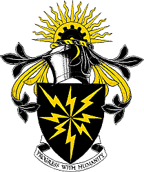 Coat of arms Council logo | |
| Motto(s): Progress With Humanity | |
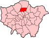
 Haringey shown within Greater London | |
| Sovereign state | United Kingdom |
| Constituent country | England |
| Region | London |
| Ceremonial county | Greater London |
| Created | 1 April 1965 |
| Admin HQ | Wood Green |
| Government | |
| • Type | London borough council |
| • Body | Haringey London Borough Council |
| • Leadership | Leader & Cabinet Cllr Joseph Ejiofor (Labour) |
| • Mayor | Cllr Sheila Peacock |
| • London Assembly | Joanne McCartney (Labour) AM for Enfield and Haringey |
| • MPs | Catherine West (Labour) David Lammy (Labour) |
| • EU Parliament | London |
| Area | |
| • Total | 11.42 sq mi (29.59 km2) |
| Area rank | 302nd (of 317) |
| Population (mid-2018 est.) | |
| • Total | 270,624 |
| • Rank | 56th (of 317) |
| • Density | 24,000/sq mi (9,100/km2) |
| • Ethnicity[1] | 34.7% White British 2.7% White Irish 0.1% White Gypsy or Irish Traveller 23% Other White 1.9% White & Black Caribbean 1% White & Black African 1.5% White & Asian 2.1% Other Mixed 2.3% Indian 0.8% Pakistani 1.7% Bangladeshi 1.5% Chinese 3.2% Other Asian 9% Black African 7.1% Black Caribbean 2.6% Other Black 0.9% Arab 3.9% Other |
| Time zone | UTC (GMT) |
| • Summer (DST) | UTC+1 (BST) |
| Postcodes | N |
| Area code(s) | 020 |
| ONS code | 00AP |
| GSS code | E09000014 |
| Police | Metropolitan Police |
| Website | http://www.haringey.gov.uk/ |
Haringey covers an area of more than 11 square miles (28.5 km2).[3] Some of the more familiar local landmarks include Alexandra Palace, Bruce Castle, Jacksons Lane, Highpoint I and II, and Tottenham Hotspur Football Club. The borough has extreme contrasts:[4] areas in the west, such as Highgate, Muswell Hill and Crouch End are among the most prosperous in the country; in the east of the borough, some wards are classified as being among the most deprived 10% in the country.[5] Haringey is also a borough of contrasts geographically. From the wooded high ground around Highgate and Muswell Hill, at 426.5 feet (130.0 m), the land falls sharply away to the flat, open low-lying land beside the River Lea in the east. The borough includes large areas of green space, which make up more than 25% of its total area.[5]
History
In the Last Glacial Maximum, Haringey was at the edge of a huge glacial mass that reached as far south as Muswell Hill.[6] There is evidence of both Stone Age and Bronze Age activity.[7]
Prior to the Romans' arrival, Haringey was part of a large area covering Essex and Middlesex which was home to a Celtic tribe called Trinobantes.
The Romans' presence is evidenced chiefly by the roads they built through the area. Tottenham High Road was part of the main Roman thoroughfare of Ermine Street. There have also been Roman finds in the borough which suggests possible Roman settlement.
In the 5th and 6th centuries the Saxon invasions brought Haering, the chieftain whose name still lives on today in local placenames.
Haringey remained a rural area until the 18th century when large country houses close to London became increasingly common. The coming of the railways from the mid-nineteenth century onwards led to rapid urbanisation; by the turn of the century much of Haringey had been transformed from a rural to an urbanised environment.
The borough in its modern form was founded in 1965, from the former Municipal Borough of Hornsey, the Municipal Borough of Wood Green and the Municipal Borough of Tottenham which had all previously been part of Middlesex. The new borough became part of the new Greater London Council. However, some legacy of the historic municipal divisions survives to the present day, with the relative prosperity of the different parts of the borough still split broadly along the old boundary lines.
Town Hall
The town hall is the Civic Centre on Wood Green High Road. It was opened in 1958. It is a listed building.[8]
Although much of the building is now unused, the Civic Centre is the official seat of Haringey Council and contains the council chambers.
Etymology
The names Haringey, Harringay[9] and Hornsey in use today are all different variations of the same Old English: Hæringeshege. Hæring was a Saxon chief who lived probably in the area around Hornsey. Hæringeshege meant Hæring's enclosure and evolved into Haringey, Harringay and Hornsey.
The Haringey coat of arms and logo
The official heraldic arms were granted on 10 May 1965,[10] after the mergers of the former Municipal Borough of Hornsey, the Municipal Borough of Wood Green and the Municipal Borough of Tottenham. Unlike most other London boroughs, it was decided not to create arms based on the charges in the coats of arms of the former boroughs.[11] The coat of arms contains black and gold, representing stability, a cogwheel for industry and a rising sun for the new borough.[12]
The borough has a simple badge described as "Eight Rays" [as in the arms].[11] A flag is used which looks like a banner of arms but with the tinctures reversed, so that it has eight black rays on a yellow field.[13]
The arms is used in the mayoral regalia of the borough. The mayoral chain has the heraldic achievement hanging in a badge made out of 18 k gold and enamel, with the text "The London Borough of Haringey MCMLXV". The chain has stylized H's and hares sitting within laurel wreaths. The hares represent the name of the borough, since Haringey is believed to mean "a meadow of Hares".[14]
Geography
Haringey is a borough of contrasts geographically. From the wooded high ground around Highgate and Muswell Hill, at 426.5 feet (130.0 m), the land falls sharply away to the flat, open low-lying land beside the River Lea in the east. 60 hectares within the borough are designated as part of the Metropolitan Green Belt.
Haringey shares borders with six other London boroughs. Clockwise from the north, they are: Enfield, Waltham Forest, Hackney, Islington, Camden, and Barnet. It covers an area of more than 11 square miles (28.5 km2).[3] Some of the more familiar local landmarks include Alexandra Palace, Bruce Castle and Tottenham Hotspur Football Club.
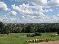
Haringey has 600 acres (2.4 km2) of parks, recreation grounds and open spaces[15] which make up more than 25% of its total area.[5] They include both smaller local areas and large green areas which provide an amenity for Londoners beyond the borough's boundaries. Local Nature Reserves and a number of conservation areas can also be found in the borough. The borough is also home to five distinct ancient woods. These are Highgate Woods, Queen's Wood, Coldfall Wood, Bluebell Wood and North Wood.[16]
The borough has achieved Green Flag status for 25 of its parks, meaning they are judged to be welcoming, safe and well-managed, with active community involvement.[17]
Amongst the larger open spaces are: Finsbury Park, Alexandra Park, Highgate Wood, Coldfall Wood and the Lee Valley Park.
There are three rivers of note still flowing above ground in the borough. These are:
- River Moselle
- The New River
- River Lea
Districts
There are a large number of districts within the borough. For a complete list see List of districts in Haringey.
Demographics
| Population | ||
|---|---|---|
| Year | Pop. | ±% |
| 1801 | 2,448 | — |
| 1811 | 4,481 | +83.0% |
| 1821 | 5,373 | +19.9% |
| 1831 | 6,201 | +15.4% |
| 1841 | 7,571 | +22.1% |
| 1851 | 8,762 | +15.7% |
| 1861 | 34,651 | +295.5% |
| 1871 | 60,541 | +74.7% |
| 1881 | 86,431 | +42.8% |
| 1891 | 158,596 | +83.5% |
| 1901 | 204,226 | +28.8% |
| 1911 | 263,009 | +28.8% |
| 1921 | 279,928 | +6.4% |
| 1931 | 297,936 | +6.4% |
| 1941 | 283,737 | −4.8% |
| 1951 | 270,214 | −4.8% |
| 1961 | 254,541 | −5.8% |
| 1971 | 239,833 | −5.8% |
| 1981 | 202,641 | −15.5% |
| 1991 | 211,633 | +4.4% |
| 2001 | 216,510 | +2.3% |
| 2011 | 254,926 | +17.7% |
| Source: A Vision of Britain through time | ||
According to the GLA's population projections for 2018, the current population of Haringey is 282,904 residents.
Haringey is the 6th most deprived borough in London, and the 30th most deprived local authority in England (out of 326). Within the borough there are extreme contrasts:[4] neighbourhoods in some of the western wards, such as Highgate, Muswell Hill and Crouch End are among the most prosperous in the country; in the east of the borough, many neighbourhoods are classified as being among the most deprived in the country.[5]
The population grew by 17.7% between the 2001 and 2011 Censuses, and is projected to have grown by a further 11% between 2011 and 2018.
The male to female ratio in Haringey is 50:50. While the age structure is similar to that of London, the borough has a slightly larger proportion of residents aged 20–44, and a slightly smaller proportion of residents aged 65+.
According to the GLA Population Estimate for 2018, 33.6% of the borough's population are White British, 25.9% are "Other White", 8.2% are of Black African heritage, and 5.8% are of Black Caribbean heritage. Haringey is also home to several smaller Asian communities.
Ethnicity
| Ethnic Group | 2001[18] | 2011[19] | ||
|---|---|---|---|---|
| Number | % | Number | % | |
| White: British | 98,028 | 45.3% | 88,424 | 34.7% |
| White: Irish | 9,302 | 4.3% | 6,997 | 2.7% |
| White: Gypsy or Irish Traveller | 370 | 0.1% | ||
| White: Other | 34,752 | 16.1% | 58,552 | 23.0% |
| White: Total | 142,082 | 65.7% | 154,343 | 60.5% |
| Asian or Asian British: Indian | 6,171 | 2.9% | 5,945 | 2.3% |
| Asian or Asian British: Pakistani | 2,046 | 0.9% | 1,920 | 0.8% |
| Asian or Asian British: Bangladeshi | 2,961 | 1.4% | 4,417 | 1.7% |
| Asian or Asian British: Chinese | 2,444 | 1.1% | 3,744 | 1.5% |
| Asian or Asian British: Other Asian | 3,348 | 1.5% | 8,124 | 3.2% |
| Asian or Asian British: Total | 16,970 | 7.8% | 24,150 | 9.5% |
| Black or Black British: African | 20,570 | 12.0% | 23,037 | 11.4% |
| Black or Black British: Caribbean | 19,879 | 10.3% | 18,087 | 7.8% |
| Black or Black British: Other Black | 2,928 | 2.4% | 6,706 | 3.9% |
| Black or Black British: Total | 43,377 | 20.1% | 47,830 | 18.7% |
| Mixed: White and Black Caribbean | 3,205 | 1.5% | 4,856 | 1.9% |
| Mixed: White and Black African | 1,551 | 0.7% | 2,609 | 1.0% |
| Mixed: White and Asian | 2,329 | 1.1% | 3,738 | 1.5% |
| Mixed: Other Mixed | 2,761 | 1.3% | 5,345 | 2.1% |
| Mixed: Total | 9,846 | 4.6% | 16,548 | 6.5% |
| Other: Arab | 2,229 | 0.9% | ||
| Other: Any other ethnic group | 4,232 | 2.0% | 9,286 | 3.9% |
| Other: Total | 4,232 | 2.0% | 12,055 | 5.3% |
| Black, Asian, and minority ethnic: Total | 74,425 | 34.5% | 100,583 | 39.5% |
| Total | 216,507 | 100.00% | 254,926 | 100.00% |
Housing
There are approximately 114,313 dwellings in Haringey. Of those: 43% are owner occupied; 29% are rented from the local authority or a housing association; and 24% are rented from a private landlord.
The local council and housing associations provide just over 27,000 affordable homes. As of Q4 2017 there were 3,002 households living in temporary accommodation in Haringey.
Wards

There are 19 wards in Haringey. Although they bear the names of long-established local areas, many have boundaries which do not exactly match the locally-understood boundaries of those areas.
The wards are:[20]
|
|
|
|
Politics
Since its creation, Haringey has always been a Labour borough, except during the three years following the Conservative landslide of 1968.
The Conservatives won that election by 53 seats to Labour's 7.[21]
Times, however, have certainly changed, and no Conservative candidate has won a local government seat in Haringey since 1998. In fact the only Conservative presence on the Council during this time was the 10 months that former Mayor, Cllr Alan Dobie spent sitting as a Conservative following his defection after being deselected in July 2009.[22]
For several years, Haringey Council was the subject of nationwide criticism over its handling of the welfare of young children, in connection with the murder of Victoria Climbié and the death of Baby P.[4] George Meehan, Council leader at the time of both the Victoria Climbie inquiry and the death of Baby P, resigned after a "damning" examination of Social Services caused by the Baby P case. He and Liz Santry, cabinet member for Children's Services, initially refused to resign at a Full Council meeting. All Labour Councillors voted for them to remain in their posts. Sharon Shoesmith, who was sacked on 8 December 2008 without any compensation package over the Baby P affair, was successful in her case of unfair dismissal and received compensation from the council.[23] Cllr Claire Kober became leader of Haringey Council on 10 December 2008.
In March 2009, the council's overall performance was assessed in an Audit Commission review as among the fourth worst in the whole country, and the worst in London.[24] Its previous three stars were reduced to one.
From a majority of only 3 in 2006, Labour increased their majority to 11 at the May 2010 local elections, winning 34 seats to the Liberal Democrats' 23. In the May 2014 local elections, Labour went on to make significant gains, particularly in the West of the borough, gaining seats as far west as Muswell Hill and Fortis Green.[25]
In the local elections of May 2014 Labour substantially increased its majority up to 39[26] seats over the Liberal Democrats, ahead by 48 seats to 9. That dominance was extended in August 2016, when former opposition leader, Cllr Sarah Elliott,[27] crossed the floor to join Labour. This was the third time that Haringey Lib Dem Councillors had crossed to Labour, following the defections of councillors Catherine Harris and Ali Demirci late in 2007. In January 2010, Brian Haley became the first ever Haringey Labour councillor to defect to the Liberal Democrats.
In November 2017, Haringey hit the headlines again [28] with bitter recriminations following hard fought selection battles for candidacies for Labour seats at the 2018 Council election. In an unprecedented change, 23 of the 49 sitting Labour Councillors either retired, decided not to stand after losing a trigger ballot, or were deselected as candidates from their seats by Labour Party members.
The media highlighted a number of reasons for this change including a poisonous attitude in the local party,[29] the influence of Momentum,[30] the impact of the Haringey Development Vehicle,[31] and the expressed will of the local members.[32]
In May 2018 the Liberal Democrats increased their representation on the council from 8 to 15, controlling the wards of Crouch End, Highgate, Fortis Green, Alexandra, and Muswell Hill. Group leader Liz Morris was quoted as saying that Labour had failed to win the "hearts and minds of residents",[33] but Labour retained the majority of seats on the council.
At the Annual General Meeting of the Council on 24 May 2018, Cllr Joseph Ejiofor was elected as Leader of the Council, Cllr Emina Ibrahim as Deputy Leader, and Cllr Gina Amadou as Mayor of Haringey.
Seats on Haringey Council, by party:[34]
| Year | Conservative | Labour | Liberal Democrats |
|---|---|---|---|
| 1994 | 2 | 57 | 0 |
| 1998 | 2 | 54 | 3 |
| 2002 | 0 | 42 | 15 |
| 2006 | 0 | 30 | 27 |
| 2007 | 0 | 32 | 25 |
| 2009 | 1 | 31 | 25 |
| 2010 | 1 | 30 | 26 |
| 2010 | 0 | 34 | 23 |
| 2014 | 0 | 48 | 9 |
| 2018 | 0 | 42 | 15 |
(Boundary changes in 2002 reduced the number of councillors by 2)
Economy
In 2016, there were 12,150 businesses in Haringey employing a total of 66,000 people. This accounted for 1.3% of all employment in London.
Haringey's economy is dominated by small businesses with 93.9% of businesses employing fewer than 10 people.
The main sectors of employment in Haringey are:
|
|
- Source[35]
The principal shopping areas in the borough are Wood Green and Turnpike Lane, Muswell Hill, Crouch End, Harringay and Tottenham Hale.
Haringey is situated within the growth corridor connecting London with Stansted, Cambridge and Peterborough.[36]
Culture
The borough has a number of facilities offering a wide range of cultural activity
Performing arts
Haringey's theatres include:
- Haringey Shed - an outreach theatre group of Chicken Shed Theatre.[37]
- Jacksons Lane - a multi-arts centre with a full-time programme of theatre and participatory events.
- New London Performing Arts Centre[38] provides affordable, accessible drama, dance, singing and music classes to children of all ages
- Bernie Grant Arts Centre.[39]
- Upstairs at the Gatehouse, Highgate
- Downstairs at the King's Head[40]
- A wide range of small live music venues together with the bigger venues of Finsbury Park and Alexandra Palace.
Visual arts
- The Chocolate Factory[41]
Education
Haringey has 64 primary (including infant and junior) schools, 11 secondary schools, a City Academy, 5 special schools and a pupil support centre. In addition, there are off site provision and study support centres for children and young people with additional needs [42].
The number of pupils in Haringey Schools as at January 2017 was 41,550 (including nursery age children). This total was made up as follows:
- Primary (state-funded) 23,735 (pupils of compulsory school age).
- Secondary (state-funded) 13,377 (including sixth form students).
- Special School pupils and students 485 (including post 16 children).
In 2014 Haringey Council contacted OFSTED and the police after video footage emerged showing multiple incidents where primary age children at the Harris Primary Academy Coleraine Park, in Tottenham, were physically restrained or "dragged around", each by either two or three members of staff. An executive from the National Association of Head Teachers described it as "horrible" to see a "really distressed" child restrained in this way. The school's policy requires any use of restraint to be notified to the parents in writing, but this had not happened. The school issued a statement saying that physical restraint is only used when pupils present a risk to themselves or others, and that it can make it possible for them to continue in mainstream education rather than being permanently excluded.[43]
Sport
Tottenham Hotspur Football Club, currently in the FA Premier League, play at Tottenham Hotspur Stadium, which is located in the borough on Tottenham High Road. The borough also has two Non-League football clubs, Haringey Borough F.C. and Greenhouse London F.C., who both play at Coles Park.
London Skolars are a rugby league team that compete in Kingstone Press League 1. They play at New River Stadium in Wood Green, Haringey. The annual Middlesex 9s rugby league tournament also takes place at the New River Stadium.
The borough's ice hockey team, the Haringey Greyhounds, currently play at Alexandra Palace. Alexandra Palace has also hosted other events including the PDC World Darts Championship and a number of Boxing events.
During the 1970s, 80s and 90s, the Haringey Athletic Club were at the forefront of a new generation of inner city athletes producing many Olympians. They have since been amalgamated into the Enfield and Haringey Athletic Club. London Heathside, formed in 2000 following the merger of North London AC and Muswell Hill Runners, are also based at the London Marathon Athletics Track at Finsbury Park.
Climbié Case
The local authority is Haringey London Borough Council. Haringey Council has been the subject of nationwide criticism over its handling of the welfare of young children in connection with the murder of Victoria Climbié in 2000 and the death of Peter Connelly in 2007.[4] In March 2009, Haringey Council's performance was placed by the Audit Commission in the bottom four of the country and the worst in London.[24] In December 2009, Haringey's performance was placed by Ofsted in the bottom nine in the country for children's services.[44] A later series of positive Ofsted inspections culminated in the service being taken out of 'special measures' by the government in February 2013.[45]
Transport
The 16 National Rail, London Overground and London Underground stations in the borough are:
- Alexandra Palace
- Bounds Green (London Underground)
- Bowes Park
- Bruce Grove
- Harringay Green Lanes
- Harringay
- Highgate (London Underground)
- Hornsey
- Manor House (London Underground)
- Northumberland Park
- Seven Sisters (National Rail and London Underground)
- South Tottenham
- Tottenham Hale (National Rail and London Underground)
- Turnpike Lane (London Underground)
- White Hart Lane
- Wood Green (London Underground)
In March 2011, the main forms of transport that residents used to travel to work were: underground, metro, light rail, tram, 23.5% of all residents aged 16–74; driving a car or van, 11.3%; bus, minibus or coach, 11.3%; train, 4.7%; on foot, 4.1%; work mainly at or from home, 3.6%; bicycle, 3.2%.[46]
Twin towns
Haringey has been twinned with Koblenz, Germany since 1969.[47] It has also twinned with the towns of:
Notable current and former residents
References and notes
- 2011 Census: Ethnic group, local authorities in England and Wales, Office for National Statistics (2012). See Classification of ethnicity in the United Kingdom for the full descriptions used in the 2011 Census.
- It is interesting to note that pupils in local schools at the time the borough was created in 1965 were taught that the new borough's name should be pronounced with the ending sounded as in the endings of Finchley, Hackney or Hornsey - Valerie Crosby, Archivist, Bruce Castle Archives, London Borough of Haringey, 2007
- London Borough of Haringey website, Facts & Figures Archived 15 December 2007 at the Wayback Machine
- "The rotten borough of Haringey? | News". Thisislondon.co.uk. Archived from the original on 1 August 2009. Retrieved 15 September 2010.
- Office for National Statistics
- Madge, Stephen J. (1938). The Early Records of Harringay alias Hornsey. Public Libraries Committee Hornsey.
- T. F. T. Baker & C. R. Elrington (Editors) (1985). A History of the County of Middlesex, Volume 8: Islington and Stoke Newington Parishes. British History Online].CS1 maint: extra text: authors list (link)
- Historic England. "Haringey Civic Centre (1454719)". National Heritage List for England. Retrieved 10 December 2018.
- Harringay is an area of London within the London Borough Haringey. The two differently spelt words describe different places and they are not interchangeable.
- "Coat of Arms | Haringey Council". www.haringey.gov.uk. Retrieved 30 January 2018.
- Civic Heraldry of England and Wales: Haringey lb
- "Coat of Arms". London Borough of Haringey. Archived from the original on 6 May 2006. Retrieved 23 December 2013.
- Jonathan Dixon (31 August 2006). "London (England): Haringey". Flags of the World. Flags of the World. Retrieved 22 December 2013.
- "The Mayoral Regalia". www.sheilapeacock.co.uk. Official homepage of former Mayor Sheila Peacock. Retrieved 22 December 2013.
- London Borough of Haringey Website - Open Spaces Page
- "The Natural History of Haringey, David Bevan". Muswell-hill.com. 31 March 1992. Retrieved 15 September 2010.
- English Heritage - Green Heritage Microsite
- "KS006 - Ethnic group". NOMIS. Retrieved 30 January 2016.
- "Ethnic Group by measures". NOMIS. Retrieved 8 January 2016.
- London Borough of Haringey Website Ward Profiles
- "London local elections 1968" (PDF). Retrieved 13 December 2017.
- Pears, Elizabeth (8 July 2009). "Tories reclaim Haringey Council seat following shock defection by Labour councillor Alan Dobbie". Haringey Independent. Newsquest Media Group. Retrieved 8 July 2009.
- "Baby P: The Untold Story - BBC One". BBC. Retrieved 11 August 2017.
- "Borough at centre of Baby P row ranked the worst in London | News". Thisislondon.co.uk. Retrieved 15 September 2010.
- "Labour make substantial gains". Retrieved 13 December 2017.
- "Haringey Council elections 2014". Retrieved 13 December 2017.
- "Former Lib Dem leader Cllr Sarah Elliott joins Labour". Retrieved 13 December 2017.
- "The battle for control of Haringey Council". Retrieved 13 December 2017.
- "Haringey Councillors deselected". Retrieved 13 December 2017.
- "HDV Councillors purged". Retrieved 13 December 2017.
- "HDV is the real issue of selection battle". Retrieved 13 December 2017.
- "Haringey selections are about people power". Retrieved 13 December 2017.
- Taylor, Harry (4 May 2018). "Local Elections 2018: Labour keep control of Haringey with Lib Dems making gains". Ham & High. Retrieved 5 May 2018.
- A graph showing the vote share by party from 1964 to 2010 is available on local website Harringay Online.
- Haringey's economic profile Archived 15 February 2008 at the Wayback Machine
- Audit Commission's Corporate Assessment of Haringey Council, October 2006
- "Haringey Shed". Haringey Shed. Retrieved 15 September 2010.
- "New London Performing Arts Centre - Home". Nlpac.co.uk. Retrieved 15 September 2010.
- "Bernie Grant Arts Centre | home". Berniegrantcentre.co.uk. Retrieved 15 September 2010.
- "downstairs at the king's head, comedy, music, performance". Downstairsatthekingshead.com. Retrieved 15 September 2010.
- JaiOnline.net. "About us". Chocolate Factory Artists. Archived from the original on 18 August 2016. Retrieved 15 September 2010.
- https://www.haringey.gov.uk/children-and-families/childcare-and-early-years/childrens-centres#haringey_children's_centres
- Ashdown, Mark (21 March 2014). "Concern over Tottenham primary school restraint footage". BBC News. Retrieved 22 March 2014.
- London Evening Standard 9 December 2009
- "Facts concerning Haringey Council's Children's Services": Haringey Council. Haringey.gov.uk (3 May 2012). Retrieved on 2013-08-13.
- "2011 Census: QS701EW Method of travel to work, local authorities in England and Wales". Office for National Statistics. Retrieved 23 November 2013. Percentages are of all residents aged 16-74 including those not in employment. Respondents could only pick one mode, specified as the journey’s longest part by distance.
- M/S-VisuCom GmbH. "Koblenz Tourism Website". Koblenz.de. Retrieved 15 September 2010.
- "Twinning of London Borough of Haringey with Holetown: 10 December 2009" (PDF). (13 KB) – Barbados Ministry of Foreign Affairs and Foreign Trade
- "Twinning Of London Borough Of Haringey With Holetown". Gisbarbados.gov.bb. 10 December 2009. Retrieved 15 September 2010.
External links
- Key statistics on Haringey on London Councils website
- Key leadership information on Haringey Council on the London Councils website
- Alexandra Palace
- Harringay Online - independent website for Harringay Neighbourood, but used throughout the borough
- Haringey Greyhounds Ice Hockey Club
- Haringey London Borough Council - History
- Haringey Freecycle group
- Haringey Council Report, Knowing Our Children And Young People - Planning For Their Futures
- Haringey Rhinos RFC
| Districts |
|  |
|---|---|---|
| Attractions |
| |
| Parks and open spaces |
| |
| Constituencies |
| |
| Tube and railway stations |
| |
| Other topics |
| |
| ||