Kaveri
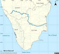
Kaveri (also known as Cauvery, the anglicized name), is an Indian river flowing through the states of Karnataka and Tamil Nadu. The Kaveri river rises at Talakaveri on the Brahmagiri range in the Western Ghats, Kodagu district of the state of Karnataka, at an elevation of 1341m above mean sea level and flows for about 800 km before its outfall into the Bay of Bengal. It is the third largest river – after Godavari and Krishna – in South India and the largest in Tamil Nadu which, on its course, bisects the state into North and South. The Kaveri is sacred river to the people of South India and is worshipped as the goddess Kaveriamma. The Kaveri is also one of the seven holy rivers of India.
| Kaveri Cauvery | |
|---|---|
 Map of the Cauvery river basin | |
| Native name | ಕಾವೇರಿ |
| Location | |
| Country | India |
| State | Karnataka, Tamil Nadu |
| Region | South India |
| Physical characteristics | |
| Source | Talakaveri, Kodagu, Western Ghats, Karnataka |
| ⁃ location | Karnataka, India |
| ⁃ coordinates | 12°23′N 75°29′E |
| ⁃ elevation | 1,276 m (4,186 ft) |
| Mouth | Bay of Bengal |
⁃ location | Poompuhar, Tamil Nadu |
⁃ coordinates | 11°21′40″N 79°49′46″E |
⁃ elevation | 0 m (0 ft) |
| Length | 805 km (500 mi)[1] |
| Basin size | 81,155 km2 (31,334 sq mi) |
| Discharge | |
| ⁃ average | 677 m3/s (23,900 cu ft/s) |
| Discharge | |
| ⁃ location | Grand Anicut (South)[2] |
| ⁃ average | 400.716 m3/s (14,151.2 cu ft/s) |
| Basin features | |
| Tributaries | |
| ⁃ left | Harangi, Hemavati, Shimsha, Arkavathy |
| ⁃ right | Lakshmana Tirtha, Kabini, Bhavani, Noyyal, Amaravati, Moyar |
The catchment area of Kaveri basin is estimated to be 81,155 square kilometres (31,334 sq mi) with many tributaries including Harangi, Hemavati, Kabini, Bhavani, Lakshmana Tirtha, Noyyal and Arkavati. The river basin covers three states and a Union Territory as follows: Tamil Nadu, 43,868 square kilometres (16,938 sq mi); Karnataka, 34,273 square kilometres (13,233 sq mi); Kerala, 2,866 square kilometres (1,107 sq mi), and Puducherry, 148 square kilometres (57 sq mi).[3] Rising in Talakaveri in Kodagu, Karnataka, it flows southeast some 800 kilometres (500 mi) to enter the Bay of Bengal. In Chamarajanagar district it forms the island of Shivanasamudra, on either side of which are the scenic Shivanasamudra Falls that descend about 100 metres (330 ft).[4] The river is the source for an extensive irrigation system and for hydroelectric power.[5] The river has supported irrigated agriculture for centuries and served as the lifeblood of the ancient kingdoms and modern cities of South India. Access to the river's waters has pitted Indian states against each other for decades. It was profusely described in the Tamil Sangam literature and is held in great reverence in Hinduism.
River course
After the river leaves the Kodagu hills and flows onto the Deccan plateau, it forms two islands in Mandya district's Srirangapatna and Shivanasamudra. First comes the Srirangapatna, which forms the sangam, and then comes Shivanasamudra. At Shivanasamudra the river drops 98 metres (320 ft), forming the famous Shivanasamudra Falls known separately as Gagana Chukki and Bhara Chukki.[6] Asia's first hydroelectric plant (built in 1902) was on the left falls and supplied power to the city of Bangalore.
In its course through Karnataka, the channel is interrupted by 12 "anekattu" (dams) for the purpose of irrigation. From the Anaikattu at Madadkatte, an artificial channel is diverted at a distance of 116 kilometres (72 mi), irrigating an area of 4,000 hectares (10,000 acres), and ultimately bringing its water supply to the town of Mandya.
Three kilometres away from Srirangapatna, the Kaveri is the basis for the Ranganthittu Bird Sanctuary. Near Srirangapatna is also an aqueduct, the Bangara Doddi Nala, which was constructed in the 17th century by the Wodeyar maharaja of Mysore, Ranadhira Kantirava, in memory of his favourite consort. This aqueduct also served as a motorable bridge until 1964.The kabini river tributary of Kaveri joins Kaveri at Tirumakudal Narasipura where triveni sangama takes place along with mythological river Spatika. The Moyar River is an east flowing river that originates in the Mudumalai, Bandipur, and Wayanad National Parks draining the Nilgiri Hills in Tamil Nadu and Karnataka and is one of the tributaries to the Kaveri River.
The river enters Tamil Nadu through Dharmapuri district leading to the flat plains where it meanders. It drops into the Hogenakkal Falls just before it arrives in the town of Hogenakkal in Tamil Nadu. The three minor tributaries, Palar, Chinnar and Thoppar enter into the Kaveri on her course, above Stanley Reservoir in Mettur, where the dam has been constructed. It then flows further through the length of Erode district where the river Bhavani, running through the breadth of the district, merges with it. The confluence of the rivers Kaveri, Bhavani and Akash Ganga (mythological) is at the exact place of Bhavani, Tamil Nadu Kooduthurai or Tiriveni Sangamam, Northern part of Erode City.
While passing through Erode, two more tributaries merge. Thirumani Mutharu joins it in a village called Kududurai in Namakkal District. Noyyal and Amaravathi join it in Karur district before it reaches Tiruchirapalli district. Here the river becomes wide, with a sandy bed, and flows in an eastern direction until it splits into two at upper Anicut about 14 kilometres (9 mi) west of Tiruchirappalli. The northern branch of the river is called the Kollidam while the southern branch retains the name Kaveri and then goes directly eastwards into Thanjavur District. These two rivers join again and form the Srirangam island that is a part of the city of Tiruchirapalli. The oldest functional dam[7]Grand Anicut or Kallanai was present at this place. From Thanjavur, the river splits and goes to few places in the Delta Kaveri.
Tributaries
- Harangi River
- Hemavati River
- Lakshmana Tirtha
- Amaravathi River
- Bhavani River
- Kabini River
- Noyyal River
Irrigation
The primary uses of Kaveri is providing water for irrigation, water for household consumption and the generation of electricity.
An estimate at the time of the first Five Year Plan puts the total flow of the Kaveri at 15 cubic kilometres (12,000,000 acre⋅ft), of which 60 percent was used for irrigation. [8]
The Torekadanahalli pumpstation sends 540 million litres (19,000,000 cu ft) per day of water from Kaveri 100 kilometres (62 mi) to Bangalore.[9][10]
The hydroelectric plant built on the left of Sivanasamudra Falls on the Kaveri in 1902 was the first hydroelectric plant in Asia.[4]
The Krishna Raja Sagara Dam has a capacity of 49 tmc ft.[11] and the Mettur Dam which creates Stanley Reservoir has a capacity of 93.4 tmc ft. (thousand million cubic ft)
In August 2003, inflow into reservoirs in Karnataka was at a 29-year low, with a 58% shortfall.[12] Water stored in Krishna Raja Sagara amounted to only 4.6 tmc ft.[12]
In February 2020, Tamil Nadu assembly passed bill to declare Cauvery Delta as Protected Agricultural Zone, includes Thanjavur, Thirvarur, Nagapattinam and five blocks in Cuddalore and Pudukottai. The bill fails to include Tiruchirappalli, Ariyalur and Karur which are geographically included in the Cauvery Delta.[13]
Water sharing
As per an order by the Indian Supreme Court on 16 February 2018,[14] Karnataka will get 284.75 tmc ft, Tamil Nadu will get 404.25 tmc ft, Kerala will get 30 tmc ft and Puducherry will get 7 tmc ft, 10 tmc ft will be reserved for Environmental Protection and 4 tmc ft will be reserved for Inevitable Wastage into the Sea.[15]
Cauvery Water Management Authority (CWMA) and Cauvery Water Regulation Committee (CWRC) 2018
Acting on the Supreme Court's direction, the Centre constituted a Cauvery Water Management Authority (CMA) on 1 June 2018 to address the dispute over sharing of river water among Tamil Nadu, Karnataka, Kerala and Puducherry.[16]
On 16 February 2018, the apex court had directed the government to form the CMA within six weeks in a verdict that marginally increased Karnataka's share of Cauvery water, reduced the allocation for Tamil Nadu and sought to settle the protracted water dispute between the two sout.[17]
On 22 June 2018, Despite opposition from Karnataka, the Central government constituted the Kaveri Water Regulation Committee as per the provisions in the Kaveri Management Scheme laid down by the Supreme Court.[18]
Central Water Commission chairman, S. Masood Hussain will head the CWMA and chief engineer of the Central Water Commission, Navin Kumar will be the first chairman of the CWRC. While the CWMA is an umbrella body, the CWRC will monitor water management on a day-to-day basis, including the water level and inflow and outflow of reservoirs in all the basin states.[18]
See also
- List of rivers of India
- Kaveri Pushkaram
References
- "INTEGRATED HYDROLOGICAL DATA BOOK" (PDF). Central Water Commission, India. p. 92. Archived from the original (PDF) on 2 April 2016. Retrieved 13 November 2017.
- "Gauging Station - Data Summary". RivDis. Archived from the original on 4 October 2013. Retrieved 1 October 2013.
- "INTEGRATED HYDROLOGICAL DATA BOOK" (PDF). Retrieved 6 September 2012.
- "World Waterfall Database". Archived from the original on 14 November 2006. Retrieved 9 November 2006.
- "Shivasamudram Falls". cauvery.com. Retrieved 11 November 2006.
- The Cauvery Trail : Kaveri has many religious and tourism spots between KRS and Mettur Archived 2 July 2014 at the Wayback Machine
- http://www.water-technology.net/features/feature-the-worlds-oldest-dams-still-in-use/
- "Chapter 26: Irrigation and power". 1st Five Year Plan. Planning Commission, Government of India. Archived from the original on 28 March 2019. Retrieved 1 July 2019.
- "PINCHme: Try products from leading brands for FREE!".
- http://www.tce.co.in/infra/watersupply/bangalore.pdf#search=%22halli%20pipeline%20Bangalore%22%5B%5D
- "Corporation urged to chalk out water policy for Mysore city". The Hindu. Chennai, India. 26 March 2006.
- "Cauvery reservoirs' inflow hits record low". Deccan Herald. Bangalore. 2 August 2003. Archived from the original on 6 April 2012. Retrieved 18 March 2011.
- https://www.theweek.in/news/india/2020/02/20/tn-assembly-passes-bill-to-declare-cauvery-delta-as-protected-ag.html
- "Archived copy" (PDF). Archived from the original (PDF) on 17 April 2018. Retrieved 24 July 2018.CS1 maint: archived copy as title (link)
- "Judgement Copy- SC verdict on Cauvery water dispute". Scribd.
- "Cauvery Water Management Scheme, 2018". Department of Water Resources, RD & GR.
- Rajagopal, Krishnadas (16 February 2018). "Supreme Court curtails Tamil Nadu's share of Cauvery water". The Hindu. ISSN 0971-751X. Retrieved 2 December 2019.
- "Cauvery dispute". www.thenewsminute.com. Retrieved 2 December 2019.
External links
| Wikimedia Commons has media related to Kaveri. |
- Cauvery Presentation on the Cavery River
- Kaveri Pushkaralu
- Kaveri Pushkaram 2017