Sutlej
The Sutlej River (alternatively spelled as Satluj River) (Sanskrit: शतद्रु नदी Shatadru nadee; Hindi: सतलज नदी satalaj nadee; Punjabi: سَتلٌڄ; Urdu: دریائے ستلُج ; darya-e-sutlej) is the longest of the five rivers that flow through the historic crossroads region of Punjab in northern India and Pakistan. The Sutlej River is also known as Satadree.[2] It is the easternmost tributary of the Indus River.
| Sutlej / Satluj शतद्रु/ सतलज नदी/ ਸਤਲੁਜ /ستلُج / ستلُج | |
|---|---|
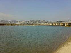 River Sutlej in Rupnagar, Punjab, India | |
 Path of the Sutlej | |
| Location | |
| Country | China, India, Pakistan |
| State | Tibet, Himachal Pradesh, Punjab, Bahawalpur district, Punjab |
| Physical characteristics | |
| Source | Langqên Zangbo |
| ⁃ location | Tibet |
| ⁃ coordinates | 30°50′39″N 81°12′17″E |
| ⁃ elevation | 4,575 m (15,010 ft) |
| Mouth | Confluence with Chenab to form the Panjnad River |
⁃ location | Bahawalpur district, Punjab, Pakistan |
⁃ coordinates | 29°23′23″N 71°3′42″E |
⁃ elevation | 102 m (335 ft) |
| Length | 1,500 km (930 mi)approx. |
| Basin size | 395,000 km2 (153,000 sq mi)approx. |
| Discharge | |
| ⁃ location | Ropar[1] |
| ⁃ average | 500 m3/s (18,000 cu ft/s) |
| Basin features | |
| Tributaries | |
| ⁃ left | Baspa |
| ⁃ right | Spiti, Beas |
The waters of the Sutlej are allocated to India under the Indus Waters Treaty between India and Pakistan, and are mostly diverted to irrigation canals in India.[3] The mean annual flow is 14 million acre feet (MAF) in the upstream of Ropar barrage located across the Sutlej River downstream of Bhakra dam.[4] There are several major hydroelectric projects on the Sutlej, including the 1,325 MW Bhakra Dam, the 1,000 MW Karcham Wangtoo Hydroelectric Plant, and the 1,500 MW Nathpa Jhakri Dam.[5] The river basin area in India is located in Himachal Pradesh, Punjab, Jammu and Kashmir and Haryana states.[6][7]
Sources
The source of the Sutlej is west of catchment area of the Lake Rakshastal in Tibet, as springs in an ephemeral stream. Lake Rakshastal used to be part of the Sutlej river basin long ago and separated from the Sutlej due to tectonic activity. The nascent river flows at first west-northwest for about 260 kilometres (160 mi) under the Tibetan name Langqên Zangbo (Elephant River or Elephant Spring) to the Shipki La pass, entering India in Himachal Pradesh state. It then turns slightly, heading west-southwest for about 360 kilometres (220 mi) to meet the Beas River near Makhu, Firozpur district, Punjab state. Ropar Wetland in Punjab state is located on the Sutlej river basin. Evidence suggests Indus Valley Civilisation also flourished here. Ungti Chu and Pare Chu rivers which drain southeastern part of Jammu and Kashmir state are tributaries of Sutlej river.[8][7]
Continuing west-southwest, the Sutlej enters Pakistan about 15 kilometres (9.3 mi) east of Bhedian Kalan, Kasur District, Punjab province, continuing southwest to water the ancient and historical former Bahawalpur princely state. Few centuries ago, Sutlej river was merging with the Ghaggar river to discharge in to the Arabian sea. In 1797 the course of the Sutlej river moved towards north to join the Beas river.[9]
About 17 kilometres (11 mi) north of Uch Sharif, the Sutlej unites with the Chenab River, forming the Panjnad River, which finally flows into the Indus river about 100 kilometres (62 mi) west of the city of Bahawalpur. The area to the southeast on the Pakistani side of the Indian border is called the Cholistan Desert and, on the Indian side, the Thar Desert.
The Indus then flows through a gorge near Sukkur and the fertile plains region of Sindh, forming a large delta region between the border of Gujarat, India and Pakistan, finally terminating in the Arabian Sea near the port city of Karachi, Pakistan. During floods, Indus river water flows in to Indian part of Great Rann of Kutch. Thus Gujarat state of India is also a riparian state of Indus river as Rann of Kutch area lying west of Kori Creek in the state is part of the Indus River Delta.[10]
Langqên Zangbo
| Langqên Zangbo 朗钦藏布 | |
|---|---|
 | |
| Native name | གླང་ཆེན་གཙང་པོ |
| Location | |
| Country | Tibet |
| State | Tibet |
| Region | Ngari Prefecture |
| Physical characteristics | |
| Source | |
| ⁃ location | Tibet |
| Length | 309 km (192 mi) |
| Basin features | |
| River system | Sutlej |
Langqên Zangbo (Tibetan: གླང་ཆེན་གཙང་པོ, Wylie: glang chen gtsang po ; Chinese: 朗钦藏布; pinyin: Lăngqīn Zàngbù) is a river in Ngari, Tibet, China. The name Langqên, Tibetan for "elephant", is because of a valley that resembles an elephant trunk. This river is the main source of the Sutlej, a tributary of Indus River. It enters India at Shipki La pass. The source is south of Gangdise Range, in Ngari Prefecture. Its course is mainly in the Zanda County. The river drains an area of 22,760 km2, and covers a length of 309 km. The drop in height is 3,256 m. Historically, the river was the centre of the Zhangzhung Kingdom until its fall in the 8th century AD.
Geology
The Sutlej, along with all of the Punjab rivers, is thought to have drained east into the Ganges prior to 5 mya.[11]
There is substantial geologic evidence to indicate that prior to 1700 BC, and perhaps much earlier, the Sutlej was an important tributary of the Ghaggar-Hakra River (thought to be the legendary Sarasvati River) rather than the Indus, with various authors putting the redirection from 2500 to 2000 BC,[12] from 5000 to 3000 BC,[13] or before 8000 BC.[14] Geologists believe that tectonic activity created elevation changes which redirected the flow of Sutlej from the southeast to the southwest.[15] If the diversion of the river occurred recently (about 4000 years ago), it may have been responsible for the Ghaggar-Hakra (Saraswati) drying up, causing desertification of Cholistan and the eastern part of the modern state of Sindh, and the abandonment of Harappan settlements along the Ghaggar. However, the Sutlej may have already been captured by the Indus thousands of years earlier.
There is some evidence that the high rate of erosion caused by the modern Sutlej River has influenced the local faulting and rapidly exhumed rocks above Rampur.[16] This would be similar to, but on a much smaller scale than, the exhumation of rocks by the Indus River in Nanga Parbat, Pakistan. The Sutlej River also exposes a doubled inverted metamorphic gradient.[17]
Sutlej-Yamuna Link
There has been a proposal to build a 214-kilometre (133 mi) long heavy freight and irrigation canal, to be known as the Sutlej-Yamuna Link (SYL) to connect the Sutlej and Yamuna rivers.[18] The project is intended to connect the Ganges, which flows to the east coast of the subcontinent, with points west, via Pakistan. When completed, the SYL would enable inland shipping from India's east coast to its west coast (on the Arabian sea) without having to round the southern tip of India by sea, vastly shortening shipping distances, alleviating pressures on seaports, avoiding sea hazards, creating business opportunities along the route, raising real estate values, raising tax revenue, and establishing important commercial links and providing jobs for north-central India's large population. However, the proposal has met with obstacles and has been referred to the Supreme Court of India. To augment nearly 100 tmcft water availability for the needs of this link canal, Tso Moriri lake/Lingdi Nadi (a tributary of Tso Moriri lake) waters can be diverted to the Sutlej basin by digging a 10 km long gravity canal to connect to the Ungti Chu river.[7][19]
History
The Upper Sutlej Valley, called Langqên Zangbo in Tibet, was once known as the Garuda Valley by the Zhangzhung, the ancient civilization of western Tibet. The Garuda Valley was the centre of their empire, which stretched many miles into the nearby Himalayas. The Zhangzhung built a towering palace in the Upper Sutlej Valley called Kyunglung, the ruins of which still exist today near the village of Moincêr, southwest of Mount Kailash (Mount Ti-se). Eventually, the Zhangzhung were conquered by the Tibetan Empire.
Today, the Sutlej Valley is inhabited by nomadic descendants of the Zhangzhung, who live in tiny villages of yak herders.
The Sutlej was the main medium of transportation for the kings of that time. In the early 18th century, it was used to transport devdar woods for Bilaspur district, Hamirpur district, and other places along the Sutlej's banks.
Of four rivers (Indus, Sutlej, Brahmaputra and Karnali/Ganges) mythically flowing out of holy Lake Manasarovar, the Sutlej is actually connected by channels that are dry most of the time. Earlier the river was also called as Shutudri or Zaradros river.[20]
Gallery
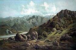
- Sutlej Valley from Rampur c. 1857
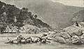 Using inflated animal skins to cross the Sutlej River, c. 1905
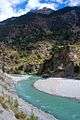 Sutlej River in Kinnaur Valley, Himachal Pradesh, India
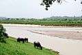 Cattle grazing on the banks of the river in Rupnagar, Punjab, India
 Satluj River near Shahkot, Punjab, India
%2C_from_the_Illustrated_London_News%2C_1856.jpg) Sutlej entering India from Tibet near Shipki La, c. 1856
Sutlej entering India from Tibet near Shipki La, c. 1856
See also
- List of rivers of India
- List of rivers of Pakistan
- Cis-Sutlej states
- Sulemanki Headworks
- Geology of the Himalaya
References
- "Sutlej valley". The Free Dictionary.
- Asiatic Society of Bengal (1848). Journal of the Asiatic Society of Bengal, Volume 17, Part 1. p. 210, paragraph two.
- Archived 31 August 2005 at the Wayback Machine
- "Page 290, The Ravi- Beas Water Tribunal Report (1987)" (PDF). Central Water Commission. Retrieved 15 February 2020.
- "Nathpa Jhakri Hydroelectric Power Project, India". power-technology.com. Retrieved 14 May 2011.
- "Lower Sutlej basin area" (PDF). Retrieved 14 May 2017.
- "WRIS geo-visualization map". Retrieved 17 January 2017.
- "Upper Sutlej basin area" (PDF). Retrieved 14 May 2017.
- "Page 60, The Ravi- Beas Water Tribunal Report (1987)" (PDF). Central Water Commission. Retrieved 15 February 2020.
- "Evolution of the Delta, the LBOD outfall system and the Badin dhands - chapters 3 & 4" (PDF). Retrieved 22 December 2015.
- Clift, Peter D.; Blusztajn, Jerzy (15 December 2005). "Reorganization of the western Himalayan river system after five million years ago". Nature. 438 (7070): 1001–1003. doi:10.1038/nature04379. PMID 16355221.
- Mughal, M. R. Ancient Cholistan. Archaeology and Architecture. Rawalpindi-Lahore-Karachi: Ferozsons 1997, 2004
- Valdiya, K. S., in Dynamic Geology, Educational monographs published by J. N. Centre for Advanced Studies, Bangalore, University Press (Hyderabad), 1998.
- K.S. Valdiya. 2013. "The River Saraswati was a Himalayan-born river". Current Science 104 (01).
- Thiede, Rasmus; Arrowsmith, J. Ramón; Bookhagen, Bodo; McWilliams, Michael O.; Sobel, Edward R.; Strecker, Manfred R. (August 2005). "From tectonically to erosionally controlled development of the Himalayan orogen". Geology. 33 (8): 689–692. doi:10.1130/G21483AR.1.
- Grasemann, Bernhard; Fritz, Harry; Vannay, Jean-Claude (July 1999). "Quantitative kinematic flow analysis from the Main Central Thrust Zone) NW-Himalaya, India: implications for a decelerating strain path and the extrustion of orogenic wedges". Journal of Structural Geology. 21 (7): 837–853. doi:10.1016/S0191-8141(99)00077-2.
- http://india.gov.in/sectors/water_resources/sutlej_link.php Sutlej-Yamuna Link
- "Harnessing gigantic hydro power potential of Indus, Jhelum and Chenab rivers by diverting water to Ravi and Sutlej rivers in India". Retrieved 13 January 2017.
- https://www.britannica.com/place/Sutlej-River
External links
| Wikimedia Commons has media related to Sutlej River. |
- Sutlej basin marked on OpenStreetMap.
Hydrography of Himachal Pradesh | |
|---|---|
| Rivers |
|
| Lakes |
|
| Dams, Barrages |
|
| Related topics/ templates |
|
| Hydrography of surrounding areas |
|