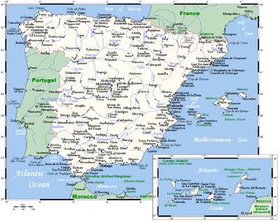
Geography of Spain
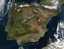
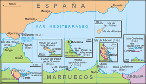
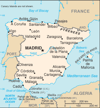
Spain is a country located in southwestern Europe occupying most (about 82 percent) of the Iberian Peninsula. It also includes a small exclave inside France called Llívia, as well as the Balearic Islands in the Mediterranean, the Canary Islands in the Atlantic Ocean 108 km (67 mi) off northwest Africa, and five places of sovereignty (plazas de soberanía) on and off the coast of North Africa: Ceuta, Melilla, Islas Chafarinas, Peñón de Alhucemas, and Peñón de Vélez de la Gomera.
 | |
| Continent | Europe |
|---|---|
| Region | Southern Europe Iberian Peninsula |
| Coordinates | 1,917.8 km (1,191.7 mi) [nortagaltugal]]: 1,214 km (754 mi) France: 623 km (387 mi) Andorra: 63.7 km (39.6 mi) Morocco (Melilla): 9.6 km (5.97 mi) Morocco (Ceuta): 6.3 km (3.91 mi) Gibraltar: 1.2 km (0.75 mi) |
| Highest point | Teide (Canary Islands) 3,718 m (12,198 ft) Mulhacén (Iberian Peninsula) 3,477 m (11,407 ft) |
| Lowest point | Atlantic Ocean, Mediterranean Sea 0 m (0 ft) (Sea level) |
| Longest river | Tagus |
| Largest lake | Lago de Sanabria |
| Exclusive economic zone | 1,039,233 km2 (401,250 sq mi) |
The Spanish mainland is bordered to the south and east almost entirely by the Mediterranean Sea (except for the small British territory of Gibraltar); to the north by France, Andorra, and the Bay of Biscay; and to the west by the Atlantic Ocean and Portugal. With a land area of 504,782 square kilometres (194,897 sq mi) in the Iberian peninsula,[1] Spain is the largest country in Southern Europe, the second largest country in Western Europe (behind France), and the fourth largest country in the European continent (behind Russia, Ukraine, and France). It has an average altitude of 650 m.
Its total area including Spanish island territories is 505,370 km2 (195,124 sq mi) of which 499,542 km2 (192,874 sq mi) is land and 5,240 km2 (2,023 sq mi) is water.[2] It has the 30th largest Exclusive Economic Zone of 1,039,233 km2 (401,250 sq mi). Spain lies between latitudes 27° and 44° N, and longitudes 19° W and 5° E. Its Atlantic coast is 710 km (441 mi) long. The Pyrenees mountain range extends 435 km (270 mi) from the Mediterranean to the Bay of Biscay. In the extreme south of Spain's mainland lie the Straits of Gibraltar, which separate the Iberian peninsula and the rest of Europe from Ceuta and Morocco in North Africa.
External boundaries and landform regions
Water boundaries
Most of Spain's boundaries are water: the Mediterranean Sea along the east from the French border down to Gibraltar and the Strait of Gibraltar, which can be divided into the Balearic Sea along the northern stretch, and the Alboran Sea in the southern sector, and the Atlantic Ocean on the northwest and southwest (in the south as the Golfo de Cádiz or Gulf of Cádiz and in the north as the Mar Cantábrico or Bay of Biscay). The Spanish autonomous cities of Ceuta and Melilla are Spanish enclaves lying in mainland Africa in territory claimed by Morocco, are located on the coast of the Alboran Sea, with Ceuta at the very mouth of the Strait of Gibraltar, and Melilla closer to the border with Algeria. The Canary Islands, geographically and geologically part of the African continent, are washed by the Atlantic Ocean.
Spain also shares land boundaries with France and Andorra along the Pyrenees in the northeast, with Portugal on the west, with the small British colonial Territory of Gibraltar near the southernmost tip, and with Morocco in its autonomous cities of Ceuta and Melilla, and certain other small but uninhabited enclaves, mostly capes and small isles. The affiliation of Gibraltar has continued to be a contentious issue between Spain and Britain, whereas the sovereignty of Spain's enclaves, or plazas de soberanía, on the Mediterranean coast of Morocco is disputed by Morocco.
Spain also has a small exclave inside France called Llívia, which is a mountain village in the historical comarca of La Cerdanya, forming part of the historical territories of Catalonia.
Peninsular Region
The majority of Spain's peninsular region consists of the Meseta Central, a highland plateau rimmed and dissected by mountain ranges. Other landforms include narrow coastal plains and some lowland river valleys, the most prominent of which is the Andalusian Plain in the southwest. The country can be divided into ten natural regions or subregions: the dominant Meseta Central, the Cantabrian Mountains (Cordillera Cantabrica) and the northwest region, the Ibérico region, the Pyrenees, the Penibético region in the southeast, the Andalusian Plain, the Ebro Basin, the coastal plains, the Balearic Islands, and the Canary Islands. These are commonly grouped into four types: the Meseta Central and associated mountains, other mountainous regions, lowland regions, and islands.
The Inner Plateau and associated mountains
The Meseta Central ("Inner Plateau") is a vast plateau in the heart of peninsular Spain, which has elevations that range from 610 to 760 m. Rimmed by mountains, the Meseta Central slopes gently to the west and to the series of rivers that form some of the border with Portugal. The Sistema Central, described as the "dorsal spine" of the Meseta Central, divides the Meseta into northern and southern subregions, the former higher in elevation and smaller in area than the latter. The Sistema Central rims the capital city of Madrid with peaks that rise to over 2,400 m within the Madrid region. South-west of Madrid, the Sistema Central shows its highest peak, Pico Almanzor, of 2,592 m. The mountains of the Sistema Central, which continue westward into Portugal, display some glacial features; the highest of the peaks are snow-capped for most of the year. Despite their height, however, the mountain system does not create a major barrier between the northern and the southern portions of the Meseta Central because several passes permit road and railroad transportation to the northwest and the northeast.
The southern portion of the Meseta (Spanish: Submeseta Sur) is further divided by twin mountain ranges, the Montes de Toledo running to the east with the Sierra de Guadalupe, to the west. Their peaks do not rise much higher than 1,500 m. With many easy passes, including those that connect the Meseta with the Andalusian Plain, the Montes de Toledo do not present an obstacle to transportation and communication. This chain of lower mountain ranges is separated from the Sistema Central to the north by the longest river in the Iberian Peninsula: the Tagus River.
The mountain regions that rim the Meseta Central and are associated with it are the Sierra Morena, the Cordillera Cantábrica, and the Sistema Ibérico. Forming the southern edge of the Meseta Central, the Sierra Morena merges in the east with the southern extension of the Sistema Iberico and reaches westward along the northern edge of the Rio Guadalquivir valley to join the mountains in southern Portugal. The massif of the Sierra Morena extends northward to the Río Guadiana, which separates it from the Sistema Central. Despite their relatively low elevations, seldom surpassing 1,300 m, the mountains of the Sierra Morena are rugged at their southern edge.
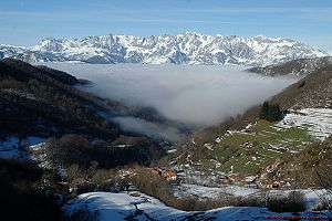
The Cordillera Cantábrica, a limestone formation, runs parallel to, and close to, the northern coast near the Bay of Biscay. Its highest points are the Picos de Europa, surpassing 2,600 m. The Cordillera Cantábrica extends 182 km and abruptly drops 1,500 m some 30 km from the coast. To the west lie the hills of the northwest region and to the east the Basque mountains that link them to the Pyrenees.
The Sistema Ibérico extends from the Cordillera Cantábrica southeastward and, close to the Mediterranean, spreads out from the Río Ebro to the Río Júcar. The barren, rugged slopes of this mountain range cover an area of close to 21,000 square kilometers. The mountains exceed 2,000 m in their northern region and reach a maximum height of over 2,300 m east of the headwaters of the Rio Duero. The extremely steep mountain slopes in this range are often cut by deep, narrow gorges.
Lowland regions
The major lowland regions are the Andalusian Plain in the southwest, the Ebro Basin in the northeast, and the coastal plains. The Andalusian Plain is essentially a wide river valley through which the Río Guadalquivir flows. The river broadens out along its course, reaching its widest point at the Golfo de Cadiz. The Andalusian Plain is bounded on the north by the Sierra Morena and on the south by the Sistema Penibético; it narrows to an apex in the east where these two mountain chains meet. The Ebro Basin is formed by the Río Ebro valley, contained by mountains on three sides—the Sistema Ibérico to the south and west, the Pyrenees to the north and east, and their coastal extensions paralleling the shore to the east. Minor low-lying river valleys close to the Portuguese border are located on the Tagus and the Río Guadiana.
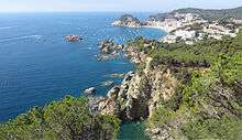
The Coastal Plains regions are narrow strips between the coastal mountains and the seas. They are broadest along the Golfo de Cádiz, where the coastal plain adjoins the Andalusian Plain, and along the southern and central eastern coasts. The narrowest coastal plain runs along the Bay of Biscay, where the Cordillera Cantábrica ends close to shore.

The islands
The remaining regions of Spain are the Balearic and the Canary Islands, the former located in the Mediterranean Sea and the latter in the Atlantic Ocean. The Balearic Islands, encompassing a total area of 5,000 square kilometers, lie 80 kilometers off Spain's central eastern coast. The mountains that rise up above the Mediterranean Sea to form these islands are an extension of the Sistema Penibetico. The archipelago's highest points, which reach 1,400 meters, are in northwestern Mallorca, close to the coast. The central portion of Majorca is a plain, bounded on the east and the southeast by broken hills.
The Canary Islands, ninety kilometers off the west coast of Africa, are of volcanic origin. The large central islands, Tenerife and Gran Canaria, have the highest peaks. Pico de Las Nieves, on Gran Canaria, rises to 1,949 meters, and the Teide, on Tenerife, to 3,718 meters. Teide, a dormant volcano, is the highest peak of Spain and the third largest volcano in the world from its base.
Drainage, floods, and water stress
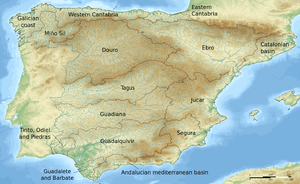
Of the roughly 1,800 rivers and streams in Spain, only the Tagus is more than 960 kilometers long; all but 90 extend less than 96 kilometers. These shorter rivers carry small volumes of water on an irregular basis, and they have seasonally dry river beds; however, when they do flow, they often are swift and torrential. Most major rivers rise in the mountains rimming or dissecting the Meseta Central and flow westward across the plateau through Portugal to empty into the Atlantic Ocean. One significant exception is the river with the most abundant flow in Spain, the Ebro, which flows eastward to the Mediterranean. Rivers in the extreme northwest and in the narrow northern coastal plain drain directly into the Atlantic Ocean. The northwestern coastline is also truncated by rias, waterbodies similar to fjords.[3]
The major rivers flowing westward through the Meseta Central include the Duero, the Tagus, the Guadiana, and the Guadalquivir. The Rio Guadalquivir is one of the most significant rivers in Spain because it irrigates a fertile valley, thus creating a rich agricultural area, and because it is navigable inland, making Seville the only inland river port for ocean-going traffic in Spain. The major river in the northwest region is the Miño.[4]
El Atazar Dam is a major dam built near Madrid to provide a water supply.
Floods and erosion
Certain Spanish regions can be considered vulnerable to both flooding and erosion.[5]
Water stress
Water stress or water lack, poses the greatest threat in Spain. Water scarcity is a significant issue in many regions throughout Spain and climate change may aggravate the problem, with longer periods of dry weather. Supply problems regularly occur in the Jucar basin during summer. In the Segura basin, water scarcity has resulted in an increase of the water prices by 30% for households. Overall, the regions in the south-east of Spain are particularly vulnerable to water shortages. Furthermore, large areas of the Mediterranean are affected by saltwater intrusion.[5]
Climate
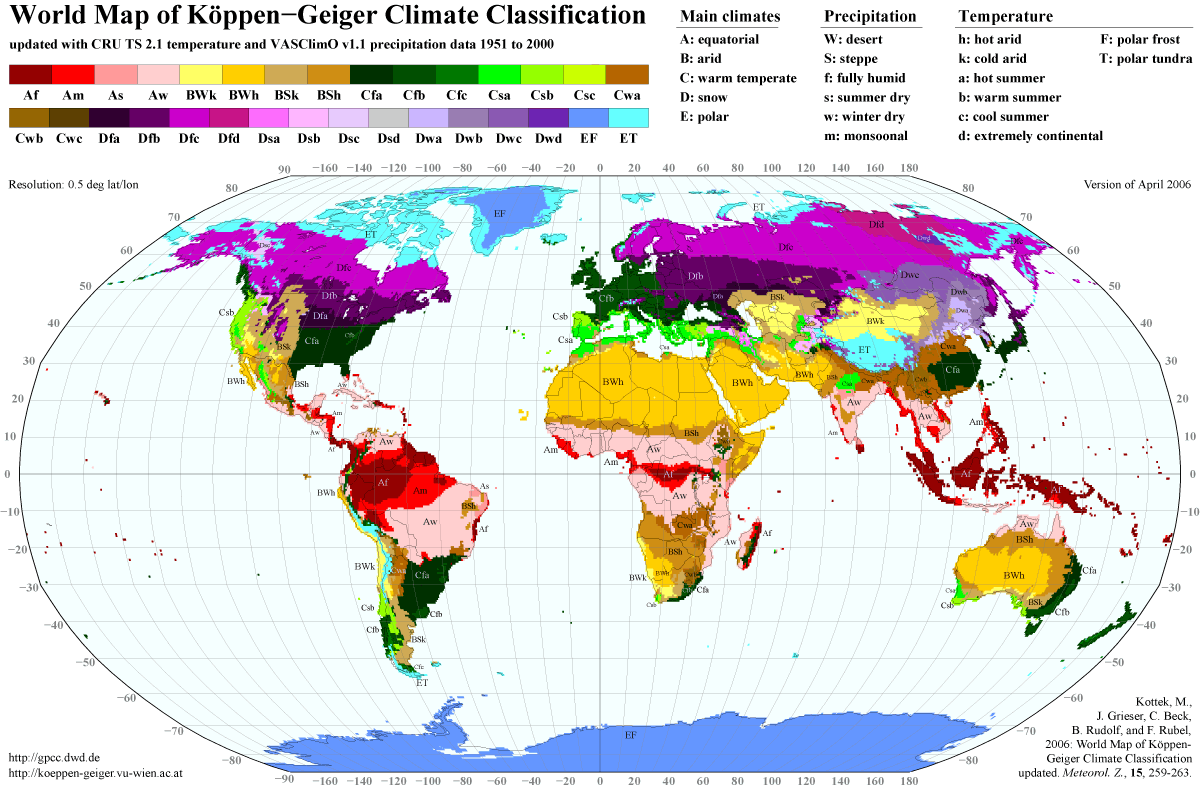
Three main climatic zones can be separated, according to geographical situation and orographic conditions:[8][9][10][11]
- The Mediterranean climate, characterized by dry and warm summers. According to the Köppen climate classification, it is dominant in the peninsula, with two varieties: Csa and Csb.
- The semiarid climate (Bsh, Bsk), located in the southeastern quarter of the country, especially in the region of Murcia and in the Ebro valley. In contrast with the Mediterranean climate, the dry season extends beyond the summer.
- The oceanic climate (Cfb), is located in the northern quarter of the country, especially in the regions of Basque Country, Asturias, Cantabria and partly Galicia. In contrary to the Mediterranean climate, winter and summer temperatures are influenced by the ocean.
Apart from these main types, other sub-types can be found, like the desertic climate in parts of southeastern Spain, like in coastal Almería. Humid continental, alpine and tundra climates in the Pyrenees and Sierra Nevada, and a typical subtropical climate in the Canary Islands, varying from humid subtropical climates to desertic climates in most of the islands, and a tropical hot semi-arid climate in coastal parts, such as Tenerife or Gran Canaria.
Population geography
Largest cities by population
- Madrid 3,300,000
- Barcelona 1,582,000
- Valencia-València 798,000
- Sevilla 710,000
- Zaragoza 626,081
- Málaga 547,000
- Murcia 447,000
- Las Palmas 378,000
- Palma 367,000
- Bilbao-Bilbo 354,000
- Córdoba 326,000
- Valladolid 321,000
- Alicante-Alacant 306,000
- Vigo 293,000
- Gijón-Xixón 271,000
- Hospitalet de Llobregat-L'Hospitalet de Llobregat 246,000
- A Coruña-La Coruña 244,000
- Granada 238,000
- Vitoria-Gasteiz 223,000
- Santa Cruz de Tenerife 220,000
- Badalona 214,000
- Oviedo-Uviéu 208,000
- Elche-Elx 207,000
- Móstoles 202,000
- Terrassa-Tarrasa 200,000
- Pamplona-Iruña 199,000
Biggest metropolitan areas

The largest metropolitan areas, based on 2007 population, were:[12]
- Madrid 5,603,000
- Barcelona 4,667,000
- Valencia 1,671,000
- Sevilla 1,294,000
- Bilbao 951,000
- Málaga 898,000
- Asturias (Gijón-Oviedo) 857,000
- Alicante-Elche 749,000
- Zaragoza 732,000
- Vigo 662,412
- Las Palmas 617,000
- Bahía de Cádiz (Cádiz-Jerez de la Frontera) 615,000
- Santa Cruz de Tenerife 574,000
- Murcia 563,000
- Palma de Mallorca 474,000
- Granada 473,000
- San Sebastián 402,000
- Tarragona 406,000
- A Coruña 403,000
- Valladolid 400,000
- Santander - Torrelavega 391,000
- Córdoba 324,000
- Pamplona-Iruña 309,631
Resources and land use
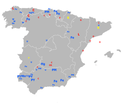
Natural resources: coal, lignite, iron ore, uranium, mercury, pyrites, fluorspar, gypsum, zinc, lead, tungsten, copper, kaolin, potash, sepiolite, hydropower, arable land
Land use:
- Arable land: 27.18%
- Permanent crops: 9.85%
- Other: 62.97% (2005)
Irrigated land: 38,000 km2 (2003)
Total renewable water resources: 111.1 cubic metres (2005)
Freshwater withdrawal (domestic/industrial/agricultural):
- total: 37.22 cu km/yr (13%/19%/68%)
- per capita: 864 cu m/yr (2002)
Environmental concerns
Natural hazards: periodic droughts, occasional flooding
Environment – Current Issues:
- Pollution of the Mediterranean Sea from raw sewage and effluents from the offshore production of oil and gas; water quality and quantity nationwide; air pollution; deforestation; desertification
Environment – International Agreements:
- Party to: Air Pollution, Air Pollution-Nitrogen Oxides, Air Pollution-Sulphur 94, Air Pollution-Volatile Organic Compounds, Antarctic-Environmental Protocol, Antarctic Treaty, Biodiversity, Climate Change, Climate Change-Kyoto Protocol, Desertification, Endangered Species, Environmental Modification, Hazardous Wastes, Law of the Sea, Marine Dumping, Marine Life Conservation, Ozone Layer Protection, Ship Pollution, Tropical Timber 83, Tropical Timber 94, Wetlands, Whaling
- Signed, but not ratified: Air Pollution-Persistent Organic Pollutants
Maritime claims
- Contiguous zone: 24 nmi (44.4 km; 27.6 mi)
- Exclusive economic zone: 1,039,233 km2 (401,250 sq mi) with 200 nmi (370.4 km; 230.2 mi) (applies only to the Atlantic Ocean)
- Territorial sea: 12 nmi (22.2 km; 13.8 mi)
See also
- Autonomous communities of Spain
- Comarcas of Spain
- Extreme points of Spain
- Provinces of Spain
Notes
- The surface of the islands will be given in hectares except for the largest islands of the Canary and Balearic archipelagos, as well as the Plazas de soberanía.
References
Citations
- Eur (30 November 2002). Western Europe 2003. Psychology Press. p. 559. ISBN 978-1-85743-152-0.
- "Spain". The World Factbook. Central Intelligence Agency. 2008. Retrieved 2008-12-09.
- "Spain - Rivers". countrystudies.us. Retrieved 2017-10-05.
- Lagasse, Paul, ed. (2018). The Columbia Encyclopedia (8th ed.). Columbia University: Columbia University Press – via Credo Reference.
- http://ec.europa.eu/maritimeaffairs/documentation/studies/documents/spain_en.pdf
- Hasta aquí llegó la riada, ABC, 13 August 2007
- Diluvio en el País Valenciano, La Vanguardia, 21 October 1982, p1
- "Atlas Climático Ibérico – Iberian Climate Atlas" (PDF). 2011. Retrieved 2011-10-18. Agencia Estatal de Meteorología © (Espana). Ministerio de Medio Ambiente y Medio Rural y Marino © (Espana). Instituto de Meteorologia de Portugal ©.
- "World Map of the Köppen-Geiger climate classification updated – (see p.3)" (PDF). Retrieved 2011-04-30.
- http://www.city-data.com/forum/attachments/weather/56180d1263187925-ultimate-climate-poll-koppen-climate-classification-kottek_et_al_2006.gif
- "Archived copy". Archived from the original on April 30, 2011. Retrieved January 1, 2013.CS1 maint: archived copy as title (link)
- Ruiz, Francisco (2007). "Población de las áreas urbanas y metropolitanas". Población de España – datos y mapas (in Spanish). Alarcos Research Group. Archived from the original (xls) on 2009-02-03. Retrieved 2008-12-10.
Sources

External links
- Loyd, Nick (2007). "IberiaNature: A guide to the environment, climate, wildlife, geography and nature of Spain". Retrieved 2008-12-04.
- Data Spain: Satellite relief maps, aerial photography, outline maps, travel maps and useful themed maps of Spain
- Virtual Cadastral: Lookup official Spanish property (catastro) deeds and other Spanish property information: exact map location, altitude, land area, and distances.
Spain articles | |||||||
|---|---|---|---|---|---|---|---|
| History |
|  | |||||
| Geography |
| ||||||
| Politics |
| ||||||
| Economy |
| ||||||
| Society |
| ||||||
| |||||||