Tagus
The Tagus (/ˈteɪɡəs/ TAY-gəs; Spanish: Tajo [ˈtaxo]; Portuguese: Tejo [ˈtɛʒu]; see below) is the longest river in the Iberian Peninsula. It is 1,007 km (626 mi) long, 716 km (445 mi) in Spain, 47 km (29 mi) along the border between Portugal and Spain and 275 km (171 mi) in Portugal, where it empties into the Atlantic Ocean near Lisbon. It drains an area of 80,100 square kilometers (30,927 sq mi) (the second largest in the Iberian peninsula after the Douro). The Tagus is highly utilized for most of its course. Several dams and diversions supply drinking water to places of central Spain and Portugal, while dozens of hydroelectric stations create power. Between dams it follows a very constricted course, but after Almourol it enters a wide alluvial valley, prone to flooding. Its mouth is a large estuary near the port city of Lisbon.
| Tagus | |
|---|---|
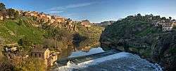 View of Tagus River in Toledo, Spain | |
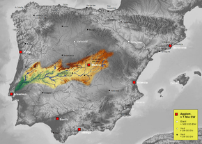
 Path of the Tagus through the Iberian Peninsula | |
| Etymology | Vulgar Latin taliāre, "to cut through" |
| Location | |
| Country | Spain, Portugal |
| Physical characteristics | |
| Source | Fuente de García |
| ⁃ location | Montes Universales, Sierra de Albarracín Comarca, Teruel, Aragon, Spain |
| ⁃ elevation | 1,593 m (5,226 ft) |
| Mouth | Estuary of the Tagus |
⁃ location | Atlantic Ocean near Lisbon, Portugal |
⁃ elevation | 0 m (0 ft) |
| Length | 1,007 km (626 mi) |
| Basin size | 80,100 km2 (30,900 sq mi) |
| Discharge | |
| ⁃ average | 500 m3/s (18,000 cu ft/s) |
| Basin features | |
| Tributaries | |
| ⁃ left | Guadiela, Algodor, Gévalo, Ibor, Almonte, Salor, Sever |
| ⁃ right | Gallo, Jarama, Guadarrama, Alberche, Tiétar, Alagón, Zêzere |
.jpg)
The source of the Tagus is the Fuente de García in the Frías de Albarracín municipal term, Montes Universales, Sistema Ibérico, Sierra de Albarracín Comarca. All its major tributaries enter the Tagus from the right (north) bank. The main cities it passes through are Aranjuez, Toledo, Talavera de la Reina and Alcántara in Spain, and Abrantes, Santarém, Almada and Lisbon in Portugal.
Course
In Spain

The first notable city on the Tagus is Sacedón. Below Aranjuez it receives the combined flow of the Jarama, Henares, Algodor and Tajuña. Below Toledo it receives the Guadarrama River. Above Talavera de la Reina it receives the Alberche. At Valdeverdeja is the upper end of the long upper reservoir, the Embalse de Valdecañas, beyond which are the Embalse de Torrejon, into which flow the Tiétar, and the lower reservoir, the Alcántara Dam into which flows the Alagón at the lower end.
There is a canal and aqueduct between the Tagus and the Segura, the Tagus-Segura Water Transfer.
In Portugal
After forming the border it enters Portugal, passing Vila Velha de Ródão, Abrantes, Constância, Entroncamento, Santarém and Vila Franca de Xira at the head of the long narrow estuary, which has Lisbon at its mouth. The estuary is protected by the Tagus Estuary Natural Reserve. There is a large bridge across the river, the Vasco da Gama Bridge, which with a total length of 17.2 km (10.7 mi) is the second longest bridge in Europe. The Port of Lisbon, located at its mouth, is one of Europe's busiest.
The Portuguese Alentejo region and former Ribatejo Province take their names from the river; Alentejo, from além Tejo "Beyond the Tagus" and Ribatejo from arriba Tejo, an archaic way of saying "Upper Tagus".
In Spanish Riba means land beside a river or shore along of a river. Then Ribatejo should mean "The land beside the Tejo" or "The shore of the Tejo". One can see many examples of towns in Spain with this prefix.
Name
The river's Latin name Tagus [ˈtaɡʊs] is believed to derive from the Vulgar Latin verb taliāre, "to cut through", due to the way the river "cuts through" the Iberian terrain; the Italian tagliare ("to cut") is from the same root.[1] In the languages of Iberia:
- Basque: Tajo
- Catalan: Tajo
- Galician: Río Texo
- Mirandese: Riu Teijo
- Occitan: Tage
- Portuguese: Tejo
- Spanish: Tajo.
It is known in Italian as Tago and Greek as Τάγος (Tágos).
Geology
The lower Tagus is on a fault line. Slippage along it has caused numerous earthquakes, the major ones being those of 1309, 1531 and 1755.[2]
History

The Pepper Wreck, properly the wreck of the Nossa Senhora dos Mártires, is a shipwreck located and excavated at the mouth of the Tagus between 1996 and 2001.
The river had strategic value to the Spanish and Portuguese empires, as it guarded the approach to Lisbon. For example, in 1587, Francis Drake briefly approached the river after his successful raid at Cadiz.[3]
Popular culture
A major river, the Tagus is brought to mind in the songs and stories of the Portuguese. A popular fado song in Lisbon notes that while people get older, the Tagus remains young ("My hair getting white, the Tagus is always young"). The author, Fernando Pessoa, wrote a poem that begins:
- "The Tagus is more beautiful than the river that flows through my village. But the Tagus is not more beautiful than the river that flows through my village..."[4]
Richard Crashaw's poem "Saint Mary Magdalene, or the Weeper" refers to the "Golden" Tagus as wanting Mary Magdalene's silver tears. In classical poetry the Tagus was famous for its gold-bearing sands (Catullus 29.19, Ovid, Amores, 1.15.34, Juvenal, Satires, 3.55, etc.).
See also
- List of rivers of Spain
- List of rivers of Portugal
| Wikimedia Commons has media related to Tagus River. |
Notes
- "Origins of European rivers' names". www.eupedia.com.
- Hobbs, William Herbert (1907). Earthquakes: An Introduction to Seismic Geology. NewYork: D. Appleton and Company. pp. 142–144. Downloadable Internet Archive
- Garrett Mattingly (2005). The Armada. Houghton Mifflin Harcourt. pp. 118–119. ISBN 978-0618565917.
Tagus.
- Pessoa, Fernando; Richard Zenith, Translator (1999). Fernando Pessoa and Co.: Selected Poems. Grove Press. p. 55. ISBN 9780802136275.
| Authority control |
|
|---|