Zurobara
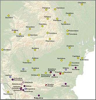
Zurobara (Ancient Greek: Ζουρόβαρα) was a Dacian town located in today's Banat region in Romania. It is positioned by the Tibiscus river (Timiș River), north of Zarmizegethusa Regia and south of Ziridava. It was near the Tisza river, in the area of the Dacian tribe of Biephi.[1][2]
 Zurobara on Dacia's map from a medieval book made after Ptolemy's Geographia (ca. 140 AD). | |
| Location | Romania |
|---|---|
| History | |
| Cultures | Biephi |
This town was attested by Ptolemy in his Geographia (III; 8; 4),[1] yet its exact location remains unknown. Zurobara is amongst the places, which are not to be found on the great Roman roads between the Tysis and the Aluta,[3]
Ancient sources
Ptolemy's Geographia
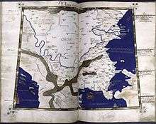
Zurobara is mentioned in Ptolemy's Geographia (c. 140 AD) in the form Ζουρόβαρα as an important town in western Dacia, at latitude 45° 40' N and longitude 45° 40' E[1][2] (note that he used a different meridian and some of his calculations were off). Ptolemy completed his work soon after Trajan's Dacian Wars, as a result of which parts of Dacia were incorporated into the Roman Empire as the new Dacia province.
Tabula Peutingeriana
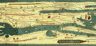
Unlike many other Dacian towns mentioned by Ptolemy, Zurobara is missing from Tabula Peutingeriana (1st–4th century AD), an itinerarium showing the cursus publicus, the road network in the Roman Empire.[4]
The Danish philologist and historian Gudmund Schütte believed that the town with similar name Ziridava, also mentioned by Ptolemy and also missing from Tabula Peutingeriana, was the same with Zurobara.[5] This idea is deemed erroneous alongside many other assumed duplications of names, by the Romanian historian and archaeologist Vasile Pârvan in his work Getica.[6] Pârvan reviewed all localities mentioned in Ptolemy's Geographia, analyzing and verifying all data available to him at the time. He points out that Ziri and Zuro (meaning water) are the roots of two different Geto-Dacian words.[7] Additionally, Ptolemy provided different coordinates for the two towns,[1][2] some medieval maps created based on his Geographia depict two distinct towns.
Etymology
Zurobara name (that could have been a spelling variant for Zuropara[8]) was interpreted initially as "strong city" where: the ending term of name "bara" / "vara" means ‘city’ (the same as Thracian "para") and the first term of the name "Zuro" means ‘strong’ . Zuro ‘strong’ is also found in the name of Zyraxes, a Dacian king,.[9][10]
Because of Proto-Indo-European "e" > Dacian "a" (cf. PIE *dhewa > Dacian dava, PIE *ser > Dacian sara), bara is rather derived from root *bher ‘rich, abundance’ and zura from root *ser, *sara ‘waters, river'. In this case, Zurobara meant ‘a waters abundance city’.[11]
Notes
- Ptolemy & 140 AD, III 8,4.
- Olteanu, Ptolemy's Dacia.
- Dictionary of Greek and Roman geography, Volume 1, edited by Sir William Smith, Boston, 1854
- Tabula Peutingeriana, Segmentum VIII,3.
- Schütte 1917, p. 91-93.
- Pârvan 1926, p. 252.
- Pârvan 1926, p. 253.
- Iorga (1937) 43-45
- “Les restes de la langue dace” by W. Tomaschek (Gratz University) in “Le Muséon (Revue Internationale Volume 2)”, Louvain, 1883 (page 402)
- Van Den Gheyn, S. J. (1930): Populations Danubiennes, Études D’ethnographie compareee in "Revue des questions scientifiques, Volumes 17-18, 1930" by "Société scientifique de Bruxelles, Union catholique des scientifiques français", ISSN 0035-2160
- Parvan (1926) 253
References
Ancient
- Anonymous. Tabula Peutingeriana (in Latin).
- Ptolemy, Claudius (1843) [c. 140 AD]. Geographia [Geography] (in Ancient Greek). Sumptibus et typis Caroli Tauchnitii.
Modern
- Iorga, Nicolae (1937). Histoire des Roumains et de la romanité orientale. Académie roumaine.
- Olteanu, Sorin. "Linguae Thraco-Daco-Moesorum - Ptolemy's Dacia". Linguae Thraco-Daco-Moesorum (in Romanian and English). Archived from the original on 3 March 2011. Retrieved 3 March 2011.
- Olteanu, Sorin. "Linguae Thraco-Daco-Moesorum - Toponyms Section". Linguae Thraco-Daco-Moesorum (in Romanian and English). Archived from the original on 3 January 2010. Retrieved 3 January 2010.
- Pârvan, Vasile (1926). Getica (in Romanian and French). București, Romania: Cvltvra Națională.CS1 maint: ref=harv (link)
- Schütte, Gudmund (1917). Ptolemy's maps of northern Europe: a reconstruction of the prototypes. Copenhagen: H. Hagerup.CS1 maint: ref=harv (link)
Further reading
- Olteanu, Sorin. "Linguae Thraco-Daco-Moesorum - Toponyms Section". Linguae Thraco-Daco-Moesorum (in Romanian and English). Archived from the original on 3 January 2010. Retrieved 3 January 2010.
External links
![]()
Dacia topics | |||||||||||||||||
|---|---|---|---|---|---|---|---|---|---|---|---|---|---|---|---|---|---|
| Tribes | |||||||||||||||||
| Kings | |||||||||||||||||
| |||||||||||||||||
Wars with the Roman Empire |
| ||||||||||||||||
| Roman Dacia |
| ||||||||||||||||
| Research |
| ||||||||||||||||
| |||||||||||||||||