Yan Ta Khao District
Yan Ta Khao District (Thai: ย่านตาขาว, pronounced [jâːn tāː kʰǎːw]) is a district (amphoe) of Trang Province, Thailand.
Yan Ta Khao ย่านตาขาว | |
|---|---|
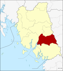 District location in Trang Province | |
| Coordinates: 7°23′12″N 99°40′0″E | |
| Country | Thailand |
| Province | Trang |
| Seat | Yan Ta Khao |
| Area | |
| • Total | 431.1 km2 (166.4 sq mi) |
| Population (2005) | |
| • Total | 61,416 |
| • Density | 142.5/km2 (369/sq mi) |
| Time zone | UTC+7 (ICT) |
| Postal code | 92140 |
| Geocode | 9203 |
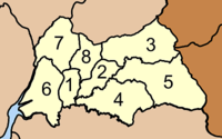
Geography
Neighboring districts are (from the south clockwise): Palian, Kantang, Mueang Trang and Na Yong of Trang Province; Srinagarindra and Kong Ra of Phatthalung Province.
History
The minor district (king amphoe) Yan Ta Khao was created on 1 January 1948 as a subordinate of Kantang District. Originally it consisted of six tambons: Yan Ta Khao, Nong Bo, and Thung Khai were split off from Kantang District, Na Chum Het from Mueang Trang District, and Nai Khuan and Phrong Chorakhe from Palian District.[1] It was upgraded to a full district on 5 June 1956.[2]
Administration
The district is divided into eight sub-districts (tambons), which are further subdivided into 65 villages (mubans). Yan Ta Khao is a township (thesaban tambon) which covers parts of tambon Yan Ta Khao. There are further eight tambon administrative organizations (TAO).
|
 |
References
- ประกาศกระทรวงมหาดไทย เรื่อง ยกฐานะตำบลขึ้นเป็นกิ่งอำเภอ (PDF). Royal Gazette (in Thai). 64 (60 ง): 3288–3293. December 9, 1947.
- พระราชกฤษฎีกาจัดตั้งอำเภอนาทวี อำเภอสะบ้าย้อย อำเภอคำชะอี อำเภอย่านตาขาว อำเภอวัดโบสถ์ อำเภอหนองบัว อำเภอวัฒนานคร อำเภอแสวงหา อำเภอท่าชนะ อำเภอพระพุทธบาท อำเภอโนนสัง อำเภอบำเหน็จณรงค์ อำเภอคอนสวรรค์ อำเภอบ้านโฮ่ง อำเภอคีรีมาศ อำเภอชนแดน อำเภอแม่แจ่ม อำเภอไทรน้อย และอำเภอบ้านแพง พ.ศ. ๒๔๙๙ (PDF). Royal Gazette (in Thai). 73 (46 ก): 657–661. June 5, 1956.