Woodland Beach, Michigan
Woodland Beach is a census-designated place (CDP) and unincorporated community in Monroe County in the U.S. state of Michigan. The population was 2,049 at the 2010 census.[3] The CDP is located within Frenchtown Charter Township.
Woodland Beach, Michigan | |
|---|---|
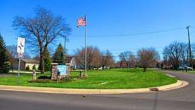 Woodland Beach along N. Dixie Highway | |
 Location within Monroe County | |
 Woodland Beach Location within the state of Michigan | |
| Coordinates: 41°56′24″N 83°18′48″W | |
| Country | United States |
| State | Michigan |
| County | Monroe |
| Township | Frenchtown |
| Area | |
| • Total | 0.52 sq mi (1.3 km2) |
| • Land | 0.52 sq mi (1.3 km2) |
| • Water | 0.0 sq mi (0 km2) |
| Elevation | 577 ft (176 m) |
| Population (2010) | |
| • Total | 2,049 |
| • Density | 3,940.4/sq mi (1,521.4/km2) |
| Time zone | UTC-5 (Eastern (EST)) |
| • Summer (DST) | UTC-4 (EDT) |
| ZIP code(s) | 48162 (Monroe) |
| Area code(s) | 734 |
| FIPS code | 26-88480[1] |
| GNIS feature ID | 1616752[2] |
Woodland Beach and its surrounding communities are served by Jefferson Schools.[4]
Geography
According to the United States Census Bureau, the CDP has a total area of 0.52 square miles (1.35 km2), all land.[3]
The CDP includes several lakefront community along the shores of Lake Erie, about 4 miles (6 km) northeast of the city of Monroe. The communities include Erie Shores, Grand Beach, Indian Trails, and Woodland Beach. The CDP stretches from South Grove Drive on the south to Stony Creek on the north. The majority of the CDP lies southeast of North Dixie Highway with a small portion of the Woodland Beach community extending northwest of North Dixie Highway. The CDP of Detroit Beach is adjacent to the southwest, and the CDP of Stony Point is about 3 miles (5 km) to the east.
Demographics
As of the census[1] of 2000, there were 2,179 people, 794 households, and 605 families residing in the CDP. The population density was 4,155.0 per square mile (1,617.9/km²). There were 831 housing units at an average density of 1,584.6 per square mile (617.0/km²). The racial makeup of the CDP was 98.12% White, 0.23% African American, 0.18% Native American, 0.09% from other races, and 1.38% from two or more races. Hispanic or Latino of any race were 0.87% of the population.
There were 794 households out of which 38.3% had children under the age of 18 living with them, 59.6% were married couples living together, 10.2% had a female householder with no husband present, and 23.8% were non-families. 20.3% of all households were made up of individuals and 7.2% had someone living alone who was 65 years of age or older. The average household size was 2.74 and the average family size was 3.15.
In the CDP, the population was spread out with 28.1% under the age of 18, 9.6% from 18 to 24, 32.5% from 25 to 44, 22.6% from 45 to 64, and 7.2% who were 65 years of age or older. The median age was 34 years. For every 100 females, there were 100.8 males. For every 100 females age 18 and over, there were 98.1 males.
The median income for a household in the CDP was $45,417, and the median income for a family was $47,212. Males had a median income of $36,296 versus $23,571 for females. The per capita income for the CDP was $17,824. About 7.2% of families and 7.1% of the population were below the poverty line, including 7.0% of those under age 18 and none of those age 65 or over.
References
- "U.S. Census website". United States Census Bureau. Retrieved 2008-01-31.
- U.S. Geological Survey Geographic Names Information System: Woodland Beach, Michigan
- "Michigan: 2010 Population and Housing Unit Counts 2010 Census of Population and Housing" (PDF). 2010 United States Census. United States Census Bureau. September 2012. p. 34 Michigan. Retrieved May 21, 2020.
- Michigan Department of Information Technology (31 Aug 2009). "Jefferson Schools (Monroe): Monroe ISD" (PDF). Retrieved April 2, 2020.
Municipalities and communities of Monroe County, Michigan, United States | ||
|---|---|---|
| Cities | 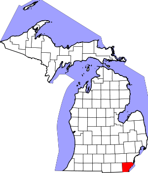 Map of Michigan highlighting Monroe County | |
| Villages | ||
| Charter townships | ||
| Civil townships | ||
| CDPs | ||
| Other unincorporated communities |
| |
| Ghost towns | ||
| Footnotes | ‡This populated place also has portions in an adjacent county or counties | |