Luna Pier, Michigan
Luna Pier is a city in Monroe County in the U.S. state of Michigan. It is located 6 miles (9.7 km) from the Ohio border along the coast of Lake Erie. Previously known as Lakewood,[6] it was established in the early 1900s and incorporated as a city in 1963.[7] It functioned primarily as a resort for people living in the greater Toledo, Ohio and Metro Detroit area. The population was 1,436 at the 2010 census.
Luna Pier, Michigan | |
|---|---|
| City of Luna Pier | |
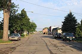 Facing west along Luna Pier Road | |
 Seal | |
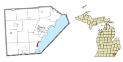 Location within Monroe County | |
 Luna Pier Location within the state of Michigan | |
| Coordinates: 41°48′25″N 83°26′33″W | |
| Country | United States |
| State | Michigan |
| County | Monroe |
| Incorporated | 1963 |
| Government | |
| • Type | Mayor–council |
| • Mayor | James Gardner |
| • Clerk | DeAnn Parran |
| Area | |
| • Total | 1.69 sq mi (4.37 km2) |
| • Land | 1.49 sq mi (3.86 km2) |
| • Water | 0.20 sq mi (0.51 km2) |
| Elevation | 574 ft (175 m) |
| Population | |
| • Total | 1,436 |
| • Estimate (2018)[3] | 1,410 |
| • Density | 945.71/sq mi (365.18/km2) |
| Time zone | UTC-5 (Eastern (EST)) |
| • Summer (DST) | UTC-4 (EDT) |
| ZIP code(s) | 48157 |
| Area code(s) | 734 |
| FIPS code | 26-49700[4] |
| GNIS feature ID | 0631215[5] |
| Website | Official website |
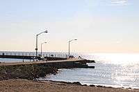
Its most prominent feature is a large crescent-shaped pier made of concrete, approximately 800 ft (240 m) long and reaching around 200 feet (61 m) out into Lake Erie. The pier is flanked by sandy beaches and man-made rock and concrete embankments. On most days, the Davis–Besse Nuclear Power Station in Port Clinton and Toledo Harbor Light can be seen from the pier. The city is served by Mason Consolidated Schools.
Geography
According to the United States Census Bureau, the city has a total area of 1.68 square miles (4.35 km2), of which 1.50 square miles (3.88 km2) is land and 0.18 square miles (0.47 km2) is water.[8]
Transportation
The city of Luna Pier is served by Interstate 75 (I-75), with connections north to Detroit and Flint (via I-275), and connections south to Toledo, Ohio.
Two roads go in and out of Luna Pier, one being Luna Pier Road, which runs west to US Highway 23 (US 23), US 24, and US 223. The other is Gaynier Road, which leads northwest out of town.
Luna Pier was formerly served by Canadian National Railway via BNSF-contracted coal trains that served the Consumers Energy J.R. Whiting Generating Plant, located on Erie Road south of Luna Pier. Trains to the plant ceased in late April 2016 following its closing.[9] Norfolk Southern Railway also has railroad tracks through the area, but does not serve any industries.
Demographics
| Historical population | |||
|---|---|---|---|
| Census | Pop. | %± | |
| 1970 | 1,418 | — | |
| 1980 | 1,443 | 1.8% | |
| 1990 | 1,507 | 4.4% | |
| 2000 | 1,483 | −1.6% | |
| 2010 | 1,436 | −3.2% | |
| Est. 2018 | 1,410 | [3] | −1.8% |
| U.S. Decennial Census[10] | |||
2010 census
As of the census[2] of 2010, there were 1,436 people, 608 households, and 373 families living in the city. The population density was 957.3 inhabitants per square mile (369.6/km2). There were 702 housing units at an average density of 468.0 per square mile (180.7/km2). The racial makeup of the city was 93.2% White, 0.8% African American, 0.8% Native American, 0.5% Asian, 1.1% from other races, and 3.5% from two or more races. Hispanic or Latino of any race were 3.0% of the population.
There were 608 households, of which 27.8% had children under the age of 18 living with them, 42.1% were married couples living together, 14.3% had a female householder with no husband present, 4.9% had a male householder with no wife present, and 38.7% were non-families. 32.9% of all households were made up of individuals, and 9.7% had someone living alone who was 65 years of age or older. The average household size was 2.36 and the average family size was 3.00.
The median age in the city was 41.7 years. 22.9% of residents were under the age of 18; 8.6% were between the ages of 18 and 24; 22% were from 25 to 44; 35.8% were from 45 to 64; and 10.5% were 65 years of age or older. The gender makeup of the city was 48.3% male and 51.7% female.
2000 census
As of the census[4] of 2000, there were 1,483 people, 592 households, and 406 families living in the city. The population density was 956.9 per square mile (369.4/km2). There were 661 housing units at an average density of 426.5 per square mile (164.7/km2). The racial makeup of the city was 95.48% White, 1.01% Native American, 0.94% from other races, 0.20% African American, and 2.36% from two or more races. Hispanic or Latino of any race were 3.03% of the population.
There were 592 households, out of which 35.3% had children under the age of 18 living with them, 50.2% were married couples living together, 10.5% had a female householder with no husband present, and 31.4% were non-families. 28.2% of all households were made up of individuals, and 12.0% had someone living alone who was 65 years of age or older. The average household size was 2.51 and the average family size was 3.05.
In the city, the population was spread out, with 29.2% under the age of 18, 6.3% from 18 to 24, 31.2% from 25 to 44, 24.2% from 45 to 64, and 9.2% who were 65 years of age or older. The median age was 36 years. For every 100 females, there were 98.5 males. For every 100 females age 18 and over, there were 98.1 males.
The median income for a household in the city was $40,909, and the median income for a family was $50,000. Males had a median income of $40,850 versus $25,750 for females. The per capita income for the city was $19,325. About 10.9% of families and 14.0% of the population were below the poverty line, including 21.9% of those under age 18 and 11.6% of those age 65 or over.
Annual events
- Freedom Festival (Live Music, Food Trucks, City-Wide Garage Sales & Fireworks), 1st Saturday in July
- Sparkler 5K Run, 1st Sunday in July
- Luna Pier Farmer's Market, May through October, Wednesdays from 3-7pm at First Street Park
- Luna Pier Indoor Farmer's Market, November through March, 2nd and 4th Saturdays from 9am-12pm at Andrew's Place on Luna Pier Road
- Veteran's Day Parade, second Saturday in November
References
- "2017 U.S. Gazetteer Files". United States Census Bureau. Retrieved Jan 3, 2019.
- "U.S. Census website". United States Census Bureau. Retrieved 2012-11-25.
- "Population and Housing Unit Estimates". Retrieved January 23, 2020.
- "U.S. Census website". United States Census Bureau. Retrieved 2008-01-31.
- "US Board on Geographic Names". United States Geological Survey. 2007-10-25. Retrieved 2008-01-31.
- U. S. G. S. Topographic Map, 1:250,000, Toledo (NK 17-7), published in 1948 and revised in 1956
- Kisiel, Ralph (Jan 4, 1983). "Luna Pier planning for 20th anniversary". Toledo Blade. pp. S3. Retrieved 3 November 2015.
- "US Gazetteer files 2010". United States Census Bureau. Archived from the original on 2012-01-25. Retrieved 2012-11-25.
- "Census of Population and Housing". Census.gov. Retrieved June 4, 2015.
External links
Municipalities and communities of Monroe County, Michigan, United States | ||
|---|---|---|
| Cities | 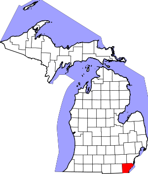 Map of Michigan highlighting Monroe County | |
| Villages | ||
| Charter townships | ||
| Civil townships | ||
| CDPs | ||
| Other unincorporated communities |
| |
| Ghost towns | ||
| Footnotes | ‡This populated place also has portions in an adjacent county or counties | |