Whiteface Mountain
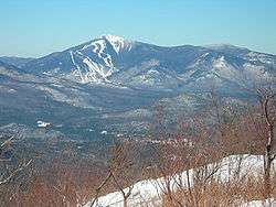
Whiteface Mountain is the fifth-highest mountain in the U.S. state of New York, and one of the High Peaks of the Adirondack Mountains. Set apart from most of the other High Peaks, the summit offers a 360-degree view of the Adirondacks and clear-day glimpses of Vermont and even Canada, where the skyscrapers of Montreal, 80 miles (130 km) away, can be seen on a very clear day. Located in the town of Wilmington, about 13 miles (21 km) from Lake Placid, the mountain's east slope is home to a major ski area which hosted the alpine skiing competitions of the 1980 Winter Olympics. Unique among the High Peaks, Whiteface features a developed summit and seasonal accessibility by motor vehicle. Whiteface Memorial Highway reaches a parking area at an elevation of 4,600 feet (1,400 m), with the remaining 267 feet (81 m) being obtained by tunnel and elevator.
| Whiteface Mountain | |
|---|---|
 Whiteface Mountain | |
| Highest point | |
| Elevation | 4,867 ft (1,483 m) |
| Prominence | 3,110 ft (950 m) |
| Listing | #5 Adirondack High Peaks |
| Coordinates | 44°21′57″N 73°54′10″W |
| Geography | |
 Whiteface Mountain Location of Whiteface, northeast of Lake Placid  Whiteface Mountain Whiteface Mountain (the United States) | |
| Location | Wilmington, New York, U.S. |
| Parent range | Adirondacks |
| Topo map | USGS Lake Placid |
| Climbing | |
| Easiest route | road |
Conceived and initiated prior to the Great Depression, Whiteface Castle and the Whiteface Mountain Veterans Memorial Highway were funded entirely by the state of New York, though the timing of the project led to a widespread belief that they were Depression-era public works projects arising from the New Deal.[1] Construction on the toll road began in 1929, after passage of a necessary amendment to the state constitution, with a groundbreaking ceremony featuring then-New York State Governor Franklin D. Roosevelt. Eventually costing 1.2 million dollars (18 million in 2018 dollars[2]) and ending vertically within 300 feet (90 m) of the summit the roadway is 5 miles (8 km) long and features an impressively steep 8% average grade. Officially opened July 20, 1935, in a ceremony featuring Roosevelt, by then President, the highway was dedicated to veterans of the Great War. The Highway is usually open to vehicles from May to October.
Whiteface Castle, built with granite excavated during the road construction, dominates the summit area. From the adjacent parking lot there are two routes to the summit proper. The first route is the Stairway Ridge Trail, a footpath with handrails and intermittent cement and stone steps approximately 0.2 miles (0.32 km) long. The second is a 424-foot (129 m) long tunnel into the core of the mountain. At the end of the tunnel is an elevator, which rises 276 feet (84 m), approximately 27 stories, to the summit.
Whiteface Mountain Ski Area
| Whiteface Mountain Ski Area | |
|---|---|
 | |
| Location | Wilmington, New York, U.S. |
| Nearest major city | Lake Placid - 13 miles (21 km) |
| Coordinates | 44°21′57″N 73°54′10″W |
| Vertical | 3,166 ft (965 m) (lift-served) 3,430 ft (1,045 m) |
| Top elevation | 4,386 ft (1,337 m) (lift-served) 4,650 ft (1,417 m) |
| Base elevation | 1,220 ft (372 m) |
| Skiable area | 314 acres (127 ha) |
| Runs | 87 total |
| Lift system | 1 gondola 9 chairlifts 1 conveyor lift |
| Terrain parks | 7 |
| Snowfall | 190 in (480 cm)[3] |
| Snowmaking | yes |
| Night skiing | no |
| Website | Whiteface.com |
Whiteface was part of the post-World War II growth in recreational skiing attributed to the efforts of returning veterans of the U.S. Army's 10th Mountain Division. It is a major ski area, run by the Olympic Regional Development Authority. Known for its big-mountain skiing, Whiteface is consistently ranked as one of the top ski resorts in the Northeast. It was a prime venue of the 1980 Winter Olympics, hosting all six of the alpine ski events.[4] Whiteface regularly hosts major alpine ski events, such as the US Alpine Skiing Championships, most recently in 2010, and is a U.S. Olympic Training Site.
Whiteface's highest lift unloads at 4,386 feet (1,337 m), a vertical drop of 3,166 ft (965 m) to the base area at 1,220 ft (372 m). Its hike-to terrain, The Slides, is 264 ft (80 m) higher at 4,650 ft (1,417 m), providing Whiteface with the greatest continuous vertical drop in eastern North America at 3,430 feet (1,045 m). Its neighbor, Little Whiteface, tops in elevation at 3,676 ft (1,120 m). Whiteface has a total of 22 miles (35 km) of ski terrain, spread out over 88 trails. 314 acres (127 ha) of skiing area includes 35 in-bounds, off-piste double-black diamond wilderness terrain skiing on "The Slides" (conditions permitting), 85.5 acres (34.6 ha) of tree skiing, 35 acres (14 ha) of expert extreme adventure terrain. The Slides is an unmaintained wilderness area that is rarely open due to safety hazards. They can only be accessed by hiking from the top of the Summit Quad. Whiteface has a separate area for beginners known as Bear Den Mountain (formerly Kids Kampus).
In recent years there have been major improvements in snowmaking and grooming. Whiteface contains 88 trails accessible by one gondola, nine chairlifts, and one conveyor lift. Some 98% of the trails are covered by snowmaking, excluding the glades and the Slides. The Slides are double-black diamond runs that are usually only open at the end of the skiing season due to avalanche danger. They are between 35 and 40 degrees with high natural hazards (such as waterfalls, rocks, cliffs, trees, and variable conditions) vertically for over 1,250 feet (381 m). The Slides are considered to be one of the most challenging ski slopes that are marked on a trail map in the Northeast.[5]
In summer, Whiteface Mountain offers gondola rides and mountain biking.
Climate
Whiteface Mountain has a subarctic climate (Dfc) according to the Köppen climate classification, with very cold, snowy winters and mild summers.
| Climate data for Whiteface Mountain, New York (1937-1946 normals, extremes 1937-1946) | |||||||||||||
|---|---|---|---|---|---|---|---|---|---|---|---|---|---|
| Month | Jan | Feb | Mar | Apr | May | Jun | Jul | Aug | Sep | Oct | Nov | Dec | Year |
| Record high °F (°C) | 42 (6) |
41 (5) |
63 (17) |
69 (21) |
73 (23) |
79 (26) |
78 (26) |
78 (26) |
75 (24) |
69 (21) |
57 (14) |
52 (11) |
79 (26) |
| Average high °F (°C) | 16.3 (−8.7) |
17.8 (−7.9) |
26.3 (−3.2) |
36.3 (2.4) |
50.9 (10.5) |
59.6 (15.3) |
62.7 (17.1) |
59.9 (15.5) |
53.9 (12.2) |
42.1 (5.6) |
30.9 (−0.6) |
20.0 (−6.7) |
39.7 (4.3) |
| Daily mean °F (°C) | 7.5 (−13.6) |
8.4 (−13.1) |
17.5 (−8.1) |
28.2 (−2.1) |
42.6 (5.9) |
51.4 (10.8) |
55.3 (12.9) |
53.1 (11.7) |
46.1 (7.8) |
33.6 (0.9) |
23.5 (−4.7) |
11.4 (−11.4) |
31.6 (−0.3) |
| Average low °F (°C) | −1.8 (−18.8) |
−1.1 (−18.4) |
8.7 (−12.9) |
20.1 (−6.6) |
34.2 (1.2) |
43.2 (6.2) |
47.9 (8.8) |
46.0 (7.8) |
38.3 (3.5) |
27.1 (−2.7) |
16.0 (−8.9) |
3.0 (−16.1) |
23.5 (−4.7) |
| Record low °F (°C) | −36 (−38) |
−35 (−37) |
−35 (−37) |
−18 (−28) |
9 (−13) |
16 (−9) |
28 (−2) |
28 (−2) |
16 (−9) |
6 (−14) |
−10 (−23) |
−34 (−37) |
−36 (−38) |
| Average precipitation inches (mm) | 4.11 (104) |
3.76 (96) |
3.27 (83) |
4.26 (108) |
3.84 (98) |
3.26 (83) |
4.20 (107) |
3.56 (90) |
4.48 (114) |
3.71 (94) |
4.08 (104) |
4.27 (108) |
46.80 (1,189) |
| Average snowfall inches (cm) | 27.0 (69) |
29.7 (75) |
19.2 (49) |
11.4 (29) |
1.1 (2.8) |
0.0 (0.0) |
0.0 (0.0) |
0.0 (0.0) |
0.2 (0.51) |
10.1 (26) |
23.2 (59) |
17.8 (45) |
139.7 (355.31) |
| Source: Western Regional Climate Center[6] | |||||||||||||
Gallery
 Whiteface Mountain
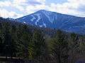 Whiteface Mountain from near Franklin Falls NY
.JPG) Whiteface Mountain as seen from Esther Mountain
Whiteface Mountain as seen from Esther Mountain View from the Cloudsplitter Gondola on the way to the summit of Little Whiteface
 A view of nearby Lake Placid from the summit of Whiteface Mountain
References
- Plattsburgh Press-Republican, September 14, 2010, Whiteface Memorial Highway feted at 75 (full text here)
- Thomas, Ryland; Williamson, Samuel H. (2019). "What Was the U.S. GDP Then?". MeasuringWorth. Retrieved April 6, 2019. United States Gross Domestic Product deflator figures follow the Measuring Worth series.
- Whiteface Stats - mountain stats
- 1980 Winter Olympics official report. Volume 1. pp. 20-8.
- "Best Ski Towns In America". Retrieved 15 September 2015.
- "WHITEFACE MOUNTAIN, NY". Western Regional Climate Center. Retrieved May 23, 2020.
External links
| Wikimedia Commons has media related to Whiteface Mountain. |
- Whiteface Mountain website
- Wilmington Historical Society Photos
- U.S. Geological Survey Geographic Names Information System: Whiteface Mountain
- Peakbagger.com: Whiteface Mountain
- Summitpost.org: Whiteface Mountain
- The History of Whiteface Mountain Ski Center
