Piz Nair
Piz Nair (3,056 metres (10,026 ft)) is a mountain of the Albula Alps in Switzerland, overlooking St. Moritz in the canton of Graubünden. The peak is easily accessible from the village with a funicular and a cable car; the upper station unloads 30 metres (100 ft) below the summit. Below the summit to the east is the Corviglia ski area.
| Piz Nair | |
|---|---|
 Piz Nair cable car station in 2006 | |
| Highest point | |
| Elevation | 3,056 m (10,026 ft) |
| Prominence | 183 m (600 ft) [1] |
| Parent peak | Piz Ot |
| Coordinates | 46°30′22.5″N 9°47′14.8″E |
| Geography | |
 Piz Nair Location in Switzerland | |
| Location | Graubünden, Switzerland |
| Parent range | Albula Alps |
| Climbing | |
| Easiest route | Cable car |

The mountain hosted the alpine skiing events for the 1948 Winter Olympics in neighboring St. Moritz.[2] It also hosted the World Championships in 1934, 1974, 2003 and 2017.
Gallery
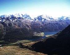 The Engadin Valley from the summit
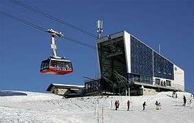 Corviglia intermediate station
See also
References
- Retrieved from the Swisstopo topographic maps. The key col is the Fuorcla Schlattain (2,873 m).
- 1948 Winter Olympics official report. pp. 6, 21. (in French and German)
External links
![]()

This article is issued from Wikipedia. The text is licensed under Creative Commons - Attribution - Sharealike. Additional terms may apply for the media files.