Weston, Nebraska
Weston is a village in Saunders County, Nebraska, United States. The population was 324 at the 2010 census.
Weston, Nebraska | |
|---|---|
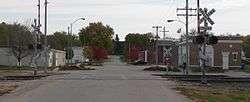 Downtown Weston | |
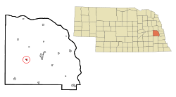 Location of Weston, Nebraska | |
| Coordinates: 41°11′34″N 96°44′32″W | |
| Country | United States |
| State | Nebraska |
| County | Saunders |
| Area | |
| • Total | 0.22 sq mi (0.58 km2) |
| • Land | 0.22 sq mi (0.58 km2) |
| • Water | 0.00 sq mi (0.00 km2) |
| Elevation | 1,250 ft (381 m) |
| Population | |
| • Total | 324 |
| • Estimate (2017)[3] | 327 |
| • Density | 1,466.37/sq mi (565.94/km2) |
| Time zone | UTC-6 (Central (CST)) |
| • Summer (DST) | UTC-5 (CDT) |
| ZIP code | 68070 |
| Area code(s) | 402 |
| FIPS code | 31-52540[4] |
| GNIS feature ID | 0834651[5] |
| Website | www |
History
Weston was platted in 1877 when the Omaha & Republican Valley Railroad was extended to that point.[6]
Geography
Weston is located at 41°11′34″N 96°44′32″W (41.192835, -96.742223).[7]
According to the United States Census Bureau, the village has a total area of 0.22 square miles (0.57 km2), all land.[8]
Demographics
| Historical population | |||
|---|---|---|---|
| Census | Pop. | %± | |
| 1880 | 53 | — | |
| 1890 | 341 | 543.4% | |
| 1900 | 426 | 24.9% | |
| 1910 | 432 | 1.4% | |
| 1920 | 372 | −13.9% | |
| 1930 | 365 | −1.9% | |
| 1940 | 371 | 1.6% | |
| 1950 | 345 | −7.0% | |
| 1960 | 340 | −1.4% | |
| 1970 | 285 | −16.2% | |
| 1980 | 286 | 0.4% | |
| 1990 | 299 | 4.5% | |
| 2000 | 310 | 3.7% | |
| 2010 | 324 | 4.5% | |
| Est. 2017 | 327 | [3] | 0.9% |
| U.S. Decennial Census[9] | |||
2010 census
At the 2010 census there were 324 people, 132 households, and 89 families living in the village. The population density was 1,472.7 inhabitants per square mile (568.6/km2). There were 152 housing units at an average density of 690.9 per square mile (266.8/km2). The racial makeup of the village was 96.0% White, 2.8% from other races, and 1.2% from two or more races. Hispanic or Latino of any race were 5.6%.[2]
Of the 132 households 30.3% had children under the age of 18 living with them, 52.3% were married couples living together, 9.1% had a female householder with no husband present, 6.1% had a male householder with no wife present, and 32.6% were non-families. 25.8% of households were one person and 17.4% were one person aged 65 or older. The average household size was 2.45 and the average family size was 2.99.
The median age in the village was 41.5 years. 26.5% of residents were under the age of 18; 6.7% were between the ages of 18 and 24; 20% were from 25 to 44; 29.3% were from 45 to 64; and 17.3% were 65 or older. The gender makeup of the village was 52.8% male and 47.2% female.
2000 census
At the 2000 census there were 310 people, 132 households, and 81 families living in the village. The population density was 1,006.1 people per square mile (386.1/km²). There were 138 housing units at an average density of 447.9 per square mile (171.9/km²). The racial makeup of the village was 100.00% White. Hispanic or Latino of any race were 0.32%.[4]
Of the 132 households 26.5% had children under the age of 18 living with them, 49.2% were married couples living together, 6.8% had a female householder with no husband present, and 38.6% were non-families. 33.3% of households were one person and 20.5% were one person aged 65 or older. The average household size was 2.33 and the average family size was 2.99.
The age distribution was 26.1% under the age of 18, 6.1% from 18 to 24, 27.1% from 25 to 44, 21.0% from 45 to 64, and 19.7% 65 or older. The median age was 40 years. For every 100 females, there were 93.8 males. For every 100 females age 18 and over, there were 95.7 males.
The median household income was $38,750, and the median family income was $44,583. Males had a median income of $32,500 versus $19,531 for females. The per capita income for the village was $17,076. About 5.1% of families and 8.8% of the population were below the poverty line, including 10.0% of those under age 18 and 11.1% of those age 65 or over.
Notable people
- Bob Cerv, baseball player
- Zach Miller, professional football player for the Chicago Bears
References
- "2017 U.S. Gazetteer Files". United States Census Bureau. Retrieved Jan 12, 2019.
- "U.S. Census website". United States Census Bureau. Retrieved 2012-06-24.
- "Population and Housing Unit Estimates". Retrieved March 24, 2018.
- "U.S. Census website". United States Census Bureau. Retrieved 2008-01-31.
- "US Board on Geographic Names". United States Geological Survey. 2007-10-25. Retrieved 2008-01-31.
- "Weston, Saunders County". Center for Advanced Land Management Information Technologies. University of Nebraska. Retrieved 23 August 2014.
- "US Gazetteer files: 2010, 2000, and 1990". United States Census Bureau. 2011-02-12. Retrieved 2011-04-23.
- "US Gazetteer files 2010". United States Census Bureau. Retrieved 2012-06-24.
- "Census of Population and Housing". Census.gov. Retrieved June 4, 2015.
External links
Municipalities and communities of Saunders County, Nebraska, United States | ||
|---|---|---|
| Cities | Map of Nebraska highlighting Saunders County | |
| Villages | ||
| Townships | ||
| CDP | ||
| Unincorporated communities | ||
Metropolitan area of Omaha–Council Bluffs | ||||||
|---|---|---|---|---|---|---|
| Primary cities |
|  | ||||
| Cities over 10,000 (per 2010 Census) |
| |||||
| Cities of 5,000 to 10,000 (per 2010 Census) |
| |||||
| Cities of 1,000 to 5,000 (per 2010 Census) |
| |||||
| Census-designated places |
| |||||
| Cities and villages of fewer than 1,000 (per 2010 Census) |
| |||||
| Counties |
| |||||