Mondamin, Iowa
Mondamin is a city in Harrison County, Iowa, United States. The population was 402 at the 2010 census.
Mondamin, Iowa | |
|---|---|
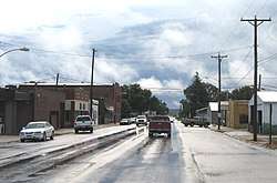 Downtown Mondamin, Iowa | |
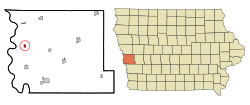 Location of Mondamin, Iowa | |
| Coordinates: 41°42′35″N 96°1′16″W | |
| Country | |
| State | |
| County | Harrison |
| Area | |
| • Total | 0.45 sq mi (1.17 km2) |
| • Land | 0.45 sq mi (1.17 km2) |
| • Water | 0 sq mi (0 km2) |
| Elevation | 1,024 ft (312 m) |
| Population | |
| • Total | 402 |
| • Estimate (2018)[3] | 377 |
| • Density | 893/sq mi (344.9/km2) |
| Time zone | UTC-6 (Central (CST)) |
| • Summer (DST) | UTC-5 (CDT) |
| ZIP code | 51557 |
| Area code(s) | 712 |
| FIPS code | 19-53175 |
| GNIS feature ID | 0459168 |
History
Mondamin was platted in the winter of 1867–1868 when the railroad was extended to that point.[4] It was named after Mondamin, a Native American corn deity.[5]
Geography
Mondamin is located at 41°42′35″N 96°1′16″W (41.709831, -96.021068).[6]
According to the United States Census Bureau, the city has a total area of 0.45 square miles (1.17 km2), all of it land.[1]
Demographics
| Historical populations | ||
|---|---|---|
| Year | Pop. | ±% |
| 1880 | 158 | — |
| 1890 | 257 | +62.7% |
| 1900 | 384 | +49.4% |
| 1910 | 420 | +9.4% |
| 1920 | 508 | +21.0% |
| 1930 | 534 | +5.1% |
| 1940 | 610 | +14.2% |
| 1950 | 489 | −19.8% |
| 1960 | 436 | −10.8% |
| 1970 | 420 | −3.7% |
| 1980 | 423 | +0.7% |
| 1990 | 403 | −4.7% |
| 2000 | 423 | +5.0% |
| 2010 | 402 | −5.0% |
| 2018 | 377 | −6.2% |
| Source:"U.S. Census website". United States Census Bureau. Retrieved 2020-03-29. and Iowa Data Center Source: | ||
2010 census
At the 2010 census there were 402 people, 175 households, and 122 families living in the city. The population density was 893.3 inhabitants per square mile (344.9/km2). There were 194 housing units at an average density of 431.1 per square mile (166.4/km2). The racial makeup of the city was 97.8% White, 0.2% African American, 0.5% Asian, 0.5% from other races, and 1.0% from two or more races. Hispanic or Latino of any race were 1.0%.[2]
Of the 175 households 29.1% had children under the age of 18 living with them, 50.9% were married couples living together, 10.3% had a female householder with no husband present, 8.6% had a male householder with no wife present, and 30.3% were non-families. 26.3% of households were one person and 15.5% were one person aged 65 or older. The average household size was 2.30 and the average family size was 2.70.
The median age was 44.8 years. 22.6% of residents were under the age of 18; 7.3% were between the ages of 18 and 24; 20.4% were from 25 to 44; 28.2% were from 45 to 64; and 21.6% were 65 or older. The gender makeup of the city was 50.0% male and 50.0% female.
2000 census
At the 2000 census there were 423 people, 175 households, and 120 families living in the city. The population density was 915.0 people per square mile (355.0/km²). There were 191 housing units at an average density of 413.1 per square mile (160.3/km²). The racial makeup of the city was 98.35% White, 0.24% Native American, and 1.42% from two or more races. Hispanic or Latino of any race were 0.24%.[8]
Of the 175 households 32.6% had children under the age of 18 living with them, 56.0% were married couples living together, 6.9% had a female householder with no husband present, and 30.9% were non-families. 26.3% of households were one person and 12.6% were one person aged 65 or older. The average household size was 2.42 and the average family size was 2.92.
The age distribution was 26.2% under the age of 18, 6.1% from 18 to 24, 29.1% from 25 to 44, 22.0% from 45 to 64, and 16.5% 65 or older. The median age was 37 years. For every 100 females, there were 93.2 males. For every 100 females age 18 and over, there were 90.2 males.
The median household income was $40,278 and the median family income was $41,406. Males had a median income of $31,667 versus $21,146 for females. The per capita income for the city was $18,123. About 4.9% of families and 3.1% of the population were below the poverty line, including 1.6% of those under age 18 and 3.0% of those age 65 or over.
Education
It is within the West Harrison Community School District.[9]
References
- "US Gazetteer files 2010". United States Census Bureau. Archived from the original on 2012-01-25. Retrieved 2012-05-11.
- "U.S. Census website". United States Census Bureau. Retrieved 2012-05-11.
- "Population and Housing Unit Estimates". Retrieved March 28, 2020.
- History of Western Iowa, Its Settlement and Growth. Western Publishing Company. 1882. pp. 290.
- Chicago and North Western Railway Company (1908). A History of the Origin of the Place Names Connected with the Chicago & North Western and Chicago, St. Paul, Minneapolis & Omaha Railways. p. 104.
- "US Gazetteer files: 2010, 2000, and 1990". United States Census Bureau. 2011-02-12. Retrieved 2011-04-23.
- "Census of Population and Housing". Census.gov. Retrieved June 4, 2015.
- "U.S. Census website". United States Census Bureau. Retrieved 2008-01-31.
- "West Harrison." Iowa Department of Education. Retrieved on July 16, 2018.
Metropolitan area of Omaha–Council Bluffs | ||||||
|---|---|---|---|---|---|---|
| Primary cities |
|  | ||||
| Cities over 10,000 (per 2010 Census) |
| |||||
| Cities of 5,000 to 10,000 (per 2010 Census) |
| |||||
| Cities of 1,000 to 5,000 (per 2010 Census) |
| |||||
| Census-designated places |
| |||||
| Cities and villages of fewer than 1,000 (per 2010 Census) |
| |||||
| Counties |
| |||||
Municipalities and communities of Harrison County, Iowa, United States | ||
|---|---|---|
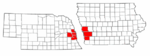
| Cities | Map of Iowa highlighting Harrison County | |
| Townships | ||
| CDPs | ||
| Other unincorporated communities | ||
| Footnotes | ‡This populated place also has portions in an adjacent county or counties | |