McClelland, Iowa
McClelland is a city in Pottawattamie County, Iowa, United States. The population was 151 at the 2010 census.
McClelland, Iowa | |
|---|---|
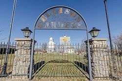 Ellison Gardens in McClelland, Iowa | |
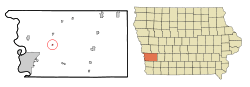 Location of McClelland, Iowa | |
| Coordinates: 41°19′45″N 95°41′3″W | |
| Country | |
| State | |
| County | Pottawattamie |
| Area | |
| • Total | 0.17 sq mi (0.44 km2) |
| • Land | 0.17 sq mi (0.44 km2) |
| • Water | 0 sq mi (0 km2) |
| Elevation | 1,243 ft (379 m) |
| Population | |
| • Total | 151 |
| • Estimate (2016)[3] | 150 |
| • Density | 888/sq mi (342.9/km2) |
| Time zone | UTC-6 (Central (CST)) |
| • Summer (DST) | UTC-5 (CDT) |
| ZIP code | 51548 |
| Area code(s) | 712 |
| FIPS code | 19-47865 |
| GNIS feature ID | 0458890 |
Geography
McClelland is located at 41°19′45″N 95°41′03″W (41.329145, -95.684056).[4]
According to the United States Census Bureau, the city has a total area of 0.17 square miles (0.44 km2), all land.[1]
Demographics
| Historical populations | ||
|---|---|---|
| Year | Pop. | ±% |
| 1910 | 134 | — |
| 1920 | 142 | +6.0% |
| 1930 | 161 | +13.4% |
| 1940 | 165 | +2.5% |
| 1950 | 159 | −3.6% |
| 1960 | 150 | −5.7% |
| 1970 | 146 | −2.7% |
| 1980 | 177 | +21.2% |
| 1990 | 139 | −21.5% |
| 2000 | 129 | −7.2% |
| 2010 | 151 | +17.1% |
| 2016 | 150 | −0.7% |
| Source:"U.S. Census website". United States Census Bureau. Retrieved 2020-03-29. and Iowa Data Center Source: | ||
2010 census
At the 2010 census there were 151 people, 54 households, and 45 families living in the city. The population density was 888.2 inhabitants per square mile (342.9/km2). There were 56 housing units at an average density of 329.4 per square mile (127.2/km2). The racial makeup of the city was 94.0% White, 1.3% African American, 0.7% from other races, and 4.0% from two or more races. Hispanic or Latino of any race were 2.0%.[2]
Of the 54 households 38.9% had children under the age of 18 living with them, 70.4% were married couples living together, 9.3% had a female householder with no husband present, 3.7% had a male householder with no wife present, and 16.7% were non-families. 13.0% of households were one person and 3.7% were one person aged 65 or older. The average household size was 2.80 and the average family size was 3.02.
The median age was 36.5 years. 28.5% of residents were under the age of 18; 7.9% were between the ages of 18 and 24; 28.4% were from 25 to 44; 28.5% were from 45 to 64; and 6.6% were 65 or older. The gender makeup of the city was 45.7% male and 54.3% female.
2000 census
At the 2000 census there were 129 people, 50 households, and 35 families living in the city. The population density was 803.7 people per square mile (311.3/km2). There were 51 housing units at an average density of 317.7 per square mile (123.1/km2). The racial makeup of the city was 97.67% White, and 2.33% from two or more races. Hispanic or Latino of any race were 0.78%.[6]
Of the 50 households 34.0% had children under the age of 18 living with them, 56.0% were married couples living together, 6.0% had a female householder with no husband present, and 30.0% were non-families. 18.0% of households were one person and none had someone living alone who was 65 or older. The average household size was 2.58 and the average family size was 2.89.
The age distribution was 26.4% under the age of 18, 5.4% from 18 to 24, 35.7% from 25 to 44, 24.0% from 45 to 64, and 8.5% 65 or older. The median age was 38 years. For every 100 females, there were 101.6 males. For every 100 females age 18 and over, there were 115.9 males.
The median household income was $41,625 and the median family income was $41,875. Males had a median income of $29,531 versus $28,438 for females. The per capita income for the city was $22,155. There were no families and 2.3% of the population living below the poverty line, including no under eighteens and none of those over 64.
Education
The Underwood Community School District serves McClelland.[7]
References
- "US Gazetteer files 2010". United States Census Bureau. Archived from the original on January 12, 2012. Retrieved 2012-05-11.
- "U.S. Census website". United States Census Bureau. Retrieved 2012-05-11.
- "Population and Housing Unit Estimates". Retrieved June 9, 2017.
- "US Gazetteer files: 2010, 2000, and 1990". United States Census Bureau. 2011-02-12. Retrieved 2011-04-23.
- "Census of Population and Housing". Census.gov. Retrieved June 4, 2015.
- "U.S. Census website". United States Census Bureau. Retrieved 2008-01-31.
- "Underwood" (PDF). Iowa Department of Education. Retrieved 2020-03-27.
Metropolitan area of Omaha–Council Bluffs | ||||||
|---|---|---|---|---|---|---|
| Primary cities |
|  | ||||
| Cities over 10,000 (per 2010 Census) |
| |||||
| Cities of 5,000 to 10,000 (per 2010 Census) |
| |||||
| Cities of 1,000 to 5,000 (per 2010 Census) |
| |||||
| Census-designated places |
| |||||
| Cities and villages of fewer than 1,000 (per 2010 Census) |
| |||||
| Counties |
| |||||
Municipalities and communities of Pottawattamie County, Iowa, United States | ||
|---|---|---|
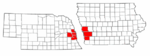
| Cities | Map of Iowa highlighting Pottawattamie County | |
| Townships | ||
| CDPs | ||
| Other community | ||
| Footnotes | ‡This populated place also has portions in an adjacent county or counties | |