West Township, Columbiana County, Ohio
West Township is one of the eighteen townships of Columbiana County, Ohio, United States. The 2010 census reported 3,307 people living in the township,[3] 3,305 of whom were in the unincorporated portions of the township.[4]
West Township, Columbiana County, Ohio | |
|---|---|
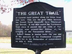 The Great Trail passed through this area | |
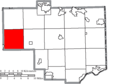 Location of West Township in Columbiana County | |
| Coordinates: 40°46′11″N 81°2′13″W | |
| Country | United States |
| State | Ohio |
| County | Columbiana |
| Area | |
| • Total | 35.1 sq mi (90.9 km2) |
| • Land | 34.9 sq mi (90.4 km2) |
| • Water | 0.2 sq mi (0.5 km2) |
| Elevation | 1,112 ft (339 m) |
| Population (2010) | |
| • Total | 3,307 |
| • Density | 95/sq mi (36.6/km2) |
| Time zone | UTC-5 (Eastern (EST)) |
| • Summer (DST) | UTC-4 (EDT) |
| FIPS code | 39-82852[2] |
| GNIS feature ID | 1085907[1] |
Geography
Located in the western part of the county, it borders the following townships:
- Knox Township - north
- Butler Township - northeast corner
- Hanover Township - east
- East Township, Carroll County - southeast
- Augusta Township, Carroll County - south
- Brown Township, Carroll County - southwest corner
- Paris Township, Stark County - west
- Washington Township, Stark County - northwest corner
One village and one unincorporated community are located in West Township:
- The village of Minerva, in the southwest
- The unincorporated community of East Rochester, in the south
Name and history
| Historical population | |||
|---|---|---|---|
| Census | Pop. | %± | |
| 1980 | 3,022 | — | |
| 1990 | 3,162 | 4.6% | |
| 2000 | 3,351 | 6.0% | |
| 2010 | 3,307 | −1.3% | |
| Est. 2018 | 3,125 | [5] | −5.5% |
| U.S. Decennial Census[6] | |||
It is the only West Township statewide.[7]
The township was organized in 1814.[8]
Government
The township is governed by a three-member board of trustees, who are elected in November of odd-numbered years to a four-year term beginning on the following January 1. Two are elected in the year after the presidential election and one is elected in the year before it. There is also an elected township fiscal officer,[9] who serves a four-year term beginning on April 1 of the year after the election, which is held in November of the year before the presidential election. Vacancies in the fiscal officership or on the board of trustees are filled by the remaining trustees.
Township Trustees
Fiscal Officer
- Jeff Haynam[10]
References
- "US Board on Geographic Names". United States Geological Survey. 2007-10-25. Retrieved 2008-01-31.
- "U.S. Census website". United States Census Bureau. Retrieved 2008-01-31.
- "Geographic Identifiers: 2010 Demographic Profile Data (G001): West township, Columbiana County, Ohio". U.S. Census Bureau, American Factfinder. Archived from the original on January 28, 2015. Retrieved January 28, 2015.
- "Geographic Identifiers: 2010 Demographic Profile Data (G001): Minverva village (part), West township, Columbiana County, Ohio". U.S. Census Bureau, American Factfinder. Archived from the original on January 28, 2015. Retrieved January 28, 2015.
- "Population and Housing Unit Estimates". Retrieved June 12, 2019.
- "Census of Population and Housing" (PDF). Census.gov. Retrieved July 17, 2018.
- "Detailed map of Ohio" (PDF). United States Census Bureau. 2000. Retrieved 2007-02-16.
- Cranmer, Gibson Lamb (1891). History of the upper Ohio Valley. 2. Madison, Wisconsin: Brant & Fuller. p. 22.
- §503.24, §505.01, and §507.01 of the Ohio Revised Code. Accessed 4/30/2009.
- "Columbiana County Elected Officials as of Jan. 1, 2020" (PDF). Retrieved January 19, 2020.
External links
Municipalities and communities of Columbiana County, Ohio, United States | ||
|---|---|---|
| Cities | 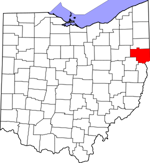 Map of Ohio highlighting Columbiana County | |
| Villages | ||
| Townships | ||
| CDPs | ||
| Unincorporated communities |
| |
| Ghost town | ||
| Footnotes | ‡This populated place also has portions in an adjacent county or counties | |