East Liverpool, Ohio
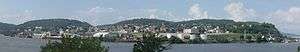
East Liverpool is a city in Columbiana County, Ohio, United States. The population was 11,195 at the time of the 2010 census. It is located along the Ohio River and borders the states of Pennsylvania and West Virginia. East Liverpool is included in the Salem, OH Micropolitan Statistical Area, approximately 40 miles (64 km) from both Youngstown as well as downtown Pittsburgh.
East Liverpool, Ohio | |
|---|---|
City | |
| City of East Liverpool | |
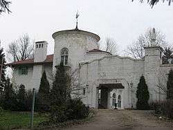
 East Fifth Street Historic District | |
| Nickname(s): Pottery Capital of the World, Crockery City, City of Action | |
| Motto(s): "We're Open for Business" | |
 Location of East Liverpool in Columbiana County and in the State of Ohio | |
| Coordinates: 40°37′43″N 80°34′9″W | |
| Country | United States |
| State | Ohio |
| County | Columbiana |
| Government | |
| • Type | Mayor-Council |
| • Mayor | Gregory T. Bricker (R)[1] |
| • Council President | John A. Torma (D)[1] |
| Area | |
| • Total | 4.76 sq mi (12.33 km2) |
| • Land | 4.56 sq mi (11.81 km2) |
| • Water | 0.20 sq mi (0.52 km2) |
| Elevation | 768 ft (234 m) |
| Population | |
| • Total | 11,195 |
| • Estimate (2019[5]) | 10,603 |
| • Density | 2,455.0/sq mi (947.9/km2) |
| Time zone | UTC−5 (Eastern (EST)) |
| • Summer (DST) | UTC−4 (EDT) |
| ZIP code | 43920 |
| Area code | 330, 234 |
| FIPS code | 39-23730[6] |
| GNIS feature ID | 1061038[3] |
| School District | East Liverpool City |
| Website | http://www.eastliverpool.com/ |
Historically, it was the "Pottery Capital" of the United States due to the large number of potteries in the city; however, due to changes in the ceramics industry, only three remain in the area.[7][8] The city is also known as the hometown of former NCAA Division I football coach Lou Holtz. The Beginning Point of the U.S. Public Land Survey is just east of the city center, on the Ohio–Pennsylvania border. Because of its role in the ceramics industry, the town is one of the settings in author Holly Black's award-winning middle-grade novel, Doll Bones.
History

East Liverpool traces its American settlement to 1798 when Thomas Fawcett purchased 1,100 acres of land along the Ohio River in what was then Jefferson County. In 1802 he platted the town of St. Clair, named for Arthur St. Clair, who at that time was Governor of the Northwest Territory.[9] It was called Fawcettstown for a time by the residents. In 1816, they changed the name to Liverpool. It was incorporated as East Liverpool in 1834 when Liverpool Township in Medina County objected to possible confusion.
Pottery industry
The local potteries became the national center of ceramic toilet and table wares, with 85 firms operating at one time or another making two=thirds of the national output 1880 to 1950. The East Liverpool pottery district encompasses East Liverpool and the towns of Wellsville, Ohio, and Chester and Newell, West Virginia, directly across the Ohio River. In 1887 East Liverpool boasted 21 general ware potteries which employed 2,558 operatives. By 1923 the 17 firms had 7,000 employees and operated 270 kilns, with $25,000,000 in annual output.[10]
Englishman James Bennett established the industry in 1839, making use of good transportation and rich local clays. It quickly became the community's leading industry. East Liverpool became known as "The Crockery City." Potters from Staffordshire, England began pouring into East Liverpool. They were attracted mostly by higher wages, but also by the prospect of land ownership. By 1879, there were 24 potteries in East Liverpool, nearly all of whom were operated by English immigrants. As late as 1900, East Liverpool remained "essentially a transplanted potting town of Englishmen".[11] Up until the turn of the century probably 85% percent of the population could trace its heritage to English background.[12] After the English, the second largest ethnic group in East Liverpool were German settlers.[13] From 1870 through 1890, the US Census showed that the city more than doubled in population each decade, as it attracted new industrial workers with the growth of the pottery industry. By 1910, it had more than 20,000 people. East Liverpool once produced more than half of the United States's annual ceramics output. Throughout East Liverpool's ceramics history, there were more than 300 potteries.
Of these potteries, three continue to operate in the area: the American Mug & Stein Company, the Hall China Company, and the Homer Laughlin China Company. In the mid-19th century, East Liverpool also produced most of the yellowware pottery used in the United States. Among the most famous of East Liverpool's ceramics was the porcelain known as Lotus Ware. Produced by Knowles, Taylor & Knowles in the 1890s, this Moorish- and Persian-influenced artware swept the competition at the 1893 World's Fair in Chicago. It is generally considered to be the finest porcelain ever produced in the US. The Museum of Ceramics in downtown East Liverpool has the world's largest public display of Lotus Ware.
As of 1914, East Liverpool was served by the Cleveland and Pittsburgh Railroad.[14]
The city reached its peak population of more than 26,000 in 1970, but East Liverpool's pottery industry had already begun its decline by the mid-1960s or so. As with other industries, production moved to developing countries where labor costs were cheaper. This cost many jobs and, ultimately, population in the Ohio/West Virginia area, as people moved away in search of work.
In the mid-1990s, the city renovated its downtown district. To improve its urban design, it installed Great Depression-era lightposts, developed a new center called Devon's Diamond, and reconstructed the old high school's clocktower. This building is now the home of the East Liverpool High School Alumni Association.
National Register of Historic Places listings
Due to being the home of a large industry with many wealthy business owners, there are today 16 different properties and 3 districts are listed on the National Register of Historic Places, in addition to the Beginning Point of the U.S. Public Land Survey, the only National Historic Landmark in Columbiana County.[15]
Historic Districts
The Diamond Historic District is located at the one sided traffic diamond between Market Street and East Sixth Street. The area is triangular, bounded by three roads. Buildings at the Diamond date back to 1884.[16] The East Fifth Street Historic District consists of three blocks of downtown East Liverpool along East Fifth street between Market Street and Broadway, listed due to its examples of Neoclassical architecture.[17] East Liverpool Downtown Historic District covers the whole of downtown in 22 acres, and is noted for its Italianate and Second Empire architecture as well as its prominence as a commercial center in East Liverpool's history.[17]
Historic Structures
Many of the historic properties in East Liverpool were the homesteads of prominent business owners throughout the late 19th century. These include the Cassius Clark Thompson House (1876), Ikirt House (1888), Homer Laughlin House (1882), Godwin-Knowles House (1890), and the Richard L. Cawood Residence (1923), all of unique architectural styles.[15]
The remaining structures on the listing are examples of large, multi-story businesses that had historical significance in East Liverpool's economy and community during the 20th century. Listings include the original East Liverpool Post Office (1909), East Liverpool Pottery (1844), Andrew Carnegie's Public Library (1902), the original YMCA (1913), the Civil Works Administration's City Hall (1934), the Elks Club building (1916), Odd Fellows Temple (1907), Mary A. Patterson Memorial building (1924), Potters Savings and Loan (1904), the first Potters National Bank (1881), and the Travelers Hotel (1907).[15]
Areas and neighborhoods
- Downtown – East Liverpool's centralized business district, located on the "flats" in the river valley. Downtown is considered to lie between U.S. Route 30 in the west, College and Walnut streets in the east, West 2nd Street in the South, and Moore and Grant streets in the North. The heart of the business center during the first half of the nineteenth century was located between the Ohio River and 3rd Street. However, during the second half of the century, as East Liverpool attracted more industry and the population grew, the center of business moved north between 4th and 6th Streets. Business remained near the river until the regional economic depression beginning in the 1960s. a freeway was constructed between the river and downtown, leading to demolition of much of the original business center between 2nd and 3rd Streets. Only a few residents, a few small industries, and the Broadway Wharf remain near 2nd Street and the river, both now geographically separated from Downtown by the highway.
- West End – The western end of the city is located between the Ohio State Routes 7/11/39/U.S. Route 30 freeway in the east, Shadyside Road in the west, Riverside Park in the south and Hazel Street in the north. Until the freeway project in the 1960s and '70s, the West End was "connected" to Downtown. However, like the riverfront area of Downtown, it is now geographically isolated on the other side of the freeway. It is home to Westgate Middle School and Patterson Field, the city's football stadium. The West End has two distinct small neighborhoods:
- Sunnyside – Between Lisbon and West 9th streets to the south and Hazel Street in the north.
- Jethro – South of West 8th Street, between Gaston Avenue in the east and Edwards Street in the west. Before the rapid growth of the city in the second half of the nineteenth century, Jethro was a separate village. It was later incorporated into the city. Residents used to live in the low-lying area to its west known as Jethro Hollow, but most have since moved out due to flood risks from the river.

- East End – The East End is within the city limits, but it is almost entirely isolated from the rest of East Liverpool, connected only by River Road and the Route 11/39 freeway. East End is considered to be all of the flats between St. George and State streets in the west and the border with Pennsylvania in the east. Similar to Jethro in the West End, East End originated as a few separate satellite communities that were absorbed in the nineteenth century by the growing city .
- Pleasant Heights – A neighborhood situated on top of a plateau above the West End to the south and the freeway to the east, Pleasant Heights surrounds Lisbon Street (Ohio State Route 267). Its southernmost point is the dead end of Oakwood Street, and it extends north to Myler Road. Pleasant Heights was one of the several neighborhoods developed during East Liverpool's expansion "up the hill" in the late nineteenth and early twentieth centuries.
- Fisher Park – A self-contained neighborhood, all between South and North Shadylane drives on the east side of Lisbon Street. Named for the Fisher Farm located in the area, the farm house can still be found along Lisbon Street as a private residence.
- Beechwood – The neighborhood situated above Maine Boulevard between Anderson Boulevard and Park Way.
- Thompson – This neighborhood borders the east end of Downtown. It extends east from College and Walnut streets and goes "up the hill" above the freeway. Its northern end is Morton and Bank streets, and extends to the edge of the hill at Thompson Avenue and Vine Street.
Satellite communities
Though not located within the city limits, there are a few communities that share East Liverpool's 43920 ZIP code and have an East Liverpool mailing address, including the census-designated places of Calcutta, Glenmoor and La Croft, and the unincorporated community of Fredericktown.
Neighboring communities
In the bordering states of West Virginia and Pennsylvania, the communities of Chester and Newell, West Virginia and Glasgow, Pennsylvania developed and grew in relation to the growth of the pottery industry and expansion of East Liverpool in the late nineteenth and early twentieth centuries.
In its most liberal definition, the East Liverpool area extends as far north as Negley, as far west as Salineville, as far east as Midland, Pennsylvania, and as far south as New Cumberland, West Virginia. The United States Census Bureau defines communities in this region as being parts of the Salem, OH Micropolitan Statistical Area, Weirton-Steubenville, WV-OH Metropolitan Statistical Area, or Pittsburgh, PA Metropolitan Statistical Area, although the area as a whole is considered part of the Greater Pittsburgh Region.
Education
Primary and secondary
Children in East Liverpool (and immediate surrounding areas in Liverpool Township) are served by the East Liverpool City School District. The current schools in the district are:
- La Croft Elementary School – 2460 Boring Lane (located immediately outside the city limits in La Croft), grades K-4
- North Elementary School – 100 Maine Boulevard, grades K-4
- Westgate Middle School – 810 West 8th Street, grades 5-6
- East Liverpool Junior/Senior High School – 100 Maine Boulevard, grades 7-12
The East Liverpool Christian School also serves grades K-12 as the primary area private school option. In addition, an online school, Buckeye Online School for Success, operates out of downtown.
St. Aloysius School (K-8) formerly operated for 130 years as a Roman Catholic School in the Diocese of Youngstown, before closing on June 6, 2015.
Postsecondary
Kent State University has been operating a satellite campus, Kent State University at East Liverpool, since 1965. It is clustered around 4th Street in Downtown. The Ohio Valley College of Technology in nearby Calcutta also focuses on job training.
Transportation
Highways
The following highways pass through East Liverpool:
Airports
The Columbiana County Airport is located four miles northwest of the city.
Bridges
Since the 1890s, East Liverpool and the West Virginia communities of Chester and Newell have been connected by three different bridges spanning the Ohio River.
- Chester Bridge (1896–1969) – Connected College Street in East Liverpool with 1st Street in Chester. It was the original bridge to carry U.S. Route 30. The bridge closed on May 14, 1969, and was demolished in 1970.[18]
- Newell Bridge (1905–present) – Connects West 5th Street near East Liverpool City Hospital with West Virginia State Route 2. It is the only privately owned toll bridge on the Ohio River, owned and operated by the Homer Laughlin China Company out of Newell.[19]
- Jennings Randolph Bridge (1977–present) – Replaced the demolished Chester Bridge in the 1970s as the span connecting East Liverpool and Chester, and carrying Route 30 over the river. Named for West Virginia congressman/senator Jennings Randolph (in office 1933-1947 and 1958–1985, respectively).[19]
Recreation
Golf courses
The East Liverpool Country Club has a 9-hole golf course that was designed by Willie Park, Jr. and opened on July 14, 1921. Courses in the 43920 vicinity include the 18-hole Turkana Golf Course in Calcutta, the 9-hole Highland Country Club in Glenmoor and the 18-hole Beaver Creek Meadows Golf Course in Williamsport.
Parks
There are two public parks located within East Liverpool city limits.
- Thompson Park – After Will Lamartine Thompson donated 100 acres of land to the city of East Liverpool in 1899,[20] Thompson Park opened in 1900 as a green space to get away from the industry of the city.[19] It has been open ever since, and amenities include picnic pavilions, a swimming pool, a football field, a baseball field, a disc golf course, a playground and walking trails. The main entrance to Thompson Park is located on Park Way at the end of Park Boulevard. There is also a back entrance on Anderson Boulevard.
- Broadway Wharf – A small public park/boat launch near the Ohio River. Located near the ends of Broadway, East 2nd Street and River Road.
Additionally, Beaver Creek State Park is located outside the city limits but partially within the 43920 ZIP code area.
Athletics
Because of its size, East Liverpool has never had a major professional sports team. However, during the city's heyday, many semipro and company teams, and city and area leagues were thriving. Baseball, basketball and American football were all popular among residents, and games attracted many patrons. The semipro East Liverpool Potters basketball team of the Central Basketball League played in the city from 1906 to 1909. No semipro or company teams exist in the city today.
East Liverpool High School athletics have been consistently popular among students and residents in the past 100-plus years. All of the teams are known as the Potters. The school fields American football, baseball, basketball, bowling, cross country running, golf, soccer, softball, swimming, tennis, track and field, volleyball and wrestling teams. Most of these teams have had team and/or individual successes in their existences. Athletic facilities include:
- Patterson Field – football stadium, opened 1924 (current concrete bleachers constructed in 1934). Located near East Liverpool Middle School at 810 West 8th Street.
- Potter Fieldhouse – home of Potters basketball, volleyball and wrestling. Located next to East Liverpool High School at 100 Maine Boulevard.
- ELHS Baseball Field – located between the high school and Trinity Presbyterian Church on Maine Boulevard.
Media
Newspapers
East Liverpool was once home to several newspapers, but only The Review survives, serving chiefly southern Columbiana County and northern Hancock County. Additionally, the Morning Journal reports in the area.
Radio
The radio station WOHI 1490 AM has broadcast from the city since December 1, 1949. The city also had a station on the FM dial 104.3, WOGI, but its city of license was moved to Moon Township, Pennsylvania and now serves the Pittsburgh radio market. The following radio stations can be received in East Liverpool:
AM Radio
FM Radio
- WQED 89.3 FM, Classical
- WVNP 89.9 FM, Public
- WKPL 92.1 FM, Classic Hits
- WDJQ 92.5 FM, Top-40
- WLTJ 92.9 FM, Hot Adult Contemporary
- WNCD 93.3 FM, Rock
- KDKA 93.7 FM, Sports
- WWSW 94.5 FM, Classic Hits
- WYLE 95.1 FM, Classic Country
- WKST 96.1 FM, Top-40
- WRRK 96.9 FM, Adult Hits
- WMXY 98.9 FM, Adult Contemporary
- WSHH 99.7 FM, Adult Contemporary
- WHOT 101.1 FM, Top-40
- WORD 101.5 FM, Religious
- WDVE 102.5 FM, Rock
- WYFM 102.9 FM, Classic Rock
- WLYI 103.5 FM, Classic Country
- WOGI 104.3 FM, Country
- WPGB 104.7 FM, Country
- WQXK 105.1 FM, Country
- WXDX 105.9 FM, Alternative
- WAOB 106.7 FM, Religious
- WDSY 107.9 FM, Country
Television
Though East Liverpool has never had a local television station of its own, the area receives the following stations from Pittsburgh, Youngstown and Steubenville.
Geography
East Liverpool is located at 40°37′43″N 80°34′9″W (40.628510, -80.569063).[21] It lies within the ecoregion of the Western Allegheny Plateau.[22]
According to the United States Census Bureau, the city has a total area of 4.76 square miles (12.33 km2), of which 4.56 square miles (11.81 km2) is land and 0.20 square miles (0.52 km2) is water.[2]
Demographics
| Historical population | |||
|---|---|---|---|
| Census | Pop. | %± | |
| 1830 | 136 | — | |
| 1840 | 503 | 269.9% | |
| 1850 | 987 | 96.2% | |
| 1860 | 1,308 | 32.5% | |
| 1870 | 2,105 | 60.9% | |
| 1880 | 5,568 | 164.5% | |
| 1890 | 10,956 | 96.8% | |
| 1900 | 16,485 | 50.5% | |
| 1910 | 20,387 | 23.7% | |
| 1920 | 21,411 | 5.0% | |
| 1930 | 23,329 | 9.0% | |
| 1940 | 23,555 | 1.0% | |
| 1950 | 24,217 | 2.8% | |
| 1960 | 22,306 | −7.9% | |
| 1970 | 26,243 | 17.6% | |
| 1980 | 16,517 | −37.1% | |
| 1990 | 13,654 | −17.3% | |
| 2000 | 13,089 | −4.1% | |
| 2010 | 11,195 | −14.5% | |
| Est. 2019 | 10,817 | [5] | −3.4% |
| Sources:[6][23][24][25] | |||
2010 census
As of the census[4] of 2010, there were 11,195 people, 4,601 households, and 2,892 families residing in the city. The population density was 2,455.0 inhabitants per square mile (947.9/km2). There were 5,316 housing units at an average density of 1,165.8 per square mile (450.1/km2). The racial makeup of the city was 91.7% White, 4.6% African American, 0.2% Native American, 0.2% Asian, 0.3% from other races, and 3.0% from two or more races. Hispanic or Latino of any race were 1.1% of the population.
There were 4,601 households, of which 33.4% had children under the age of 18 living with them, 36.0% were married couples living together, 20.1% had a female householder with no husband present, 6.7% had a male householder with no wife present, and 37.1% were non-families. 31.9% of all households were made up of individuals, and 11.9% had someone living alone who was 65 years of age or older. The average household size was 2.39 and the average family size was 2.97.
The median age in the city was 37.6 years. 25.4% of residents were under the age of 18; 9.5% were between the ages of 18 and 24; 24% were from 25 to 44; 26.5% were from 45 to 64; and 14.6% were 65 years of age or older. The gender makeup of the city was 47.6% male and 52.4% female.
2000 census
As of the census[6] of 2000, there were 13,089 people, 5,261 households, and 3,424 families residing in the city. The population density was 3,010.3 people per square mile (1,161.8/km2). There were 5,743 housing units at an average density of 1,320.8 per square mile (509.7/km2). The racial makeup of the city was 92.85% White, 4.81% African American, 0.24% Native American, 0.08% Asian, 0.05% Pacific Islander, 0.21% from other races, and 1.76% from two or more races. Hispanic or Latino of any race were 0.72% of the population.
There were 5,261 households, out of which 32.9% had children under the age of 18 living with them, 43.5% were married couples living together, 16.6% had a female householder with no husband present, and 34.9% were non-families. 30.3% of all households were made up of individuals, and 13.5% had someone living alone who was 65 years of age or older. The average household size was 2.44 and the average family size was 3.01.
In the city the population was spread out, with 27.1% under the age of 18, 8.8% from 18 to 24, 27.3% from 25 to 44, 20.8% from 45 to 64, and 16.0% who were 65 years of age or older. The median age was 36 years. For every 100 females, there were 86.5 males. For every 100 females age 18 and over, there were 81.8 males.
The median income for a household in the city was $23,138, and the median income for a family was $27,500. Males had a median income of $27,346 versus $18,990 for females. The per capita income for the city was $12,656. About 21.5% of families and 25.2% of the population were below the poverty line, including 35.2% of those under age 18 and 13.0% of those age 65 or over.
Notable people
- Dan Adkins – comic book artist for Marvel Comics
- Bernie Allen – former Major League Baseball second baseman
- Dick Booth – former National Football League halfback
- Less Browne – former United States Football League and Canadian Football League defensive back
- John Caparulo – stand-up comedian
- Jane Louise Curry – children's novel author
- Ben Feldman – prolific life insurance salesman
- Benedict Charles Franzetta – former Catholic bishop
- John Godwin – former Major League Baseball player
- Lou Holtz – author, television commentator, motivational speaker, and former NCAA football coach
- George P. Ikirt – physician and U.S. Representative from Ohio
- Bob McFadden – voice actor
- O. O. McIntyre – columnist of New York Day by Day
- Hy Myers – former Major League Baseball player, led the National League in RBIs and slugging percentage in 1919 while playing for the Brooklyn Dodgers
- Elaine Riley – actress with Paramount Pictures
- Ruth Crawford Seeger – composer and first woman to receive the Guggenheim Fellowship
- Josh Stansbury – Mixed martial artist, current UFC light heavyweight division fighter
- Josiah Thompson – author of Six Seconds in Dallas
- Will Lamartine Thompson – composer of hymns and gospel music
- Norm Van Lier – former National Basketball Association point guard
- Jabez Vodrey – prominent early potter
- Peter Wooley – former Hollywood film producer and Emmy Award nominated art director
References
- "Columbiana County Elected Officials as of Jan. 1, 2020" (PDF). Retrieved January 19, 2020.
- "US Gazetteer files 2010". United States Census Bureau. Archived from the original on 2012-01-25. Retrieved 2013-01-06.
- "US Board on Geographic Names". United States Geological Survey. 2007-10-25. Retrieved 2008-01-31.
- "U.S. Census website". United States Census Bureau. Retrieved 2013-01-06.
- "Population and Housing Unit Estimates". Retrieved May 21, 2020.
- "U.S. Census website". United States Census Bureau. Retrieved 2008-01-31.
- Museum of Ceramics
- City of Easter Liverpool Website
- McCord, William B. (1905). History of Columbiana County, Ohio and Representative Citizens. Biographical Publishing Company. p. 286.
- William C. Gates, and Dana E. Ormerod, "The East Liverpool pottery district: Identification of manufacturers and marks." Historical Archaeology 16.1-2 (1982): 1-358 at pp 1–3.
- William E. Van Vugt, British Buckeyes: The English, Scots, and Welsh in Ohio, 1700-1900, pp. 135-136, 137
- Witt, Joan, "The People of East Liverpool", www.eastliverpoolhistoricalsociety.org
- http://www.eastliverpoolhistoricalsociety.org/people.htm
- Beach, Chandler B. and Frank Morton McMurry, editors (1914). The New Student's Reference Work. Chicago: F.E. Compton and Company. p. 577. Retrieved 31 August 2014.
- "National Register of Historic Places: Weekly List Actions". Retrieved November 3, 2019.
- Cutter, William Richard, ed. (1922). American Biography: A New Cyclopedia; Volume 11. American historical society. p. 172. Retrieved 24 May 2012.
- "National Register Information System". National Register of Historic Places. National Park Service. July 9, 2010.
- Judith A Allison, Webmaster@eastliverpoolhistoricalsociety.org. "ELHistSoc – Memorable East Liverpool Dates". Eastliverpoolhistoricalsociety.org. Retrieved 2013-09-28.
- Archived March 15, 2012, at the Wayback Machine
- "US Gazetteer files: 2010, 2000, and 1990". United States Census Bureau. 2011-02-12. Retrieved 2011-04-23.
- "Level III Ecoregions of Ohio". National Health and Environmental Effects Research Laboratory. U.S. Environmental Protection Agency. Retrieved 28 September 2013.
- "Number of Inhabitants: Ohio" (PDF). 18th Census of the United States. U.S. Census Bureau. 1960. Retrieved 17 May 2020.
- "Ohio: Population and Housing Unit Counts" (PDF). U.S. Census Bureau. Retrieved 17 May 2020.
- "Incorporated Places and Minor Civil Divisions Datasets: Subcounty Population Estimates: April 1, 2010 to July 1, 2012". U.S. Census Bureau. Archived from the original on 11 June 2013. Retrieved 25 November 2013.
Further reading
- Adler, Jerry. "It's not easy being green." Newsweek 28 Feb. 1992. EBSCOhost. Web. 17 Apr. 2010.
- Gates, William C., and Dana E. Ormerod. “East Liverpool Pottery District: Identification of Manufacturers and Marks, 1840-1970.” Historical Archaeology, vol. 16, no. 1/2, 1982, pp. 1–358. online
- Jones, Arthur. "Toxic-waste incinerator in the backyard: White House and church steer clear in Ohio." National Catholic Reporter 18 Feb. 1994: 5+. Academic OneFile. Web. 17 Apr. 2010.
External links
Municipalities and communities of Columbiana County, Ohio, United States | ||
|---|---|---|
| Cities | 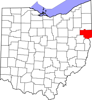 Map of Ohio highlighting Columbiana County | |
| Villages | ||
| Townships | ||
| CDPs | ||
| Unincorporated communities |
| |
| Ghost town | ||
| Footnotes | ‡This populated place also has portions in an adjacent county or counties | |
| Authority control |
|
|---|