Watkinsville, Georgia
Watkinsville is the largest town and county seat of Oconee County, Georgia, United States. As of the 2010 census, the town had a total population of 2,832.[5] It served as the seat of Clarke County until 1872 when the county seat of that county was moved to Athens, a move which ultimately led to the creation of Oconee County in 1875. It is included in the Athens-Clarke County, Georgia Metropolitan Statistical Area.
Watkinsville, Georgia | |
|---|---|
 Oconee County Courthouse in Watkinsville, Georgia | |
 Location in Oconee County and the state of Georgia | |
| Coordinates: 33°51′46″N 83°24′29″W | |
| Country | United States |
| State | Georgia |
| County | Oconee |
| Area | |
| • Total | 3.30 sq mi (8.55 km2) |
| • Land | 3.27 sq mi (8.46 km2) |
| • Water | 0.04 sq mi (0.10 km2) |
| Elevation | 719 ft (219 m) |
| Population (2010) | |
| • Total | 2,832 |
| • Estimate (2018)[2] | 2,911 |
| • Density | 891.58/sq mi (344.28/km2) |
| Time zone | UTC-5 (Eastern (EST)) |
| • Summer (DST) | UTC-4 (EDT) |
| ZIP code | 30677 |
| Area code(s) | 706 |
| FIPS code | 13-80788[3] |
| GNIS feature ID | 0333373[4] |
| Website | http://cityofwatkinsville.com/ |
Geography
Watkinsville is located at 33°51′46″N 83°24′29″W (33.862818, -83.408094).[6]
According to the United States Census Bureau, the town has a total area of 3.2 square miles (8.3 km2), of which 3.2 square miles (8.3 km2) is land and 0.31% is water.
Transportation
Pedestrians and cycling
The city has limited walkability options available. However, since 2017 plans are being discussed to develop a multi-use trail network. A new sidewalk on VFW Drive (and a few surrounding streets) and a planned sidewalk and pedestrian bridge along Harden Hill Road have changed that perception greatly. Phase I of the construction of the Harden Hill sidewalk was recently contracted and has begun to be finished by Christmas 2019.[7]
Demographics
| Historical population | |||
|---|---|---|---|
| Census | Pop. | %± | |
| 1810 | 224 | — | |
| 1870 | 643 | — | |
| 1880 | 350 | −45.6% | |
| 1890 | 314 | −10.3% | |
| 1900 | 351 | 11.8% | |
| 1910 | 483 | 37.6% | |
| 1920 | 465 | −3.7% | |
| 1930 | 425 | −8.6% | |
| 1940 | 558 | 31.3% | |
| 1950 | 662 | 18.6% | |
| 1960 | 758 | 14.5% | |
| 1970 | 986 | 30.1% | |
| 1980 | 1,240 | 25.8% | |
| 1990 | 1,600 | 29.0% | |
| 2000 | 2,097 | 31.1% | |
| 2010 | 2,832 | 35.1% | |
| Est. 2018 | 2,911 | [2] | 2.8% |
| U.S. Decennial Census[8] | |||
As of the census[3] of 2000, there were 2,097 people, 827 households, and 578 families residing in the town. The population density was 650.6 people per square mile (251.4/km²). There were 862 housing units at an average density of 267.4 per square mile (103.4/km²). The racial makeup of the town was 89.08% White, 7.34% African American, 0.05% Native American, 1.62% Asian, 0.48% Pacific Islander, 0.86% from other races, and 0.57% from two or more races. Hispanic or Latino of any race were 1.96% of the population.
There were 827 households out of which 36.5% had children under the age of 18 living with them, 53.6% were married couples living together, 12.7% had a female householder with no husband present, and 30.1% were non-families. 24.4% of all households were made up of individuals and 8.5% had someone living alone who was 65 years of age or older. The average household size was 2.51 and the average family size was 2.99.
In the town, the population was spread out with 26.8% under the age of 18, 8.6% from 18 to 24, 33.0% from 25 to 44, 22.7% from 45 to 64, and 8.9% who were 65 years of age or older. The median age was 34 years. For every 100 females, there were 92.7 males. For every 100 females age 18 and over, there were 91.5 males.
The median income for a household in the town was $45,729, and the median income for a family was $55,170. Males had a median income of $32,295 versus $26,168 for females. The per capita income for the town was $20,968. About 3.8% of families and 5.0% of the population were below the poverty line, including 5.9% of those under age 18 and 4.7% of those age 65 or over.
History
The Georgia General Assembly incorporated Watkinsville in 1815.[9] On 30 June 1905, Watkinsville saw one of the worse outbreaks of racial violence ever in Georgia when 8 men, 7 of whom were black, were pulled out of the local jail and lynched.[10]
Government
Watkinsville is governed by a five-person elected city council, which is led by a separately elected mayor. The current mayor is Bob Smith, and the current city council members are Brian Brodrick, Connie Massey, Marcia Campbell, Christine Tucker, and Daniel Matthews. All three incumbents won re-election in 2018 (Post 3's Campbell, Post 4's Tucker, and Post 5's Matthews). Shearon requalified to run for a second term against former State Rep. Bob Smith, with Smith winning a contentious election by two votes, 402-400. Connie Massey defeated Jonathan Kirkpatrick in the November 2019 municipal election, although Kirkpatrick has agreed to serve on the Planning Commission for the City. The newly appointed chief of police is Shannon Brock. The city clerk is Julie Sanders. The City Manager is Sharyn Dickerson, formerly an Athens-Clarke Commissioner.[11]
Education
The Oconee County School District provides primary and secondary public education services for all residents of Watkinsville.[12] The only public schools within the Watkinsville city limits are Colham Ferry Elementary School, Oconee County Elementary School, Oconee County Primary School, Oconee County Middle School, and Oconee County High School.
Arts and culture
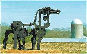
Watkinsville has the unofficial motto "The Artland of Georgia" on the wall of the Community Center, as designed by the late artist Jim Shearon.[13] The Oconee Cultural Arts Foundation or OCAF is located in Watkinsville in the old high school as part of the 1902 OCAF Center and Gallery near the Board of Education. The Iron Horse sculpture stands in a field approximately twelve miles south of Watkinsville (barely in Greene County).[14]
Notable people
- Nathan Crawford Barnett, member of the Georgia House of Representatives and Georgia Secretary of State for more than 30 years.
- Alan Busenitz, baseball player
- Ed Crowley, baseball player
- Atticus Haygood, Methodist Bishop and president
- Hank Huckaby, chancellor of University System of Georgia
- Zach Mettenberger, NFL quarterback for Tennessee Titans
- Jeannette Rankin, an American politician and women's rights advocate, she founded the Georgia Peace Society in 1928.
- Tony Taylor, pro football player
- Buck Thrasher, baseball player
- John Wes Townley, retired NASCAR driver, notable for driving Zaxby's car
References
- "2018 U.S. Gazetteer Files". United States Census Bureau. Retrieved Feb 12, 2020.
- "Population and Housing Unit Estimates". Retrieved June 4, 2019.
- "U.S. Census website". United States Census Bureau. Retrieved 2008-01-31.
- "US Board on Geographic Names". United States Geological Survey. 2007-10-25. Retrieved 2008-01-31.
- 2010 Census Population Map
- "US Gazetteer files: 2010, 2000, and 1990". United States Census Bureau. 2011-02-12. Retrieved 2011-04-23.
- "Plans for Oconee County taking shape". Gate House Media LLC. 2017-06-14. Retrieved 2018-05-21.
- "Census of Population and Housing". Census.gov. Retrieved June 4, 2015.
- "Watkinsville". GeorgiaGov. Retrieved 29 June 2019.
- Thompson, Adam (22 November 2007). "Group to look for lost graves from notorious 1905 lynching". Savannah Morning News. Retrieved 29 March 2020.
- http://cityofwatkinsville.com/personnel-directory/Committees
- Georgia Board of Education, Retrieved June 24, 2010.
- Matthews Jr., Daniel J (April 28, 2004). "City residents voice concerns over streets | Online Athens". onlineathens.com. Retrieved January 17, 2017.
- Shearer, Lee (3 June 2015). "Iconic Iron Horse's hooves eaten by rust, but will be repaired". Retrieved 25 June 2016.
External links
Municipalities and communities of Oconee County, Georgia, United States | ||
|---|---|---|
| Towns | 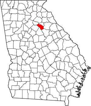 Map of Georgia highlighting Oconee County | |
| Unincorporated communities | ||
| Ghost town | ||
| Footnotes | ‡This populated place also has portions in an adjacent county or counties | |
| Authority control |
|
|---|