Wallumbilla, Queensland
Wallumbilla is a town and locality in the Maranoa Region, Queensland, Australia.[2][3] In the 2016 census, Wallumbilla had a population of 388 people for the locality with 191 people living in the town itself.[1][4]
| Wallumbilla Queensland | |||||||||||||||
|---|---|---|---|---|---|---|---|---|---|---|---|---|---|---|---|
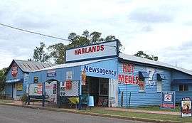 Newsagency and general store | |||||||||||||||
 Wallumbilla | |||||||||||||||
| Coordinates | 26.5869°S 149.1863°E | ||||||||||||||
| Population | 388 (2016 census)[1] | ||||||||||||||
| • Density | 3.678/km2 (9.525/sq mi) | ||||||||||||||
| Postcode(s) | 4428 | ||||||||||||||
| Elevation | 320 m (1,050 ft) | ||||||||||||||
| Area | 105.5 km2 (40.7 sq mi) | ||||||||||||||
| Location | |||||||||||||||
| LGA(s) | Maranoa Region | ||||||||||||||
| State electorate(s) | Warrego | ||||||||||||||
| Federal Division(s) | Maranoa | ||||||||||||||
| |||||||||||||||
Geography
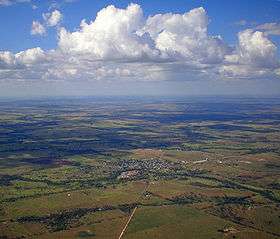
Wallumbilla is situated on the Warrego Highway, five hours by road west from Brisbane, just east of Roma in South West Queensland.[5]
To the north of Wallumbilla the Great Dividing Range (in this region no more than a bumpy watershed) passes roughly ESE to NNW. The town is sandwiched between Wallumbilla & Middle Creeks as they flow south toward the Condamine/Balonne River.[5]
Wallumbilla is on the Western railway line and was served by the now non-operational Wallumbilla railway station.[5]
History
The name Wallumbilla was the name of a pastoral run leased by Charles Coxen, The name is presumed to come from the indigenous Mandandanji language and reportedly means wallu=plenty and billa=jew fish.[2][3]
Wallumbilla Provisional School opened on 25 October 1893, becoming Wallumbilla State School on 1 September 1894.[6]
At the 2006 census, Wallumbilla had a population of 285.[7]
In the 2011 census, Wallumbilla had a population of 262 people.[8]
Heritage listings
Wallumbilla has a number of heritage-listed sites, including:
- George Street: Nostalgic Queen's Theatre[9]
Amenities
Wallumbilla's Calico Cottage, open seven days a week, is the town's Visitor Information Centre. As well as this, Calico Cottage sells locally produced arts and crafts along with refreshments.

The town also contains three churches, as well as a Masonic Hall. Other amenities include a hotel/pub, a news agency, and a petrol station.
Wallumbilla has a heritage complex and visitor information centre. A Public Library operates in Wallumbilla in George Street.[10]
The Wallumbilla branch of the Queensland Country Women's Association has its rooms at 15 College Street.[11]
Education
Wallumbilla State School is a primary and secondary school (P-10) for boys and girls operated by the Queensland Government at 22 High Street. In 2016, the school had an enrolment of 106 students with 15 teachers (12 full-time equivalent) and 10 non-teaching staff (7 full-time equivalent).[12] Most of these students hail from properties surrounding town, as well as the high school students who attended primary school in the neighbouring town of Yuleba. The nearest state high schools offering Years 11 and 12 of secondary school are in Roma (40 km west) and Miles (90 km east).[5]
Economy
Traditionally Wallumbilla's main industries were dairy and beef cattle, now the main industries are cropping and beef cattle. The main crops include sorghum and wheat.
Locals believe that if not for the discovery of gas at nearby hub Roma, Wallumbilla would have flourished into a similar hub, as the discovery of gas in 1908 near Roma preluded the Wallumbilla cattle sale yards (a thriving business according to local history) to move up to Roma, accentuating its growth.
A major gas hub is in preparation for Wallumbilla, planned to start operation in 2014.[13]
References
- Australian Bureau of Statistics (27 June 2017). "Wallumbilla (State Suburb)". 2016 Census QuickStats. Retrieved 21 November 2017.

- "Wallumbilla - town (entry 36362)". Queensland Place Names. Queensland Government. Retrieved 18 August 2016.
- "Wallumbilla - locality (entry 47462)". Queensland Place Names. Queensland Government. Retrieved 18 August 2016.
- Australian Bureau of Statistics (27 June 2017). "Wallumbilla (Urban Centre)". 2016 Census QuickStats. Retrieved 21 November 2017.
- "Queensland Globe". State of Queensland. Retrieved 21 November 2017.
- Queensland Family History Society (2010), Queensland schools past and present (Version 1.01 ed.), Queensland Family History Society, ISBN 978-1-921171-26-0
- Australian Bureau of Statistics (25 October 2007). "Wallumbilla (L) (Urban Centre/Locality)". 2006 Census QuickStats. Retrieved 29 November 2008.
- Australian Bureau of Statistics (31 October 2012). "Wallumbilla (SSC)". 2011 Census QuickStats. Retrieved 17 August 2016.
- "Nostalgic Queen's Theatre (entry 602378)". Queensland Heritage Register. Queensland Heritage Council. Retrieved 11 July 2013.
- "Wallumbilla Library". plconnect.slq.qld.gov.au. Retrieved 17 January 2018.
- "Branch locations". Queensland Country Women's Association. Archived from the original on 26 December 2018. Retrieved 26 December 2018.
- "2016 Annual Report" (PDF). Wallumbilla State School. Archived (PDF) from the original on 21 November 2017. Retrieved 21 November 2017.
- "Gas Supply Hub". Australian Energy Market Operator. Retrieved 18 February 2014.
External links
| Wikimedia Commons has media related to Wallumbilla, Queensland. |
- University of Queensland: Queensland Places: Wallumbilla
- Maranoa Online A portal servicing the Maranoa - a region encompassing Wallumbilla