Viñales
Viñales is a small town and municipality in the north-central Pinar del Río Province of Cuba. The town consists mostly of one-story wooden houses with porches. The municipality is dominated by low mountain ranges of the Cordillera de Guaniguanico such as Sierra de los Órganos. Typical outcrops known as mogotes complete the karstic character of the landscape.[3]
Viñales | |
|---|---|
.jpg) | |
.png) Viñales municipality (red) within Pinar del Río Province (yellow) and Cuba | |
| Coordinates: 22°36′55″N 83°42′57″W | |
| Country | Cuba |
| Province | Pinar del Río |
| Settled | 1871 |
| Established | 1878 |
| Area | |
| • Total | 704 km2 (272 sq mi) |
| Elevation | 135 m (443 ft) |
| Population (2004)[2] | |
| • Total | 27,129 |
| • Density | 38.5/km2 (100/sq mi) |
| Time zone | UTC-5 (EST) |
| Area code(s) | +53-48 |
North of the town is the Viñales Valley, a UNESCO World Heritage Site.
History
Before European settlement, the area was the home of a remnant Taíno population swelled with runaway slaves.[4] The area was colonised at the beginning of the 1800s by tobacco growers from the Canary Islands, who settled in the Vuelta Abajo region. The first colonial settlement in Viñales is documented in 1871, in the form of a ranch belonging to Andrés Hernández Ramos. The town was established in 1878 as a typical community, with church, school, hospital and recreation park.[5]
Economy
.jpg)
Viñales is an agricultural area, where crops of fruit, vegetables, coffee and especially tobacco are grown by traditional methods. Fishing is also an important part of the area's economy.
Tourism
Tourism centered on the Viñales Valley is developing, the area being protected by constitution since February 1976, and declared a national monument in October 1978. The Viñales Valley has been listed as a UNESCO World Heritage Site since November 1999,[6] for the outstanding karst landscape and traditional agriculture as well as vernacular architecture, crafts and music.
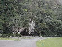
Attractions in Viñales include the Viñales Municipal Museum, Casa de Caridad Botanical Gardens, Museo Paleontológico, Palenque (a Maroon village)[4] and the nearby caves (Cueva del Indio, Cueva de José Miguel, Cueva de Santo Tomás) in Valle de Viñales National Park,[7] which were refuges for runaway slaves.[4] There is also a cave that doubles as a nightclub.
Casas particulares (private residences that have been tailored and licensed to operate as bed and breakfasts) offer accommodations to visitors year-round. There are also three hotels located a few kilometers outside of town, rated three stars: La Ermita, Los Jazmines, and Rancho Horizontes San Vicente. The campismo Dos Hermanas comprises 54 cabins (available to tourists), a swimming pool and restaurante..
Climate
Viñales has a tropical monsoon climate according to the Köppen climate classification, with a hot, lengthy wet season, and a warm and relatively short dry season. The average temperatures range from highs of 31.7°C and lows of 22°C in July and August to 26.2°C and 16.1°C in February. April-November represents the wet season, being especially wet May-October. December-March is the dry season, however only December and March qualify as true dry season months, as the threshold for such a month is less than 60 millimeters. The rainiest month in Viñales is June, with 226 millimeters, and the driest is December with 50 millimeters.
| Climate data for Viñales | |||||||||||||
|---|---|---|---|---|---|---|---|---|---|---|---|---|---|
| Month | Jan | Feb | Mar | Apr | May | Jun | Jul | Aug | Sep | Oct | Nov | Dec | Year |
| Average high °C (°F) | 26.4 (79.5) |
26.2 (79.2) |
28.1 (82.6) |
30.0 (86.0) |
30.8 (87.4) |
30.8 (87.4) |
31.7 (89.1) |
31.7 (89.1) |
31.2 (88.2) |
29.9 (85.8) |
27.9 (82.2) |
26.8 (80.2) |
29.3 (84.7) |
| Daily mean °C (°F) | 21.3 (70.3) |
21.1 (70.0) |
22.8 (73.0) |
24.6 (76.3) |
25.7 (78.3) |
26.3 (79.3) |
26.8 (80.2) |
26.8 (80.2) |
26.5 (79.7) |
25.3 (77.5) |
23.1 (73.6) |
21.7 (71.1) |
24.3 (75.8) |
| Average low °C (°F) | 16.3 (61.3) |
16.1 (61.0) |
17.6 (63.7) |
19.3 (66.7) |
20.7 (69.3) |
21.8 (71.2) |
22.0 (71.6) |
22.0 (71.6) |
21.8 (71.2) |
20.8 (69.4) |
18.4 (65.1) |
16.6 (61.9) |
19.5 (67.0) |
| Average rainfall mm (inches) | 60 (2.4) |
62 (2.4) |
56 (2.2) |
83 (3.3) |
173 (6.8) |
226 (8.9) |
184 (7.2) |
207 (8.1) |
216 (8.5) |
151 (5.9) |
72 (2.8) |
50 (2.0) |
1,540 (60.5) |
| Source: Climate-Data.org | |||||||||||||
Demographics
In 2004, the municipality of Viñales had a population of 27,129 with a 0.69%/year increase.[2] With a total area of 704 km2 (272 sq mi),[1] it has a population density of 38.5/km2 (100/sq mi).
Gallery
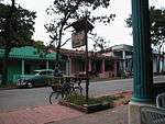 A man rides down the main street in Viñales
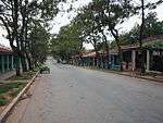 Downtown Viñales
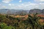 Viñales Valley
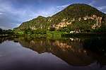 View of lake and Mogote at Viñales
References
- Statoids (July 2003). "Municipios of Cuba". Retrieved 2007-10-07.
- Atenas.cu (2004). "2004 Population trends, by Province and Municipality" (in Spanish). Archived from the original on 2007-09-27. Retrieved 2007-10-07.
- Cuba Junky. Vinales
- Guerrillero:Pinar del Río. "El Templo de los Cimarrones" Archived 2008-05-08 at the Wayback Machine (in Spanish)
- Vinales.cu History
- UNESCO World Heritage - Vinales Valley
- "Valle de Viñales: Monumento Natural de Cuba"
External links
| Wikimedia Commons has media related to Viñales. |
| Wikivoyage has a travel guide for Viñales. |
- Viñales Municipality (in Spanish)
- "Valle Son Music" A collection of son and salsa groups performing in Viñales
- "Viñales Tours & Accommodation" Tourist information on the town of Viñales
- "Viñales, Land to Dream" Viñales Page Information
- Viñales information about Casas Particulares Viñales Page about tourism Information and Casas Particulares
Places adjacent to Viñales | |
|---|---|