Van Fortress
The Fortress of Van (Armenian: Վանի Բերդ, also known as Van Citadel, Turkish: Van Kalesi or Kurdish: Kela Wanê) is a massive stone fortification built by the ancient kingdom of Urartu during the 9th to 7th centuries BC, and is the largest example of its kind. It overlooks the ruins of Tushpa the ancient Urartian capital during the 9th century which was centered upon the steep-sided bluff where the fortress now sits. A number of similar fortifications were built throughout the Urartian kingdom, usually cut into hillsides and outcrops in places where modern-day Armenia, Turkey and Iran meet. Successive groups such as the Medes, Achaemenids, Armenians, Parthians, Romans, Sassanid Persians, Byzantines, Arabs, Seljuks, Safavids, Afsharids, Ottomans and Russians each controlled the fortress at one time or another. The ancient fortress is located just west of Van and east of Lake Van in the Van Province of Turkey.
| Van Fortress | |
|---|---|
| Van, Turkey | |
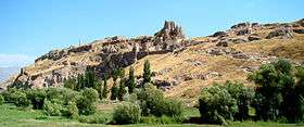 Van Fortress as seen from the northwest. | |
 Van Fortress  Van Fortress | |
| Coordinates | 38.50321°N 43.339133°E |
| Type | Fortress |
| Site information | |
| Open to the public | Yes |
| Condition | Large sections of walls are still standing. |
| Site history | |
| Built | 8th and 7th centuries BC |
| Materials | Unmortared basalt (lower walls) and mud-bricks |
| Demolished | Partially |
Silva Tipple New Lake led an American expedition to the ruins in 1938-40.[1] Most of the finds and field records from this were lost in the sinking of the S.S. Athenia in 1940.
The lower parts of the walls of Van Citadel were constructed of unmortared basalt, while the rest was built from mud-bricks.
Such fortresses were used for regional control, rather than as a defense against foreign armies. The ruins of this fortress sit outside the modern city of Van, where they support walls built in the medieval era.[2]
Achaemenid inscription
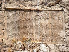
A stereotyped trilingual inscription of Xerxes the Great from the 5th century BC is inscribed upon a smoothed section of the rock face, some 20 meters (60 feet) above the ground near the fortress. The niche was originally carved out by Xerxes' father King Darius, but left the surface blank. The inscription survives in near perfect condition and is divided into three columns of 27 lines written in (from left to right) Old Persian, Babylonian, and Elamite.
Gallery
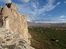 Citadel with the ruins of the city of Tushpa below.
 Van Fortress
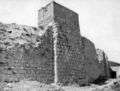 The walls of the fortress (Russian Archeological Society, 1916).
 Annals of Sarduri (1915).
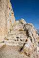 Stairs at the fortress.
References
- Who Was Who in America, v. 5, 1969–1973 https://books.google.com/books?ei=KItvTuLtHcjh0QGj8uWCCg&ct=result&id=jHXhAAAAMAAJ&q=tipple
- The Seventy Wonders of the Ancient World
- Çiftçi, Ali (2017). The Socio-Economic Organisation of the Urartian Kingdom. Brill. pp. 113–114. ISBN 9789004347588.
External links
| Wikimedia Commons has media related to Van Fortress. |
Cities and fortresses of Urartu (Kingdom of Van) | ||
|---|---|---|
1 First capital city until 832 B.C. 2 Second capital city from 832 B.C. | ||