Uda, Nara
Uda (宇陀市, Uda-shi) is a city located in northeastern Nara Prefecture, Japan.
Uda 宇陀市 | |
|---|---|
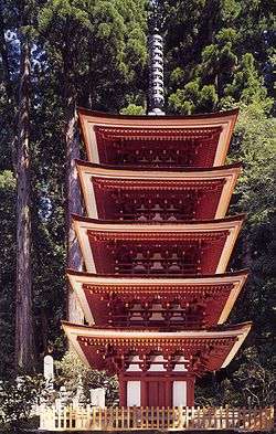 View of Muro Temple | |
 Flag  Emblem | |

Location of Uda in Nara Prefecture | |
 | |
 Uda Location in Japan | |
| Coordinates: 34°31′N 135°58′E | |
| Country | Japan |
| Region | Kansai |
| Prefecture | Nara Prefecture |
| Government | |
| • Mayor | Mikio Takeuchi |
| Area | |
| • Total | 247.62 km2 (95.61 sq mi) |
| Population (April 1, 2015) | |
| • Total | 31,274 |
| Symbols | |
| • Tree | Hinoki |
| • Flower | Lily of the Valley |
| • Bird | Nightingale |
| Time zone | UTC+9 (JST) |
| City hall address | 17-3 Shimoidari, Haibara-ku, Uda-shi, Nara-ken 633-0292 |
| Website | www |
The modern city of Uda was established on January 1, 2006, the towns of Haibara, Ōuda and Utano, and the village of Murō (all from Uda District).
As of December 29, 2005, the city had an estimate population of 38,648 and a population density of 155.35 persons per km². As of April 1, 2015, the city has an estimated population of 31,274 and 13,128 households. The population density is 145.64 persons per km², and the total area is 247.62 km².
Each former town became a ward. The wards here are ordinary wards of a city, unlike the 23 special wards of Tokyo.
Geography
Located in the Yamato Plateau in northeastern Nara Prefecture, it is surrounded by mountains in all directions. The Kintetsu Osaka Line has a major role in transportation in Uda.
Neighboring municipalities
Climate
Uda has a humid subtropical climate (Köppen climate classification Cfa), which is hot and humid in the summer (above 30 °C (86 °F)) and is somewhat cold in the winter with temperatures dropping to around freezing (0 °C (32 °F)).
| Climate data for Ōuda (Ōuda Uda, elevation 349 m (1,145 ft)) | |||||||||||||
|---|---|---|---|---|---|---|---|---|---|---|---|---|---|
| Month | Jan | Feb | Mar | Apr | May | Jun | Jul | Aug | Sep | Oct | Nov | Dec | Year |
| Record high °C (°F) | 18.2 (64.8) |
21.5 (70.7) |
23.4 (74.1) |
28.8 (83.8) |
31.9 (89.4) |
33.6 (92.5) |
35.4 (95.7) |
36.3 (97.3) |
35.1 (95.2) |
30.6 (87.1) |
25.7 (78.3) |
23.7 (74.7) |
36.3 (97.3) |
| Average high °C (°F) | 6.8 (44.2) |
7.7 (45.9) |
11.7 (53.1) |
18.1 (64.6) |
22.6 (72.7) |
25.7 (78.3) |
29.3 (84.7) |
30.6 (87.1) |
26.6 (79.9) |
20.5 (68.9) |
15.0 (59.0) |
9.6 (49.3) |
18.7 (65.7) |
| Daily mean °C (°F) | 1.9 (35.4) |
2.4 (36.3) |
5.6 (42.1) |
11.3 (52.3) |
16.2 (61.2) |
20.2 (68.4) |
24.0 (75.2) |
24.7 (76.5) |
21.0 (69.8) |
14.6 (58.3) |
9.0 (48.2) |
4.0 (39.2) |
12.9 (55.2) |
| Average low °C (°F) | −2.4 (27.7) |
−2.4 (27.7) |
−0.1 (31.8) |
4.6 (40.3) |
10.1 (50.2) |
15.4 (59.7) |
19.7 (67.5) |
20.1 (68.2) |
16.5 (61.7) |
9.4 (48.9) |
3.6 (38.5) |
−0.8 (30.6) |
8.7 (47.7) |
| Record low °C (°F) | −8.7 (16.3) |
−9.3 (15.3) |
−6.8 (19.8) |
−4.3 (24.3) |
−0.5 (31.1) |
5.3 (41.5) |
11.3 (52.3) |
11.8 (53.2) |
5.5 (41.9) |
−1.1 (30.0) |
−4.3 (24.3) |
−8.7 (16.3) |
−9.3 (15.3) |
| Average precipitation mm (inches) | 59.9 (2.36) |
70.2 (2.76) |
108.6 (4.28) |
105.0 (4.13) |
144.9 (5.70) |
198.5 (7.81) |
187.2 (7.37) |
136.6 (5.38) |
182.9 (7.20) |
133.3 (5.25) |
87.2 (3.43) |
57.5 (2.26) |
1,469.3 (57.85) |
| Mean monthly sunshine hours | 96.2 | 106.6 | 135.2 | 150.1 | 159.2 | 123.8 | 145.1 | 154.7 | 112.8 | 113.1 | 105.6 | 100.3 | 1,504.8 |
| Source 1: Japan Meteorological Agency[1] | |||||||||||||
| Source 2: Japan Meteorological Agency[2] | |||||||||||||
Transportation
Rail
- Kintetsu Railway
- Osaka Line: Haibara Station - Murōguchiōno Station - Sambommatsu Station
References
- 大宇陀 年・月ごとの平年値 (in Japanese). Japan Meteorological Agency. Retrieved 25 April 2018.
- 大宇陀 観測史上1~10位の値 (in Japanese). Japan Meteorological Agency. Retrieved 25 April 2018.
External links


- Uda City official website (in Japanese)
Nara (capital) | ||
| Core city | ||
| Cities | ||
| Districts | ||
| Authority control |
|
|---|