Ōuda, Nara
Ōuda (大宇陀町, Ōuda-chō) was a town located in Uda District, Nara Prefecture, Japan.
Ōuda 大宇陀町 | |
|---|---|
Former municipality | |
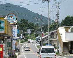 The main street in Ōuda | |
 Ōuda Location in Japan | |
| Coordinates: 34°28′44.2″N 135°55′41.1″E | |
| Country | Japan |
| Region | Kansai (Kinki) |
| Prefecture | Nara Prefecture |
| District | Uda |
| Merged | January 1, 2006 (now part of Uda) |
| Area | |
| • Total | 47.44 km2 (18.32 sq mi) |
| Population (2005) | |
| • Total | 8,647 |
| • Density | 180/km2 (470/sq mi) |
| Symbols | |
| • Tree | Oak |
| • Flower | Pinwheel |
| • Bird | Bunting |
| Time zone | UTC+9 (JST) |
| Website | City of Uda |
As of 2005, the town had an estimated population of 8,647 and a density of 182.27 persons per km². The total area was 47.44 km².
On January 1, 2006, Ōuda, along with the towns of Haibara and Utano (all from Uda District), was merged to create the city of Uda.
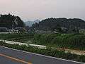
The town of Ōuda lies in a valley between two long mountain ranges in northeastern Nara, Japan. A three-mile long stretch of national routes 166 and 370 in the southern part of the town is where most of the businesses and homes are clustered. A large portion of flat land north on route 370 is less densely populated, covered mostly by rice fields. A large torii, or Japanese Gate, rises out of the rice paddies.
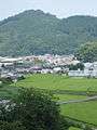
 The outskirts of Ōuda
| Authority control |
|
|---|