Tawaramoto, Nara
Tawaramoto (田原本町, Tawaramoto-chō) is a town located in Shiki District, Nara Prefecture, Japan.
Tawaramoto 田原本町 | |
|---|---|
Town | |
 Tawaramoto Town Office | |
 Flag  Chapter | |
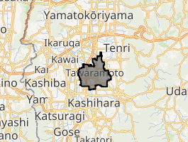
Location of Tawaramoto in Nara Prefecture | |
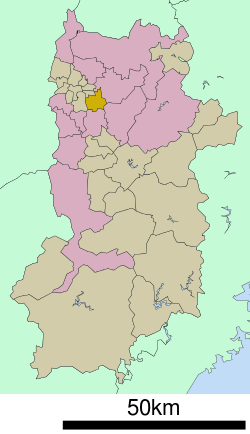 | |
 Tawaramoto Location in Japan | |
| Coordinates: 34°33′N 135°48′E | |
| Country | Japan |
| Region | Kansai |
| Prefecture | Nara Prefecture |
| District | Shiki |
| Area | |
| • Total | 21.09 km2 (8.14 sq mi) |
| Population (March 31, 2017) | |
| • Total | 32,241 |
| • Density | 1,500/km2 (4,000/sq mi) |
| Symbols | |
| • Tree | Quercus Gilva |
| • Flower | Narcissus |
| Time zone | UTC+9 (JST) |
| City hall address | 890-1 Tawarmoto-chō, Nara-ken 636-0392 |
| Website | www |
As of March 31, 2017, the town has an estimated population of 32,241.[1] The total area is 21.09 km².[2] It has many temples and shrines including Jinrakuji.
Geography
Located in the center of the Nara Basin, the majority of the land is flat. The Yamato River flows through the eastern portion of the town.
Education
- Tawaramoto Agriculture School
- Koutou Special School
- Shiki High School
References
- "Population of Tawaramoto Town" (in Japanese). Japan: Tawaramoto Town. Retrieved 23 April 2017.
- "Nature of Tawaramoto Town" (in Japanese). Japan: Tawaramoto Town. Retrieved 23 April 2017.
External links


- Tawaramoto official website (in Japanese)
Nara (capital) | ||
| Core city | ||
| Cities | ||
| Districts | ||
| Authority control |
|
|---|
This article is issued from Wikipedia. The text is licensed under Creative Commons - Attribution - Sharealike. Additional terms may apply for the media files.