Tropical Storm Arthur (2020)
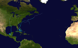
Tropical Storm Arthur was a relatively strong off-season tropical storm that impacted the U.S state of North Carolina in May 2020. The first depression and first named storm of the 2020 Atlantic hurricane season, Arthur marked the record sixth consecutive year in the Atlantic basin with an early start before June. It was one of two off-season storms in the season, alongside short-lived Tropical Storm Bertha. Originating from a broad trough that formed on May 14 near Cuba, the early system slowly drifted south of Florida through the Florida Strait for two days, before becoming a depression on May 16 north of The Bahamas, starting the Atlantic season. A day later, the system would be named Arthur and slowly drift north towards the Outer Banks of North Carolina, before skirting the same area and weakening as it moved towards Bermuda.
| Tropical storm (SSHWS/NWS) | |
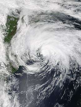 Arthur off the east coast of North Carolina near peak intensity on May 18 | |
| Formed | May 16, 2020 |
|---|---|
| Dissipated | May 20, 2020 |
| (Extratropical after May 19) | |
| Highest winds | 1-minute sustained: 60 mph (95 km/h) |
| Lowest pressure | 991 mbar (hPa); 29.26 inHg |
| Fatalities | None |
| Damage | Minimal |
| Areas affected | Cuba, South Florida, The Bahamas, North Carolina, Bermuda |
| Part of the 2020 Atlantic hurricane season | |
In its formative stages, Arthur delivered heavy rainfall to the Florida Keys and South Florida, and also caused rough surf off the majority off the east coast of Florida. The system's outer bands would also begin to cause significant rainfall and gusty winds off the Outer Banks of North Carolina, as well as rip currents along the majority of the Southeastern Coast.
Meteorological history

On May 12, the National Hurricane Center (NHC) first discussed the possibility of subtropical development north of the Bahamas in the proceeding days related to a broad low pressure system that was expected to form near Cuba.[1] By May 13, thunderstorm activity began to increase in association with a developing trough near the western tip of Cuba, and the NHC considered the developing system to have a 70% chance of subtropical formation in the next five days,[2] although the associated shower and thunderstorm activity was not well organized.[3] Convection began to slowly build around the center by early May 16, and a well-defined low-level circulation (LLC) began to form displaced just slightly east of the main thunderstorms.[4] Based on this, the NHC upgraded the low to Tropical Depression One on the evening of May 16.[5] The system was considered tropical instead of subtropical in nature due to persisting central deep convection and a tight radius of winds.[5]
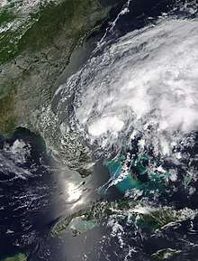
Based on reports from a Hurricane Hunter aircraft of tropical-storm force winds, the NHC upgraded the system to Tropical Storm Arthur at 03:00 UTC on May 17.[6] Being steered generally north-northeast for the next several hours, Arthur stayed well offshore of the coasts of Florida and Georgia.[7] However, a mid-level trough centered over the United States caused Arthur to slowly be pushed northeastwards over a section of relatively cool waters and as a result most of the storm's convection became limited to the east of the circulation.[8] Despite these unfavorable conditions, reconnaissance aircraft found Arthur slightly stronger, despite its appearance on satellite degrading significantly throughout the past few hours.[9] Deep convection began to swiftly re-develop over the center as the storm began to move over warmer waters of the Gulf Stream, resulting in strengthening.[10] On the afternoon of May 18, Arthur obtained its minimum central pressure of 991 mb (29.3 inHg) and its peak intensity of 60 mph (95 km/h).[11] As Arthur intensified, its center skirted the coast of the Outer Banks in North Carolina, passing a mere 20 mi (32 km) southeast from Cape Hatteras.[12] As a ridge strengthened to the north, Arthur began to be shoved away from the North Carolina coast and an increase in southwesterly shear as well as the beginning of extratropical transition began to separate the storm's main convective activity away from the LLC.[13] The storm completed this process on the morning of May 19, and became an extratropical cyclone as a trailing warm front developed behind the now almost fully exposed LLC.[14]
Preparations and impact
Although Arthur never directly impacted Florida as a tropical system, the precursor system to Arthur caused heavy rainfall and gusty winds in the Florida Keys and South Florida throughout May 13-14. Over 4 in (101.6 mm) of rain fell in many sections of the Middle Keys and a peak rainfall total of 5.35 in (135.8 mm) fell in Marathon on May 14, where it was the tenth highest rainfall amount for the city on record and second most for May.[15][16] Flash flood warnings were issued for large portions of Miami-Dade County on May 14, where street flooding was reported.[17] Tropical storm-force wind gusts as well as waterspouts prompted the issuance of gale warnings and special marine warnings across the majority of South Florida.[18] Rip currents in Florida led to the water rescues of 70 people in Volusia County, 3 of who were hospitalized.[19] Purple and red flags were raised along the coasts of Georgia and South Carolina to alert the public for rip currents.[20] Offshore Georgia, 3-6 ft (0.9-1.8 m) waves were reported.[21]
The precursor to Arthur dropped heavy rainfall in the Granma Province in Cuba on May 15, including 78 mm (3.07 in) of rainfall in Bayamo in only four hours. These rains resulted in flooded streets and significant damage to homes.[22] In the Bahamas, squalls occurred on Grand Bahama island, where many were still recovering from the adverse effects of Hurricane Dorian. Gusty winds damaged tents and other temporary shelters across the island, and heavy rainfall caused some minimal flooding.[23] However, since the strongest winds of the disturbance were located to the east of the center, damage was limited.[24]
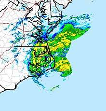
On May 16, tropical storm watches were issued from Surf City to Duck and Pamlico Sound to Albemarle Sound.[25] A day later, these watches were upgraded to tropical storm warnings as Arthur moved closer towards the Outer Banks.[26] By late May 17, rough surf conditions were already being experienced on the southern portion of the Outer Banks.[27] Torrential rainfall occurred as Arthur's outer rainbands scraped eastern North Carolina,[28] with 4.92 in (125 mm) of rain falling in Newport within 6 hours, and many other locations recording at least 3 in (76 mm) of rain from the storm.[29] Tropical storm-force wind gusts in Cape Hatteras were also recorded, although the lopsided nature of the storm kept the strongest winds offshore.[30][28] Wave heights as high as 12.5 ft (3.8 m) were recorded from buoys along the coast of the Outer Banks from Arthur.[31] Due to flooding from Arthur, many highways in the Outer Banks and into mainland North Carolina were closed.[32] SpaceX was also forced to delay the launch of several Starlink internet satellites due to adverse weather from Arthur affecting the recovery fleet.[33] As Arthur moved away from the coast, tropical storm warnings were lifted as conditions gradually improved later in the evening.[34]
See also
- Other storms with the same name
- Hurricane Arthur (2014) – took a similar track and made a landfall in a similar location
- Tropical Storm Ana (2015) – made landfall at a similar time
- Tropical Storm Arthur (1996) – another storm with the same name and a similar track
- Tropical Storm Beryl (2012) – the strongest storm to make landfall in the United States in May
- List of North Carolina hurricanes
- List of off-season Atlantic hurricanes
References
- "Special Tropical Weather Outlook 1005 AM EDT Tue May 12 2020". National Hurricane Center. Retrieved May 17, 2020.
- "Special Tropical Weather Outlook Special Tropical Weather Outlook". National Hurricane Center. Retrieved May 17, 2020.
- "Special Tropical Weather Outlook 725 PM EDT Wed May 13 2020". National Hurricane Center. Retrieved May 17, 2020.
- "NHC Graphical Outlook Archive". www.nhc.noaa.gov. Retrieved May 17, 2020.
- Cangialosi, John. "Tropical Depression One Discussion Number 1". National Hurricane Center. Retrieved May 17, 2020.
- Stewart, Stacy. "Tropical Storm Arthur Discussion Number 2". National Hurricane Center. Retrieved May 17, 2020.
- Pasch, Richard. "Tropical Storm Arthur Intermediate Advisory Number 2A". National Hurricane Center. Retrieved May 17, 2020.
- Pasch, Richard. "Tropical Storm Arthur Discussion Number 3". National Hurricane Center. Retrieved May 17, 2020.
- Brown, Daniel. "Tropical Storm Arthur Discussion Number 4". National Hurricane Center. Retrieved May 18, 2020.
- Brown, Daniel. "Tropical Storm Arthur Discussion Number 8". National Hurricane Center. Retrieved May 18, 2020.
- Brown, Daniel. "Tropical Storm Arthur Advisory Number 10". Retrieved May 18, 2020.
- Stewart, Stacy (May 18, 2020). "Tropical Storm Arthur Advisory Number 8". Retrieved May 29, 2020.
- "Tropical Storm Arthur Forecast Discussion Number 9". www.nhc.noaa.gov. Retrieved May 18, 2020.
- Blake, Eric. "Post-Tropical Cyclone Arthur Discussion Number 12". National Hurricane Center.
- "First Depression or Storm of 2020 Atlantic Hurricane Season, Possibly Arthur, To Form Off Southeast Coast This Weekend". The Weather Channel.
- "The rainfall record in #MarathonFL was crushed today! As of 6 pm, 5.35" had been recorded, which is over 4" more than the previous record of 1.20" set in 1988! It's also the 2nd wettest day in May and the 10th wettest day ever. #flwx #FloridaKeys #KeyWest #RecordRainfall #weatherpic.twitter.com/SosQ92zOpm". @NWSKeyWest. May 14, 2020. Retrieved May 18, 2020.
- Meteorologist, Allison Chinchar, CNN. "Arthur, the first named storm of the hurricane season, could form Saturday". CNN. Retrieved May 18, 2020.
- Cohen, Howard. "Flood and wind advisories issued for South Florida, and the storms could spawn tornadoes". The Miami Herald. Retrieved May 18, 2020.
- "This year's first Atlantic storm Arthur will bring high surf, strong winds and heavy rains to the North Carolina coast". www.wrcbtv.com. Retrieved May 18, 2020.
- "Tropical Storm Arthur Churning Off Georgia Coast". May 18, 2020. Retrieved May 18, 2020.
- "Wetter weather returns this week!". www.wtoc.com. Retrieved May 18, 2020.
- "Lluvias intensas provocan inundaciones en Bayamo". ADN Cuba (in Spanish). Retrieved May 18, 2020.
- "Tropical weather conditions expected to hit Grand Bahama". www.tribune242.com. Retrieved May 18, 2020.
- Norcross, Bryan (May 15, 2020). "Messy system near South Florida still forecast to organize". WPLG. Retrieved May 18, 2020.
- Cangialosi, John. "Tropical Depression One Advisory Number 1".
- "Tropical Storm Arthur Advisory Number 3".
- "Tropical Storm Arthur crawls closer to North Carolina coast". The Associated Press.
- Cappucci, Matthew (May 18, 2020). "Tropical Storm Arthur lashes Outer Banks with heavy rain, high surf". Washington Post. ISSN 0190-8286. Retrieved May 18, 2020.
- "Public Information Statement: PRECIPITATION REPORTS 1055 AM EDT Mon May 18 2020". National Weather Service.
- "Public Information Statement: HIGHEST WIND REPORTS 237 PM EDT Mon May 18 2020". National Weather Service.
- "Tropical Storm Arthur flirts with landfall over NC Outer Banks" (May 18, 2020). AccuWeather.
- "Tropical Storm Arthur hits North Carolina coast with rain". The Sun Sentinel.
- May 2020, Chelsea Gohd 18. "SpaceX postpones Starlink satellite fleet launch due to Tropical Storm Arthur". Space.com. Retrieved May 18, 2020.
- "Tropical storm warning lifted as Arthur moves away from North Carolina's Outer Banks". The News & Observer.
External links
| Wikimedia Commons has media related to Tropical Storm Arthur (2020). |