Tornado outbreak of March 2–3, 2020
A small but deadly tornado outbreak affected West and Middle Tennessee on the night of March 2 and into the morning of March 3, 2020, including one that hit downtown Nashville and another that impacted areas in the western part of Cookeville. Twenty-five people were killed by the tornadoes,[2][3] more than 300 were injured, and more than 70,000 lost power in the storm. The path of the Nashville tornado was very similar to the one that hit East Nashville in 1998. A few additional tornadoes were also confirmed in Alabama, southeastern Missouri, and western Kentucky. Total damage from the event reached $1.606 billion according to the National Centers for Environmental Information.[1]
Part of the tornado outbreaks of 2020 | |
 Confirmed tornadoes received by the Storm Prediction Center as well as all the tornado warnings issued. | |
| Type | Tornado outbreak |
|---|---|
| Duration | March 2–3, 2020 |
| Tornadoes confirmed | 15 |
| Max. rating1 | EF4 tornado |
| Duration of tornado outbreak2 | 34 hours, 38 minutes |
| Highest winds |
|
| Damage | $1.606 billion (2020 USD)[1] |
| Power outages | 73,000 |
| Casualties | 25 fatalities (+1 indirect), 309 injuries |
| Areas affected | Tennessee, Alabama, Southern Kentucky, Southeastern Missouri |
| 1Most severe tornado damage; see Enhanced Fujita scale 2Time from first tornado to last tornado | |
Meteorological synopsis
The threat for severe weather across Middle Tennessee and surrounding areas was not forecast well in advance. The Storm Prediction Center (SPC) first issued a slight risk across northeastern Arkansas into the Tennessee Valley area in their 06:00 UTC March 2 outlook. In their forecast, the SPC noted that an unstable atmosphere was likely to materialize ahead of an approaching cold front, but that this environment would likely be contained by a capping inversion for most of the day.[4]
By the afternoon hours, the SPC expected the combination of rich moisture, modest wind shear, and cold mid-level temperatures to promote the formation of supercells with a primary risk of large hail. Some tornadic activity appeared possible overnight given an increase in low-level winds.[5] At 5:20 p.m. CST, the first tornado watch was issued from northern Arkansas northeastward into southern Indiana and western Kentucky as discrete storms began to develop.[6][7]
By 11:00 p.m. CST, as a surface low progressed northeastward through southern Missouri, sustained barometric pressure falls caused supercell storms to give way to an organized storm cluster that gradually weakened as it progressed into an area of less abundant moisture.[8] As convection weakened to the north, the SPC began to monitor areas farther south – encompassing eastern Arkansas, West Tennessee, and southwestern Kentucky – for reinvigorated thunderstorm development as the northern jet stream amplified southeastward into the risk area. Strong wind shear coupled with low instability was expected to promote activity with "a risk for severe hail, strong surface gusts and perhaps potential for a tornado or two."[9] At 11:20 p.m. CST, a localized tornado watch was issued across middle Tennessee.[10] In subsequent hours, a long-lived and intense supercell produced 10 tornadoes along the Interstate 40 corridor, including an EF2 tornado that touched down north of Camden, Tennessee, killing one person, a high-end EF3 tornado in the vicinities of Nashville and Lebanon, killing five people, and a violent EF4 tornado in the vicinity of Cookeville, killing an additional 19 people. A couple weaker tornadoes touched down in central Alabama a few hours later as the event wound down.
Confirmed tornadoes
| EFU | EF0 | EF1 | EF2 | EF3 | EF4 | EF5 | Total |
|---|---|---|---|---|---|---|---|
| 0 | 6 | 3 | 4 | 1 | 1 | 0 | 15 |
March 2 event
| EF# | Location | County / Parish | State | Start Coord. | Time (UTC) | Path length | Max width | Summary | Refs |
|---|---|---|---|---|---|---|---|---|---|
| EF1 | SW of Crofton to NW of Fruit Hill | Christian | KY | 37.0335°N 87.5005°W | 02:00–02:06 | 5.51 mi (8.87 km) | 400 yd (370 m) | A meteorologist observed this tornado as it crossed US 41 just south of Crofton. Four farm structures and two garages were either damaged or destroyed, and several homes sustained minor roof, window, and siding damage. Numerous trees were uprooted along the path. | [11] |
| EF1 | Idlewide to Holly Leaf | Gibson | TN | 36.0323°N 88.8275°W | 04:12–04:23 | 7.27 mi (11.70 km) | 100 yd (91 m) | This was the first tornado from the long-tracked Nashville supercell. Several homes and grain bins were damaged south of Bradford. Trees were downed as well. | [12] |
| EF0 | ESE of Broadwater to W of Risco | New Madrid | MO | 36.57°N 89.9°W | 04:15–04:18 | 3.06 mi (4.92 km) | 50 yd (46 m) | A narrow tornado was on the ground approximately three minutes, and was confirmed by chaser via photograph. The tornado produced no damage in an open, unplanted field, and was thus rated an EF0. | [13][14] |
| EF2 | Hico to Marlborough | Carroll | TN | 36.0811°N 88.5287°W | 04:41–04:57 | 14.8 mi (23.8 km) | 100 yd (91 m) | This was the second tornado from the long-tracked Nashville supercell. Homes, barns, and grain bins were damaged or destroyed along the path. A few of these homes had their roofs torn off, and one sustained collapse of its exterior walls. Numerous trees were downed as well. | [15] |
| EF2 | Liberty to Kentucky Lake South to ENE of Forest Hill | Benton, Humphreys | TN | 36.0928°N 88.1189°W | 05:05–05:31 | 18.72 mi (30.13 km) | 250 yd (230 m) | 1 death – This was the third tornado from the long-tracked Nashville supercell. Several homes sustained significant damage, some of which sustained roof loss and some collapse of exterior walls. A mobile home was destroyed, and multiple outbuildings were either damaged or destroyed as well. Hundreds of trees were downed along the path, especially as the tornado crossed the Tennessee River into Humphreys County. Two people were also injured in Benton County. | [16][17] |
| EF0 | McEwen to NNE of Few Chapel | Humphreys | TN | 36.1162°N 87.6482°W | 05:42–05:48 | 4.8 mi (7.7 km) | 50 yd (46 m) | This was the fourth tornado from the long-tracked Nashville supercell. It touched down just northwest of town and moved off to the east, damaging a small barn and causing roof damage to a house. Several trees were downed along the path. | [18] |
March 3 event
| EF# | Location | County / Parish | State | Start Coord. | Time (UTC) | Path length | Max width | Summary | Refs |
|---|---|---|---|---|---|---|---|---|---|
| EF2 | N of Allen Springs to SSW of Raley Ford | Warren, Allen | KY | 36.8500°N 86.3200°W | 06:15–06:18 | 2.7 mi (4.3 km) | 250 yd (230 m) | A brief, but strong low-end EF2 tornado embedded within a larger area of straight-line wind damage destroyed three barns, and caused significant roof and siding damage to two houses southeast of Alvaton. A horse trailer was thrown 70 yards (64 m), and over 500 trees were knocked down in all directions. | [19][20] |
| EF3 | SSW of Scottsboro to North Nashville to SE of Gordonsville | Davidson, Wilson, Smith | TN | 36.1717°N 86.9562°W | 06:32–07:35 | 60.13 mi (96.77 km) | 1,600 yd (1,500 m) | 5 deaths – See section on this tornado – This was the fifth tornado from the long-tracked Nashville supercell. 220 people were injured. | [21][22][23] |
| EF0 | WNW of Denny Seminary to S of Gentry | Smith, Putnam | TN | 36.1603°N 85.8056°W | 07:38–07:42 | 3.32 mi (5.34 km) | 50 yd (46 m) | This was the sixth tornado from the long-tracked Nashville supercell. It touched down after the Nashville EF3 lifted and moved across hilly terrain just north of Buffalo Valley. It caused roof damage to several homes in the St. Mary's and Rock Springs communities of Putnam County before dissipating just west of Stanton Road. Several outbuildings were damaged as well. | [24] |
| EF4 | Ensor to Double Springs to Cookeville | Putnam | TN | 36.1716°N 85.6618°W | 07:48–07:56 | 8.39 mi (13.50 km) | 900 yd (820 m) | 19 deaths – See section on this tornado – This was the seventh tornado from the long-tracked Nashville supercell. 87 people were injured. | [25] |
| EF0 | SSE of Caney Fork to Goffton | Putnam | TN | 36.1075°N 85.4461°W | 08:05–08:06 | 0.23 mi (0.37 km) | 25 yd (23 m) | This was the eighth tornado from the long-tracked Nashville supercell. It briefly touched down along US 70N in the Dry Valley area southeast of Cookeville and caused roof damage to a house, a metal garage, and an outbuilding. Several trees had large branches broken as well. | [26] |
| EF2 | SW of Rinnie to NW of Halfway | Cumberland | TN | 36.1399°N 85.0401°W | 08:25–08:35 | 10.07 mi (16.21 km) | 500 yd (460 m) | The was the ninth tornado produced by the Nashville supercell. It touched down along US 127, causing roof damage to a mobile home. It then destroyed two outbuildings, caused roof damage to two homes, and pushed over a power pole. Two more outbuildings were destroyed before the tornado continued into the Catoosa Wildlife Management Area, where extensive tree damage warranted a low-end EF2 rating before the tornado dissipated, although there is a possibility that the tornado track was longer. | [27] |
| EF0 | NNE of Frankfort to WNW of Shady Grove | Morgan | TN | 36.1264°N 84.799°W | 08:40–08:42 | 3.68 mi (5.92 km) | 200 yd (180 m) | The last tornado produced by the Nashville supercell. Numerous trees were snapped or uprooted and a metal carport was flipped. | [28] |
| EF0 | Southern Greensboro | Hale | AL | 32.6846°N 87.6226°W | 12:04–12:12 | 4.34 mi (6.98 km) | 220 yd (200 m) | A high-end EF0 tornado snapped or uprooted numerous trees along it's path. Some homes suffered damage to shingles and siding, as well as some minor structural damage. | [29] |
| EF1 | Lawley | Bibb | AL | 32.8648°N 87.0496°W | 12:28–12:38 | 6.21 mi (9.99 km) | 525 yd (480 m) | A high-end EF1 tornado blew a manufactured home off its foundation, displaced a vehicle, and snapped or uprooted several dozen trees. A few houses were damaged, and more trees were downed in a wooded area and near the Lawley Fire Department and Community Center. | [30] |
Nashville–Mount Juliet–Lebanon–Gordonsville, Tennessee
| EF3 tornado | |
|---|---|
 EF3 damage to a house in Nashville | |
| Max. rating1 | EF3 tornado |
| Highest winds |
|
| Damage | $1.504 billion (2020 USD) |
| Casualties | 5 fatalities, 220 injuries |
| 1Most severe tornado damage; see Enhanced Fujita scale | |
This high-end EF3 tornado touched down around 12:32 a.m. CST (06:32 UTC) in far western Davidson County along TN 251, seven miles (11 km) northeast of Pegram. Initially, just trees were downed as the tornado crossed the Cumberland River and moved through Bells Bend, where a barn was also destroyed. Damage along this initial segment of the path was rated EF0 to EF1. The tornado crossed the river a second time before heavily damaging the John C. Tune Airport and an industrial area along Centennial Boulevard at high-end EF2 strength. The airport sustained significant damage to its terminal and other buildings, with 17 metal hangars on the property destroyed. More than 90 aircraft parked at the airport, including charter jets, smaller airplanes, and a newsgathering helicopter operated by CBS affiliate WTVF, were destroyed.[31] Maintaining high-end EF2 strength, it crossed the SR 155 and struck the former Tennessee State Prison, which sustained considerable structural damage. A communications tower and metal truss transmission towers were downed nearby. The tornado crossed the Cumberland River a third time and traveled through river bottomland in the Bordeaux community before crossing the river again and striking the northern part of the Tennessee State University campus.
Agricultural buildings on the campus were heavily damaged, resulting in the deaths of two calves and injuries to several goats. East of this location, the tornado produced EF1 to EF2 damage in the North Nashville neighborhood, mainly to numerous homes and a few businesses. Some small homes sustained roof and exterior wall loss in this area, and many trees and power lines were downed.[32]
The tornado, which was .65 miles (1.05 km) at this point, then crossed Interstate 65 and moved into Germantown, just north of the Tennessee State Capitol, where it produced a widespread swath of mid to high-end EF2 damage. Throughout Germantown, numerous homes, churches, and apartment buildings sustained significant structural damage, including several large, multi-story apartment buildings that had their roofs and upper-floor exterior walls ripped off. An O'Reilly Auto Parts store was damaged, and an Advance Auto Parts was almost completely destroyed. The Tennessee Department of Human Services building was largely destroyed, with its roof ripped off and some exterior walls collapsed. Around this time, local news media in Nashville began reporting power flashes and showing video of the tornado as it moved through the area, including WTVF, whose studio facility—located along James Robertson Parkway (US 31/SR 11 near US 41A/SR 12) between Germantown and the State Capitol—narrowly missed a direct hit by the tornado. After crossing the Cumberland River for the fifth time along the Jefferson Street Bridge, the tornado struck Topgolf and an industrial area, causing damage at EF1 to EF2 intensity. A U-Haul location was destroyed, with numerous moving trucks flipped and tossed.
It then crossed Interstate 24 at Spring Street and produced major EF3-strength damage in East Nashville, crossing the path of the April 16, 1998 F3 tornado in the Five Points neighborhood. Numerous businesses, restaurants, bars, homes, and apartment buildings were damaged or destroyed in Five Points, including Basement East, a popular music venue, which sustained major structural damage. A YMCA was badly damaged, and a Dollar General store was completely destroyed. Two fatalities occurred in Five Points when two pedestrians were struck by debris. The tornado continued through neighborhoods east of Five Points, causing EF2 damage to numerous homes, churches, and multi-story brick buildings. Some of these structures had removal of roofs and collapse of exterior walls. The damage continued at EF1 to EF2 strength back across the river and across Briley Parkway into the Lincoya Hills neighborhood, where many homes were damaged in this residential area. Moving into Donelson, the tornado crossed the Stones River twice and destroyed much of Donelson Christian Academy and the Stanford Estates subdivision.
Numerous homes at Stanford Estates were destroyed and vehicles were thrown and mangled, and a few homes in this subdivision were leveled at high-end EF3 strength. The tornado crossed Lebanon Pike and then the Stones River a third time and continued into the southern part of Hermitage at high-end EF2 intensity. Numerous homes and industrial buildings sustained severe damage in Hermitage, along with Dodson Chapel United Methodist Church, in the area of SR 261, Old Hickory Boulevard, and Tulip Grove Road. Kroger, Panera Bread, Petco, and multiple apartment buildings also sustained considerable damage along Old Hickory Boulevard. The tornado maintained EF2 strength as it paralleled Interstate 40 into Wilson County.[32]
The tornado moved through Mount Juliet, producing a large swath of high-end EF3 damage as it crossed North Mount Juliet Road and substantially damaged Mount Juliet Christian Academy, West Wilson Middle School, and Stoner Creek Elementary. Numerous homes throughout town were heavily damaged or destroyed, a few of which were completely leveled. Two fatalities occurred in western Mount Juliet along Catalpa Drive. Maintaining EF3 intensity along a six-mile (9.7 km) swath, the tornado continued east of Mount Juliet along the north side of Interstate 40 towards Lebanon, causing severe damage in residential, commercial, and industrial areas between the two cities.
Numerous large warehouses, industrial buildings, and manufacturing facilities were destroyed in this area, and many semi-truck trailers were thrown and destroyed. A fifth fatality occurred in a CEVA Logistics warehouse near Beckwith Road and Volunteer Drive. While on the interstate in this area, around six tractor-trailers were blown from the eastbound lanes into the westbound lanes, resulting in the interstate being closed for around 12 hours. Further east, a sixth person was killed in a building along Eastgate Boulevard, although it was never confirmed if this death was directly related to the tornado.[33]
The last area of EF3-strength damage was observed to warehouses along Eastgate Boulevard before the tornado weakened to EF2 intensity, producing more damage across SR 109 and along Leeville Pike and Tuckers Gap Road. Extensive tree damage occurred in this area, and multiple well-built homes had their roofs ripped off, a few of which sustained some collapse of exterior walls. Two metal truss electrical transmission towers were blown over near Tuckers Gap Road before the tornado weakened to high-end EF1 strength and entered Lebanon. In Lebanon, many homes and businesses suffered considerable damage, including two large cemeteries, Lebanon Municipal Airport, Walmart, and Lowe's, as the tornado crossed South Hartmann Drive, South Maple Street, and South Cumberland Street (US 231). The Wilson County Fairgrounds was affected as the tornado crossed US 70 and moved east out of town. Frame homes were damaged, and some mobile homes and outbuildings were destroyed in this area. It continued along the interstate between Lebanon and Tuckers Crossroads, causing damage on both sides of the interstate along Bluebird Road and Coe Lane. As the tornado passed Linwood Road, a gas station and a heavy equipment auctioneer's property sustained low-end EF2 damage. The gas station had a canopy blown over and a couple exterior walls knocked down.[32]
Continuing into Smith County, the tornado produced EF1-type damage in the Grant and New Middleton communities, snapping and uprooting many trees, damaging or destroying barns and outbuildings, and causing considerable roof damage to homes. The tornado dipped south of the interstate at New Middleton, continuing to damage houses and destroy outbuildings as it crossed ridges and valleys through southern Gordonsville, with most of the damage occurring on Agee Branch Road, SR 264, and Maple Street. A couple of mobile homes were damaged or destroyed in the Gordonsville area as well, including one that was flipped on top of a truck on Hickman Highway, and damage in this area was rated high-end EF1. More tree and structural damage was observed as the tornado left Gordonsville at EF1 intensity before it lifted east-northeast of Hickman along SR 141 at 1:35 a.m. CST (07:35 UTC). The tornado caused five fatalities and 220 injuries along the 60.13-mile (96.77 km) path, which is one of the longest continuous damage paths in Tennessee history.[32]
The supercell continued producing sporadic wind damage through the Club Springs community as it crossed Interstate 40 and the Caney Fork River, before quickly producing another tornado, rated EF0, in the St. Mary's community of Putnam County, approximately four miles (6.4 km) east of the end of the damage path of this tornado.[32]
Ensor–Double Springs–Cookeville, Tennessee
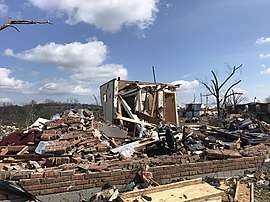
| EF4 tornado | |
|---|---|
 EF4 damage to homes along North McBroom Chapel Road just west of Cookeville | |
| Max. rating1 | EF4 tornado |
| Highest winds |
|
| Damage | $100 million (2020 USD) |
| Casualties | 19 fatalities, 87 injuries |
| 1Most severe tornado damage; see Enhanced Fujita scale | |
The supercell responsible for producing the Nashville tornado ascended the Highland Rim and produced another tornado just west of Ensor at 1:49 a.m. CST (07:49 UTC) on March 3. The tornado touched down along the north side of the concurrent US 70N and SR 24 and moved due-east, producing EF0 damage to trees, outbuildings, and homes as it approached SR 56 northwest of Baxter. The tornado reached EF1 intensity after crossing TN 56, passing through a residential subdivision. It caused minor to moderate roof damage to numerous homes and destroyed an outbuilding. The tornado intensified to EF2 strength as it crossed Prosperity Drive, tearing the roof and exterior walls off a home. Entering the community of Double Springs, the tornado heavily damaged or destroyed numerous homes and a garage structure at EF2 to EF3 strength, before cutting a narrow swath of intense damage across SR 291, Clemmons Road, Charlton Square, and Plunk Whitson Road. As the tornado crossed Charlton Square in the eastern part of the Eller Plantation subdivision, two homes were swept away. These homes were built on block foundations, but were fairly well-anchored, earning an EF4 rating. Maintaining EF4 strength along a 0.8-mile (1.3 km) swath, the tornado crossed Plunk Whitson Road and moved eastward through more residential areas.
Catastrophic damage was produced in this area as entire portions of neighborhoods were completely flattened. Numerous fatalities occurred 17 well-anchored block-foundation homes were leveled or swept away along Hensley Drive and North McBroom Chapel Road. Vehicles were thrown and severely damaged, and numerous trees were denuded and partially debarked in this area. Homes farther away from the center of the damage path sustained loss of roofs and exterior walls.[32]

Continuing eastward, the tornado continued to produce EF4 damage as it leveled a large apartment building along the north side of US 70N/SR 24. Just east of this point, additional EF4 damage occurred in the Echo Valley subdivision, where many homes were leveled or swept away. The tornado continued along US 70N/SR 24, weakening to high-end EF3 strength as it flattened the Echo Valley Market, a local convenience store. EF3-strength damage continued as it impacted residential areas within the vicinity of South Drive and Locust Grove Road, damaging or destroying multiple homes. A few poorly-anchored homes were leveled or swept from their foundations along this segment of the path, while a small apartment building, a metal structure, and outbuildings also sustained significant damage. Several metal storage unit buildings were destroyed in this area as well.[32]
The tornado weakened further to EF2 intensity as it crossed Tennessee Avenue and Miller Road, badly damaging a smoke shop and a metal-framed warehouse structure. Significant damage continued as the tornado moved due-east, following West Broad Street (US 70N/SR 24). Mobile homes and outbuildings were destroyed, and numerous frame homes were damaged, some of which sustained roof and exterior wall loss. A few businesses and other structures, including a bank and the Upper Cumberland Electric Membership Corporation, also sustained considerable damage as the tornado entered the Cookeville city limits.
A majority of the damage along this corridor was rated EF2, though a small pocket of low-end EF3 damage occurred near County Farm Road, where a poorly-anchored home was swept away. At the intersection of Pippin Road and West Jackson Street with West Broad Street, an Exxon gas station was severely damaged, and a used car dealership across the street was flattened, with only the basement of the building remaining. This damage was given a high-end EF2 rating. Continuing towards downtown Cookeville, the tornado passed south of Sycamore Elementary School, downing trees and causing minor to moderate damage to homes and other structures at EF0 to EF1 strength. Additional EF0 to EF1 damage to trees, some apartment buildings, and homes occurred as the tornado crossed Bucks Avenue and moved through areas just east of this point. The tornado then dissipated at Laurel Avenue and West 6th Street at 1:56 a.m. CST (07:56 UTC), just west of Cookeville Regional Medical Center and southwest of Tennessee Tech. The university remained closed for the two days following the storm. This tornado was given an EF4 rating, with maximum estimated winds of 175 mph (282 km/h). A total of 19 people were killed and 87 more were injured along the 8.39-mile (13.50 km) path.[34][32]
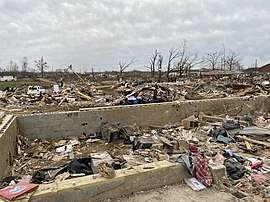
Non-tornadic impacts
The severe and tornadic thunderstorms across the region brought numerous other impacts aside from the tornadoes. In Kentucky, golf-ball sized hail fell in Paducah during the afternoon of March 2.[35] Later a microburst, with winds near 85 mph (137 km/h), caused major damage to a marina on Lake Barkley in Kuttawa. A dock had its metal flooring beams bent, while also sustaining damage to its many metal vertical supports and the metal roof, including a relatively small portion of it that was blown off. One boat was blown off a lift, and partially submerged as well and damage at the marina was estimated at $500,000 (2020 USD).[36] Flash flooding was also reported near the Hopkinsville Airport, where two cars were stranded, and Elkton due to the heavy rain.[37][38] Two roads in Coral Hill were also closed due to flowing water on the roadways.[39]
In Tennessee, the long-tracked Nashville supercell also bought baseball-to-lime-sized hail to Charolette, shattering windshields of numerous cars and causing roof damage to some homes, leading to $15,000 (2020 USD) in damage.[40] Later, after the Nashville EF3 tornado had lifted, a 4 miles (6.4 km) long swath of straight-line winds of up to 75 mph (121 km/h) affected Eastern Smith County north of Lancaster, with several trees being snapped or uprooted and a few outbuildings suffering roof damage. Damages here were estimated at $10,000 (2020 USD).[41]
Although spared from the worst impacts, Alabama also had their fair share of destructive weather the day after the outbreak on March 4. Severe thunderstorms bought destructive straight-line winds that downed numerous trees south of Interstate 85 across the southern part of the state. The highest wind gust was 59 mph (95 km/h) at the Troy Municipal Airport, which coincided with the many reports of downed trees around the city of Troy.[42]
Aftermath
.jpg)
Nashville Emergency Operations Center (EOC) was partially activated in the morning to monitor damage reports and respond to emergency calls.[43] A gas leak in Germantown made authorities conduct an evacuation.[44] Governor Bill Lee declared a state of emergency for all of Tennessee. President Donald Trump visited the state on March 6.[45] The Nashville Predators opened their home arena, Bridgestone Arena, for victims of the storm to get help and free pizza on March 3.[46]
Metro Nashville Public Schools, Wilson County Schools, and Putnam County Schools were closed for the rest of the week, with Mount Juliet Christian Academy, West Wilson Middle School and the adjacent Stoner Creek Elementary in Mount Juliet being heavily damaged and closed the remainder of the school year. Donelson Christian Academy was mostly destroyed as well.[47][48]
About 73,000 people across the state were left without power.[49] Interstate 40 was closed in both directions between Mount Juliet and Lebanon for 12 hours following the storm.[50]
Super Tuesday
The tornadoes struck a few hours before the voting was scheduled to open for the Tennessee Super Tuesday primary.[51] A delay of one hour was announced for the opening of polls in Davidson and Wilson counties; they were set to close on time.[51] Although many poll officials as well as polling sites were affected, the polling was scheduled to continue with adjustments. Two election commission offices in Davidson County were designated as "super sites" where anyone from the counties affected by the tornadoes could vote.[51] Generators were supplied to polling sites without power. Fifteen sites diverted voters to alternate locations.[52] On request from four of the democratic primary candidates, the Davidson County Superior Court judge issued a ruling extending voting in the county by an hour; five sites were set to open for voting until 10:00 p.m. CST.[53]
See also
- March 1933 Nashville tornado outbreak
- Tornado outbreak of April 15–16, 1998 - An outbreak that produced an F3 tornado in Nashville along a similar path to the 1933 and 2020 storms.
- 2008 Super Tuesday tornado outbreak - A similar tornado outbreak in Tennessee on Super Tuesday in 2008.
- 2011 Super Outbreak
- Tornado outbreak of March 2–3, 2012 - Also produced significant tornadoes in Kentucky and Tennessee on the same dates.
Notes
- All dates are based on the local time zone where the tornado touched down; however, all times are in Coordinated Universal Time for consistency.
References
- "NCDC Tornado Summaries". National Centers for Environmental Information. 2020. Retrieved June 26, 2020.
- Estes, Doug Stanglin, Ayrika L. Whitney and Gentry. "'Pretty much like an explosion': Day after brutal Nashville tornadoes that killed 25 people, 3 still missing". USA TODAY. Retrieved March 10, 2020.
- "Here's what to know about the tornadoes that killed 24 in Tennessee". WTVF. March 3, 2020. Retrieved March 10, 2020.
- Steve Goss; Nick Nauslar (March 4, 2020). "Mar 2, 2020 0600 UTC Day 1 Convective Outlook". Storm Prediction Center. Retrieved March 4, 2020.
- Rich Thompson; Ryan Jewell (March 4, 2020). "Mar 2, 2020 1300 UTC Day 1 Convective Outlook". Storm Prediction Center. Retrieved March 4, 2020.
- Roger Edwards (March 2, 2020). "Tornado Watch 35". Storm Prediction Center. Retrieved March 4, 2020.
- Brynn Kerr (March 2, 2020). "Mesoscale Discussion 136". Storm Prediction Center. Retrieved March 4, 2020.
- Brynn Kerr (March 2, 2020). "Mesoscale Discussion 137". Storm Prediction Center. Retrieved March 4, 2020.
- Brynn Kerr (March 2, 2020). "Mesoscale Discussion 138". Storm Prediction Center. Retrieved March 4, 2020.
- Roger Edwards (March 2, 2020). "Tornado Watch 36". Storm Prediction Center. Retrieved March 4, 2020.
- "Kentucky Event Report: EF1 Tornado". National Centers for Environmental Information. 2020. Retrieved June 26, 2020.
- "Tennessee Event Report: EF1 tornado". National Centers for Environmental Information. 2020. Retrieved June 26, 2020.
- Peake, Scott (March 2, 2020). "4 miles east-northeast of Malden". @ScottPeakeWX. Twitter. Retrieved March 3, 2020.
- "Missouri Event Report: EF0 Tornado". National Centers for Environmental Information. 2020. Retrieved June 26, 2020.
- "Tennessee Event Report: EF2 Tornado". National Centers for Environmental Information. 2020. Retrieved June 26, 2020.
- "Tennessee Event Report: EF2 Tornado". National Centers for Environmental Information. 2020. Retrieved June 26, 2020.
- "Tennessee Event Report: EF1 Tornado". National Centers for Environmental Information. 2020. Retrieved June 26, 2020.
- "Tennessee Event Report: EF0 Tornado". National Centers for Environmental Information. 2020. Retrieved June 26, 2020.
- "Kentucky Event Report: EF1 Tornado". National Centers for Environmental Information. 2020. Retrieved June 26, 2020.
- "Kentucky Event Report: EF1 Tornado". National Centers for Environmental Information. 2020. Retrieved June 26, 2020.
- "Tennessee Event Report: EF3 Tornado". National Centers for Environmental Information. 2020. Retrieved June 26, 2020.
- "Tennessee Event Report: EF3 Tornado". National Centers for Environmental Information. 2020. Retrieved June 26, 2020.
- "Tennessee Event Report: EF1 Tornado". National Centers for Environmental Information. 2020. Retrieved June 26, 2020.
- "Tennessee Event Report: EF0 Tornado". National Centers for Environmental Information. 2020. Retrieved June 26, 2020.
- "Tennessee Event Report: EF4 Tornado". National Centers for Environmental Information. 2020. Retrieved June 26, 2020.
- "Tennessee Event Report: EF0 Tornado". National Centers for Environmental Information. 2020. Retrieved June 26, 2020.
- "Tennessee Event Report: EF2 Tornado". National Centers for Environmental Information. 2020. Retrieved June 26, 2020.
- "Tennessee Event Report: EF0 Tornado". National Centers for Environmental Information. 2020. Retrieved June 26, 2020.
- "Alabama Event Report: EF0 Tornado". National Centers for Environmental Information. 2020. Retrieved June 26, 2020.
- "Alabama Event Report: EF1 Tornado". National Centers for Environmental Information. 2020. Retrieved June 26, 2020.
- Laken Bowles (March 4, 2020). "Tornado causes $93M worth of damage at John C. Tune Airport". WTVF. E. W. Scripps Company. Retrieved March 5, 2020.
- March 2-3, 2020 Tornadoes and Severe Weather (Report). National Oceanic and Atmospheric Administration. National Weather Service Weather Forecast Office in Nashville, Tennessee. March 5, 2020.
- Xavier Smith (March 4, 2020). "Fourth Wilson County tornado fatality found". Wilson Post. Retrieved March 7, 2020.
- https://apps.dat.noaa.gov/stormdamage/damageviewer/
- "Kentucky Event Report: 1.75 in. Hail". National Centers for Environmental Information. 2020. Retrieved June 26, 2020.
- "Kentucky Event Report: 74 kts. Thunderstorm Winds". National Centers for Environmental Information. 2020. Retrieved June 26, 2020.
- "Kentucky Event Report: Heavy Rain Flash Flood". National Centers for Environmental Information. 2020. Retrieved June 26, 2020.
- "Kentucky Event Report: Heavy Rain Flash Flood". National Centers for Environmental Information. 2020. Retrieved June 26, 2020.
- "Kentucky Event Report: Heavy Rain Flash Flood". National Centers for Environmental Information. 2020. Retrieved June 26, 2020.
- "Tennessee Event Report: 3.00 in. Hail". National Centers for Environmental Information. 2020. Retrieved June 26, 2020.
- "Tennessee Event Report: 65 kts. Thunderstorm Winds". National Centers for Environmental Information. 2020. Retrieved June 26, 2020.
- "Tennessee Event Report: 59 kts. Thunderstorm Winds". National Centers for Environmental Information. 2020. Retrieved June 26, 2020.
- "Tornado crosses through downtown Nashville; Widespread damage reported". WKRN. WKRN. Retrieved March 3, 2020.
- Brackett, Ron (March 3, 2020). "Tennessee Tornado Death Toll Jumps to 22; Widespread Damage in Nashville, Middle Tennessee". The Weather Channel. Retrieved March 3, 2020.
- Rojas, Rick (March 3, 2020). "Tennessee Tornado Live Updates: Nashville Hit and 22 Killed Across State". The New York Times. ISSN 0362-4331. Retrieved March 3, 2020.
- "Nashville Predators to open doors of Bridgestone Arena, feed people affected by area tornado". CBSSports.com. Retrieved March 4, 2020.
- 24 people are dead after a tornado ripped through Tennessee and destroyed numerous homes, Jason Hanna, Hollie Silverman and Chuck Johnston, CNN, March 3, 2020
- "'Unbelievable damage' in Donelson after tornado passes through Middle Tennessee". WTVF. March 3, 2020. Retrieved March 3, 2020.
- "Nashville tornado live updates: 9 dead as twister rips through city and suburbs". ABC News. ABC News. Retrieved March 3, 2020.
- Producer, Ethan Illers, Digital Content. "I-40 closed in both directions between Mount Juliet and Lebanon". WSMV Nashville. Retrieved March 3, 2020.
- Gee, Brandon; Bella, Timothy; Bellware, Kim; Cappucci, Matthew; Kornfield, Meryl. "Tornadoes kill at least 19 people, leave trail of destruction in and around Nashville". Washington Post. Retrieved March 3, 2020.
- "Deadly overnight tornadoes disrupt voting in Tennessee". POLITICO. Retrieved March 4, 2020.
- "Tornadoes kill at least 25 in Tennessee on Super Tuesday, crews search for missing". Reuters. March 4, 2020. Retrieved March 4, 2020.