Wheatfield, New York
Wheatfield is a town in Niagara County, New York, United States. The population was 18,117 at the 2010 census. The name stems from the agricultural use of the town lands, the growing of wheat.
Wheatfield, New York | |
|---|---|
Town | |
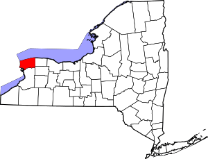
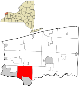 Location in Niagara County and the state of New York. | |
 Wheatfield, New York Location in Niagara County and the state of New York. | |
| Coordinates: 43°5′32″N 78°53′42″W | |
| Country | United States |
| State | New York |
| County | Niagara |
| Government | |
| • Type | Town Council |
| • Town Supervisor | Don MacSwan (R) |
| • Town Council | Members' List
|
| Area | |
| • Total | 28.59 sq mi (74.05 km2) |
| • Land | 27.91 sq mi (72.27 km2) |
| • Water | 0.69 sq mi (1.78 km2) |
| Elevation | 577 ft (176 m) |
| Population (2010) | |
| • Total | 18,117 |
| • Estimate (2016)[2] | 18,284 |
| • Density | 655.22/sq mi (252.99/km2) |
| Time zone | UTC-5 (Eastern (EST)) |
| • Summer (DST) | UTC-4 (EDT) |
| ZIP codes | 14120, 14304, 14132 |
| Area code(s) | 716 |
| FIPS code | 36-81380[3] |
| GNIS feature ID | 0979632[4] |
The Town of Wheatfield is east of Niagara Falls International Airport.
History
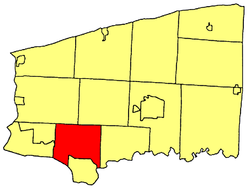
The Town of Wheatfield was formed in 1836 from the Town of Niagara. It is situated in the southwest part of the county, surrounded by the Towns of Lewiston and Cambria to the north, Pendleton to the east, the City of North Tonawanda and the Niagara River to the south, and the City of Niagara Falls and Town of Niagara to the west.
The first town meeting was held on June 6, 1836, in the schoolhouse of District No. 7, on the north line of the Town. The soil of the town, clay loam, is very good for wheat crops in particular, and leads to the origin of the name Wheatfield.
Starting in 1843, German immigrants in the region established the communities of Bergholz, St. Johnsburg, Walmore, Martinsville, and Gratwick. (The latter two towns are now part of North Tonawanda.) Later, other communities were formed at railroad stops and along major highways.
In the 1920s, the River Road section of the Town became a prosperous farm area, including the showplace "Wheatfield Farms". Vacation cottages, beaches, an amusement park, and nightclubs were all constructed along the river. Permanent housing has since replaced most of these, but some remnants are still visible along River Road.
During World War II, industries located in the Town. The largest was Bell AeroSpace Company which produced the World War II fighter plane, P-39 Airacobra, and later, products for the aerospace industry. During the postwar period, other small industries and businesses were established in the Town, especially those serving the tourist trade such as motels and restaurants.
Growth and prosperity in the Town continued as families migrated from nearby communities creating new neighborhoods. During this period, Summit Park Mall was built and opened in 1972 to serve the people of Wheatfield and nearby communities.
The largest spurt of growth in the Town began in the 1980s and still continues today with many new housing developments emerging and new industrial and business parks being built. The population of the Town now exceeds 13,000, which classifies it as a town of the first class. Even with the growth of the Town, farming is still carried on with dairy farming being our main enterprise.
Probably the earliest settler on the site of North Tonawanda was George N. Burger, who came in 1809, built a log tavern on the river, and remained a resident until about 1825. Joshua Pettit came in 1810 and settled near the Niagara Iron Works, where he opened a tavern. He was the father of Mrs. Daniel C. Jacobs and Mrs. Whitman Jacobs. Stephen Jacobs, a soldier at the battle of Bunker Hill, located on the river two miles (3 km) below in 1817, where he purchased 196 acres (0.79 km2) of Augustus Porter, paying eight dollars an acre. He died in Niagara Falls in January, 1840. William Vandervoorte settled here in 1825, occupying a log house which tradition says was the only one then in existence. It was his intention to make a business of purchasing staves and timber for the Boston market, and ultimately to open a mercantile business. In 1828 he finished the first public house in the place, which was called the Niagara; it was burned in 1844. Later he purchased 1,000 acres (4.0 km2) of land of the Holland Company and sold to Prussian immigrants the largest part of their possessions on Tonawanda Creek and its vicinity. He established the first bank in 1836. As before indicated, little progress of a business nature was made here until the opening of the Erie Canal. The interior of the town was still almost an unbroken wilderness and as late as 1850 a large part of the area of the town was unimproved.
Geography
According to the United States Census Bureau, the town has a total area of 28.6 square miles (74 km2), of which 27.9 square miles (72 km2) is land and 0.7 square miles (1.8 km2) 2.41% is water.
The Niagara River is part of the western border of the town.
Adjacent cities and towns
- City of North Tonawanda - south
- City of Niagara Falls - west
- Town of Niagara - west
- Town of Lewiston - northwest
- Town of Cambria - northeast
- Town of Pendleton - east
- Erie County, Town of Amherst - southeast
- Erie County, Town of Grand Island - southwest
Major highways in the Town of Wheatfield


Demographics
| Historical population | |||
|---|---|---|---|
| Census | Pop. | %± | |
| 1840 | 1,057 | — | |
| 1850 | 2,659 | 151.6% | |
| 1860 | 3,484 | 31.0% | |
| 1870 | 3,406 | −2.2% | |
| 1880 | 4,390 | 28.9% | |
| 1890 | 4,015 | −8.5% | |
| 1900 | 1,926 | −52.0% | |
| 1910 | 1,792 | −7.0% | |
| 1920 | 1,884 | 5.1% | |
| 1930 | 2,212 | 17.4% | |
| 1940 | 3,077 | 39.1% | |
| 1950 | 4,720 | 53.4% | |
| 1960 | 8,008 | 69.7% | |
| 1970 | 9,722 | 21.4% | |
| 1980 | 9,609 | −1.2% | |
| 1990 | 11,125 | 15.8% | |
| 2000 | 14,086 | 26.6% | |
| 2010 | 18,117 | 28.6% | |
| Est. 2016 | 18,284 | [2] | 0.9% |
| U.S. Decennial Census[5] | |||
Wheatfield is within the Buffalo–Niagara Falls metropolitan area. As of the 2010 United States Census, the town's current population is 18,117.
As of the census[3] of 2000, there were 14,086 people, 5,305 households, and 3,893 families residing in the town. The population density was 504.6 people per square mile (194.9/km²). There were 5,555 housing units at an average density of 199.0 per square mile (76.8/km²). The racial makeup of the town was 97.44% White, 0.99% African American, 0.43% Native American, 0.49% Asian, 0.04% Pacific Islander, 0.08% from other races, and 0.55% from two or more races. Hispanic or Latino of any race were 0.58% of the population.
There were 5,305 households out of which 32.3% had children under the age of 18 living with them, 63.6% were married couples living together, 6.7% had a female householder with no husband present, and 26.6% were non-families. 22.6% of all households were made up of individuals and 10.6% had someone living alone who was 65 years of age or older. The average household size was 2.58 and the average family size was 3.04.
In the town, the population was spread out with 23.5% under the age of 18, 6.4% from 18 to 24, 29.1% from 25 to 44, 25.2% from 45 to 64, and 15.8% who were 65 years of age or older. The median age was 40 years. For every 100 females, there were 93.0 males. For every 100 females age 18 and over, there were 90.3 males.
The median income for a household in the town was $51,700, and the median income for a family was $61,315. Males had a median income of $42,076 versus $27,233 for females. The per capita income for the town was $22,184. About 2.5% of families and 4.2% of the population were below the poverty line, including 3.5% of those under age 18 and 5.9% of those age 65 or over.
Public safety
The Town of Wheatfield has five volunteer fire companies. Those five departs are; Adams Fire Company, Bergholz Volunteer Fire Company, Frontier Volunteer Fire Company, Shawnee Volunteer Fire Company, and St. Johnsburg Fire Company.
The Town has a volunteer Ambulance corp, called Tri-Community Ambulance Service. Tri-Community ambulance Service was established in 1956, and has three Advanced Life Support ambulances and one Advanced Life Support Rapid Response Vehicle.
The Town of Wheatfield has a Constable Department whose members are sworn Peace Officers under Article 2.10 of the NYS Criminal Procedure Law.
Education
There are six public schools and four private schools in Wheatfield, including St. Peter's Lutheran Church and School.
Notable people
- John Wayne Bobbitt, graduated from Niagara Wheatfield Senior High School in 1985.
- Adam Clendening, NHL hockey player, Although born in Niagara Falls, New York Clendening was raised in Wheatfield.
- Lewis S. Payne, former New York State Senator.
Communities and locations in Wheatfield
- Bergholz – A hamlet in the northwestern part of the town near the airport.
- Hoffman – A location on the eastern border of the town.
- Nashville – A location on US-62 in the southeast part of the town.
- Niagara Falls International Airport (IAG) – Part of the airport is in the northern part of the town.
- Sawyer – A hamlet on US-62 adjacent to the City of North Tonawanda.
- Shawnee – A hamlet on US-62 (Niagara Falls Boulevard).
- St. Johnsburg – A hamlet on US-62 near the center of the town.
- Walmore – A hamlet in the northwest part of the town on Lockport Road.
References
- "2016 U.S. Gazetteer Files". United States Census Bureau. Retrieved Jul 5, 2017.
- "Population and Housing Unit Estimates". Retrieved June 9, 2017.
- "U.S. Census website". United States Census Bureau. Retrieved 2008-01-31.
- "US Board on Geographic Names". United States Geological Survey. 2007-10-25. Retrieved 2008-01-31.
- "Census of Population and Housing". Census.gov. Retrieved June 4, 2015.
External links
Places adjacent to Wheatfield, New York | ||||||||||
|---|---|---|---|---|---|---|---|---|---|---|
| ||||||||||