Tha Ruea District
Tha Ruea (Thai: ท่าเรือ, pronounced [tʰâː rɯ̄a̯]) is a district (amphoe) in northeastern part of Ayutthaya Province, central Thailand.
Tha Ruea ท่าเรือ | |
|---|---|
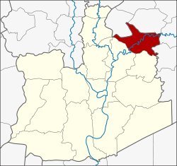 District location in Ayutthaya Province | |
| Coordinates: 14°33′6″N 100°43′39″E | |
| Country | Thailand |
| Province | Ayutthaya |
| Seat | Tha Chao Sanook |
| Tambon | 10 |
| Muban | 84 |
| Area | |
| • Total | 106.2 km2 (41.0 sq mi) |
| Population (2018) | |
| • Total | 46,925[1] |
| • Density | 441.9/km2 (1,145/sq mi) |
| Time zone | UTC+7 (ICT) |
| Postal code | 13130 |
| Geocode | 1402 |
History
The original name of the district was Nakhon Noi.[2]In 1917, it was renamed Tha Ruea to commemorate an important event within the district. When the hunter Bun found the Buddha's footprint in Sara Buri Province, King Songtham travelled by royal barge along the Pa Sak River to worship. He moored his royal barge in the district, and continued his travel overland. His route has since become a royal tradition, as later kings always travelled by this way to worship Buddha's footprint in Wat Phra Phutthabat. The Thai word "tha ruea" means "port" or "pier".
Geography
Neighboring districts are (from the north clockwise) Don Phut, Ban Mo, Sao Hai, Nong Saeng of Saraburi Province, and Phachi and Nakhon Luang of Ayutthaya Province.
Administration
Provincial government
The district is divided into 10 subdistricts (tambons), which are further subdivided into 84 villages (mubans).[1]
| # | Name | Thai | Vil. | Pop. |
|---|---|---|---|---|
| 1 | Tha Ruea | ท่าเรือ | - | 6,768 |
| 2 | Champa | จำปา | 9 | 8,760 |
| 3 | Tha Luang | ท่าหลวง | 10 | 5,856 |
| 4 | Ban Rom | บ้านร่อม | 9 | 3,073 |
| 5 | Sala Loi | ศาลาลอย | 15 | 4,794 |
| 6 | Wang Daeng | วังแดง | 8 | 3,185 |
| 7 | Pho En | โพธิ์เอน | 6 | 3,143 |
| 8 | Pak Tha | ปากท่า | 8 | 2,882 |
| 9 | Nong Khanak | หนองขนาก | 10 | 4,561 |
| 10 | Tha Chao Sanook | ท่าเจ้าสนุก | 9 | 3,903 |
| Total: | 84 | 46,925 |
Local government
As of 31 December 2018 there are two subdistrict municipalities (thesaban tambon) in the district. The non-municipal areas are administered by nine Subdistrict Administrative Organizations - SAO (ongkan borihan suan tambon).[1]
| 1 | Tha Luang subdistrict municipality | Pop. |
| Subdistrict Champa | 5,873 | |
| Subdistrict Tha Luang | 2,900 | |
| Total population | 8,773 | |
| 2 | Tha Ruea subdistrict municipality | 6,768 |
| # | Name | Thai | Pop. |
|---|---|---|---|
| 1 | Champa SAO | จำปา | 2,887 |
| 2 | Tha Luang SAO | ท่าหลวง | 2,956 |
| 3 | Ban Rom SAO | บ้านร่อม | 3,073 |
| 4 | Sala Loi SAO | ศาลาลอย | 4,794 |
| 5 | Wang Daeng SAO | วังแดง | 3,185 |
| 6 | Pho En SAO | โพธิ์เอน | 3,143 |
| 7 | Pak Tha SAO | ปากท่า | 2,882 |
| 8 | Nong Khanak SAO | หนองขนาก | 4,561 |
| 9 | Tha Chao Sanook SAO | ท่าเจ้าสนุก | 3,903 |
| Total: | 31,384 |
References
- "ร่ยงานสถิติจำนวนประชากรและบ้านประจำปี พ.ศ.2561" [Statistics, population and house statistics for the year 2018]. Registration Office Department of the Interior, Ministry of the Interior. stat.bora.dopa.go.th (in Thai). 31 December 2018. Retrieved 20 June 2019.
- "ประกาศเรึ่องเปลียนชืออำเภอ" [Notification of the name change of the district] (PDF). Royal Thai Government Gazette. 34 (Episode 0): 40–41. 29 April 1917. Retrieved 5 November 2019.