Phra Nakhon Si Ayutthaya District
Phra Nakhon Si Ayutthaya (Thai: พระนครศรีอยุธยา, pronounced [pʰráʔ ná(ʔ).kʰɔ̄ːn sǐː ʔā.jút.tʰā.jāː]) is the capital district (amphoe Mueang) of Phra Nakhon Si Ayutthaya Province, central Thailand. Its former name as the capital city of Ayutthaya Kingdom was "Krungthep Thawarawadi Si Ayutthaya" (Thai: กรุงเทพทวารวดีศรีอยุธยา).
Phra Nakhon Si Ayutthaya พระนครศรีอยุธยา | |
|---|---|
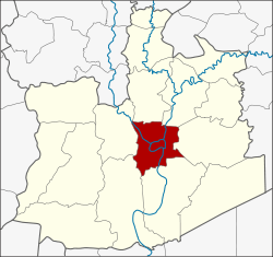 District location in Ayutthaya Province | |
| Coordinates: 14°21′8″N 100°34′36″E | |
| Country | Thailand |
| Province | Ayutthaya |
| Seat | Ho Rattanachai |
| Area | |
| • Total | 130.6 km2 (50.4 sq mi) |
| Population (2006) | |
| • Total | 136,467 |
| • Density | 1,053.13/km2 (2,727.6/sq mi) |
| Time zone | UTC+7 (ICT) |
| Postal code | 13000 |
| Geocode | 1401 |
History
According to George Coedes, tradition states Ramathibodi I founded Dvaravati Sri Ayudhya in 1350.[1]:222
Created in 1897, the district was originally called Rop Krung (รอบกรุง). The district name was changed to Krung Kao (กรุงเก่า) in 1917.[2] In 1957 the name was changed to Phra Nakhon Si Ayutthaya.[3] to commemorate the old capital city of the Ayutthaya Kingdom. This makes it unique among Thailand's capital districts, the rest of which are named amphoe mueang followed by the name of province.
Geography
Neighboring districts are (from the north clockwise) Bang Pahan, Nakhon Luang, Uthai, Bang Pa-in, Bang Sai and Bang Ban.
Administration
The district is divided into 21 sub-districts (tambon). In addition to the city (thesaban nakhon) of Ayutthaya there are other municipal areas. Ayothaya is a town (thesaban mueang) which covers part of the tambons Phai Ling, Hantra, and Khlong Suan Phlu.
| No. | Name | Thai | Pop. |
|---|---|---|---|
| 1. | Pratu Chai | ประตูชัย | 16,155 |
| 2. | Kamang | กะมัง | 1,458 |
| 3. | Ho Rattanachai | หอรัตนไชย | 11,671 |
| 4. | Hua Ro | หัวรอ | 12,427 |
| 5. | Tha Wasukri | ท่าวาสุกรี | 8,756 |
| 6. | Phai Ling | ไผ่ลิง | 15,232 |
| 7. | Pak Kran | ปากกราน | 5,526 |
| 8. | Phukhao Thong | ภูเขาทอง | 2,748 |
| 9. | Samphao Lom | สำเภาล่ม | 6,368 |
| 10. | Suan Phrik | สวนพริก | 3,941 |
| 11. | Khlong Takhian | คลองตะเคียน | 4,798 |
| 12. | Wat Tum | วัดตูม | 4,219 |
| 13. | Hantra | หันตรา | 7,261 |
| 14. | Lumphli | ลุมพลี | 5,083 |
| 15. | Ban Mai | บ้านใหม่ | 4,415 |
| 16. | Ban Ko | บ้านเกาะ | 4,892 |
| 17. | Khlong Suan Phlu | คลองสวนพลู | 6,605 |
| 18. | Khlong Sa Bua | คลองสระบัว | 4,380 |
| 19. | Ko Rian | เกาะเรียน | 2,619 |
| 20. | Ban Pom | บ้านป้อม | 6,504 |
| 21. | Ban Run | บ้านรุน | 1,409 |
References
- Coedès, George (1968). Walter F. Vella (ed.). The Indianized States of Southeast Asia. trans.Susan Brown Cowing. University of Hawaii Press. ISBN 978-0-8248-0368-1.
- ประกาศกระทรวงมหาดไทย เรื่อง เปลี่ยนชื่ออำเภอ (PDF). Royal Gazette (in Thai). 34 (0 ก): 40–68. April 29, 1917., corrected with แก้คำผิด ราชกิจจานุเบกษา แผนกกฤษฎีกา เล่ม ๓๔ ตอนที่ ๕ ประกาศกระทรวงมหาดไทย เรื่อง เปลี่ยนชื่ออำเภอ หน้า ๔๑,๔๒ (PDF). Royal Gazette (in Thai). 34 (0 ง): 386. May 6, 1917.
- พระราชกฤษฎีกาเปลี่ยนชื่ออำเภอกรุงเก่า พ.ศ. ๒๕๐๐ (PDF). Royal Gazette (in Thai). 74 (25 ก): 546. March 5, 1957.
| Wikimedia Commons has media related to Phra Nakhon Si Ayutthaya District. |