Sena District
Sena (Thai: เสนา, pronounced [sěːnāː]) is a district (amphoe) in Ayutthaya Province, central Thailand. Local people typically know Sena as Ban Phaen (บ้านแพน).
Sena เสนา | |
|---|---|
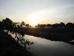 Khlong in Chao Chet | |
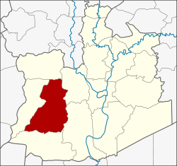 District location in Ayutthaya Province | |
| Coordinates: 14°19′38″N 100°24′16″E | |
| Country | Thailand |
| Province | Ayutthaya |
| Seat | Sena |
| Tambon | 17 |
| Muban | 132 |
| Area | |
| • Total | 205.6 km2 (79.4 sq mi) |
| Population (2012) | |
| • Total | 66,670 |
| • Density | 313.4/km2 (812/sq mi) |
| Time zone | UTC+7 (ICT) |
| Postal code | 13110 |
| Geocode | 1412 |
Geography
Neighboring districts are (from the north clockwise) Phak Hai, Bang Ban, Bang Sai (บางไทร), Lat Bua Luang and Bang Sai (บางซ้าย) of Ayutthaya Province.
Administration
The district is divided into 17 sub-districts (tambon), which are further subdivided into 132 administrative villages (muban). Sena is a town covering the whole Sena sub-district. There are four sub-district municipalities (thesaban tambon) − Sam Ko and Bang Nom Kho cover the whole same-named sub-district, Hua Wiang the whole sub-district Hua Wiang and Ban Krathum, and Chao Chet the whole sub-district Chao Sadet and parts of the sub-district Chao Chet and Ban Thaeo. There are a further nine tambon administrative organizations as the local government for the sub-districts not part of a municipality.
| No. | Name | Thai | Pop.[1] |
|---|---|---|---|
| 1. | Sena | เสนา | 4,103 |
| 2. | Ban Phaen | บ้านแพน | 3,370 |
| 3. | Chao Chet | เจ้าเจ็ด | 4,729 |
| 4. | Sam Ko | สามกอ | 7,003 |
| 5. | Bang Nom Kho | บางนมโค | 7,127 |
| 6. | Hua Wiang | หัวเวียง | 4,236 |
| 7. | Manwichai | มารวิชัย | 2,556 |
| 8. | Ban Pho | บ้านโพธิ์ | 3,456 |
| 9. | Rang Chorakhe | รางจรเข้ | 2,753 |
| 10. | Ban Krathum | บ้านกระทุ่ม | 2,122 |
| 11. | Ban Thaeo | บ้านแถว | 4,084 |
| 12. | Chai Na | ชายนา | 4,880 |
| 13. | Sam Tum | สามตุ่ม | 4,692 |
| 14. | Lat Nga | ลาดงา | 3,437 |
| 15. | Don Thong | ดอนทอง | 2,444 |
| 16. | Ban Luang | บ้านหลวง | 2,844 |
| 17. | Chao Sadet | เจ้าเสด็จ | 2,834 |
References
- "Population statistics 2012". Department of Provincial Administration.