Te Henga (Bethells Beach)
Te Henga (Bethells Beach) is a coastal community of the Auckland Region in the north of the North Island, New Zealand. The Māori name for the area "Te Henga" is in reference to the long foredunes which run along the beach and look like the "Henga" or "Gunwhale" of an upturned waka hull.[1] This name originally applied to a wide area of the lower Waitakere River valley, but during the early 1900s the area became popular with visiting European immigrants who began to refer to the area as "Bethells Beach" after the Bethells Family who live there and still own much of the area. In 1976 the New Zealand Geographic Board officially named the area "Te Henga (Bethells Beach)".[2]
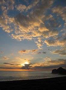
The beach is approximately 37 kilometres west of Auckland City, at the mouth of the Waitakere River where it flows into the Tasman Sea. One of several popular resorts in the area (others include Muriwai, Piha and Karekare), it is rated the 4th most dangerous beach in New Zealand to swim at due to its strong rips and currents. There have been many fatalaties including in 2009, Rugby League star Sonny Fai who was never located. It experiences a population explosion over summer with thousands of visitors. This has put a lot of pressure on the local infrastructure and environment with an increase in rubbish and parking issues.
History and culture
The Te Henga Valley shows evidence of human settlement dating back many centuries. The cultural history of the area is of archaeologically significant sites, including food gathering areas, pā (fortifications), walkways, canoe landings and sacred places.[2]
The area was a major settlement and community centre for the local iwi (tribe) Te Kawerau a Maki. In the mid 1800s much of the area (1180 hectares) was designated as the Waitakere and Puketotara Native Reserve. These native reserves were to be ‘inalienable’ for Kawerau people to live on in perpetuity. The provision of the native reserves was largely undermined by the Native Land Court, created in 1865, which was based on the settlers' legal system, and converted customary title to land into individual title. Over the following decades much of the land was sold to European immigrants.[1]
The arrival of Europeans in the 19th century led to major changes in the character and shape of Te Henga (Bethells Beach). The most significant of these changes was the clearing of the land for timber and pastoral farming which began in 1854 and continued until the 1920s. In addition, a dam was constructed on the Waitakere River in the 1920s, drastically altering the level of the riverbed and reducing the outflow of water to the sea.[2]
John Bethell negotiated with the Waitakere County Council to sell the land that is now known as Te Henga Park. The Council considered the beach and park area would provide excellent recreation facilities for residents of Auckland. Te Henga was recognised as a place of regional significance.[2]
Demographics
| Historical population | ||
|---|---|---|
| Year | Pop. | ±% p.a. |
| 2006 | 825 | — |
| 2013 | 945 | +1.96% |
| 2018 | 1,104 | +3.16% |
| Source: [3] | ||
The statistical area of Muriwai Valley-Bethells Beach, which at 35 square kilometres is larger than this community, had a population of 1,104 at the 2018 New Zealand census, an increase of 159 people (16.8%) since the 2013 census, and an increase of 279 people (33.8%) since the 2006 census. There were 372 households. There were 564 males and 540 females, giving a sex ratio of 1.04 males per female. The median age was 39.2 years, with 237 people (21.5%) aged under 15 years, 177 (16.0%) aged 15 to 29, 570 (51.6%) aged 30 to 64, and 120 (10.9%) aged 65 or older.
Ethnicities were 96.5% European/Pākehā, 10.1% Māori, 3.0% Pacific peoples, 1.6% Asian, and 1.4% other ethnicities (totals add to more than 100% since people could identify with multiple ethnicities).
The proportion of people born overseas was 20.4%, compared with 27.1% nationally.
Although some people objected to giving their religion, 67.1% had no religion, 23.4% were Christian, and 3.0% had other religions.
Of those at least 15 years old, 246 (28.4%) people had a bachelor or higher degree, and 90 (10.4%) people had no formal qualifications. The median income was $38,600. The employment status of those at least 15 was that 489 (56.4%) people were employed full-time, 168 (19.4%) were part-time, and 27 (3.1%) were unemployed.[3]
Marae
Te Henga is a tribal meeting ground for the local iwi of Te Kawerau a Maki.[4][5] Historically there were several marae spread around the Te Henga (Bethells Beach) area, however these sites are now all in private ownership and housing. Currently the iwi are in negotiations with Auckland Council to set up a new marae at Te Henga so they can return to their ancestral heartland.
Geology
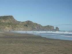
The sand dunes have accumulated in several phases over the last 4,500 years. This accumulation has occurred since sea levels returned to about their present levels following the last glaciation 6,500 years ago. These sands contain quantities of black titanomagnetite derived from the volcanic rocks of Taranaki and carried north by coastal currents. The dunes continually move in a dynamic coastal process. There are three dune-impounded lakes: Lake Wainamu, Lake Kawaupaku and Lake Waiataru.
Ecology of the Waitakere River catchment
The Waitakere River catchment consists of roughly 70 km² of the bush-clad Waitākere Ranges. Located on the west coast of the Auckland Region approximately 75% of the catchment consists of native vegetation in spite of extensive milling, farming and settlement.
The major features of the catchment are:
- the abundance of native vegetation
- the steep and rugged terrain
- the Te Henga wetland
- the sand dunes
- Lake Wainamu
- The Waitākere Reservoir
The Waitakere River has two main tributaries, the Mokoroa and Waiti streams. The headwaters of the river are in the vast and steep Waitākere Ranges and drain out at the Bethell's Beach river mouth.
In comparison with other North Island beaches, and to some extent even the west coast beaches of Muriwai and Piha, settlement at Bethells has been minor with most development revolving around horticulture and agriculture.
With the exception of the Waitākere Reservoir the catchments resources have largely escaped development.
In 1990 The Auckland Regional Water Board developed and prepared a Waitakere River Catchment Water and Soil Plan. This pre-Resource Management Act document aimed to deal with the competing water and soil resource demands within the catchment in terms of "conservation, allocation, use and quality of natural water and in terms of soil conservation and preventing damage from flooding." Although this document reached its quarter-century in 2015 many of its principles still apply.
Lake Wainamu is a dune lake that formed during the last 6,500 years when the Wainamu Stream Valley was dammed by dunes of sand blown inland. A decline in water quality was noted in 1990s and was thought to be caused by exotic fish accelerating the loss of the submerged plant life. In response the Auckland Regional Council removed over 9,000 exotic fish (particularly perch, goldfish and rudd) between 2004 and 2007.[6] In 2009, grass carp were introduced to the lake in an attempt to rid it of introduced egeria.[7] The lake is also home to native freshwater fish including banded kokopu, inanga, common smelt, common bully, grey mullet, longfin and short-finned eel.[6]
Activity
- Surfing is the main pastime. Other pastimes include parasailing and hang gliding, for which the prevailing westerly wind often provides favourable conditions.
- Fishing is also popular, although dangerous in many places and many deaths have taken place from this.
- Bush walking is encouraged, with boardwalks in place.
- Sunbathing, swimming, picnics, running etc.
- Skimboarding is also becoming quite popular with young people.
Filming location
The beach has been used as a filming location for several projects, one of the earliest being a four-month shoot for award-winning drama series Children of Fire Mountain (1979). Other shoots include the music video for Shania Twain single "Forever and for Always"(2003), "Out of the Woods" for Taylor Swift, TV series The New Adventures of Black Beauty, Brit/New Zealand TV movie The Man Who Lost His Head, and episodes of Xena: Warrior Princess, Young Hercules, and Hercules: The Legendary Journeys. Battle scenes for New Disney Channel Original movie Avalon High were also filmed there. In addition, K-pop singer Taeyeon's first solo music video I, and the end scenes of Crouching Tiger Hidden Dragon: Sword of Destiny were also filmed here.
Gallery
 Fun in the lagoon
 Bethell patterns
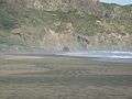 Cave
Cave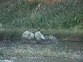 Shag
Shag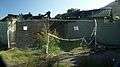 Burnt ablutions block
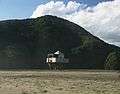 Surf lifesaving lookout
References
- TKITA-2013-0062 Cultural Values Assessment for Te Henga Local Area Plan, prepared by Te Kawerau Iwi Tribal Authority
- "Te Henga Park Reserve Management Plan: Description of Te Henga Park" (PDF). Waitakere City. June 2002. Archived from the original (PDF) on 24 July 2011.
- "Statistical area 1 dataset for 2018 Census". Statistics New Zealand. March 2020. Muriwai Valley-Bethells Beach (115300). 2018 Census place summary: Muriwai Valley-Bethells Beach
- "Te Kāhui Māngai directory". tkm.govt.nz. Te Puni Kōkiri.
- "Māori Maps". maorimaps.com. Te Potiki National Trust.
- "Lake Wainamu. Auckland Regional Council. Accessed 30 March 2009.
- "Army of fish to battle nasty weed". 24 March 2009. Auckland Regional Council. Accessed 30 March 2009.