Tanga Region
Tanga Region is one of the 31 administrative regions of Tanzania. It is bordered by Kenya and Kilimanjaro Region to the north; Manyara Region to the west; and Morogoro and Pwani regions to the south. Its eastern border is formed by the Indian Ocean. It has a population of about two million.
Tanga Region Mkoa wa Tanga (Swahili) | |
|---|---|
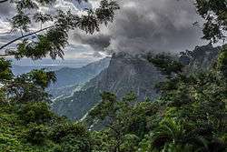 The western Usambara Mountains | |
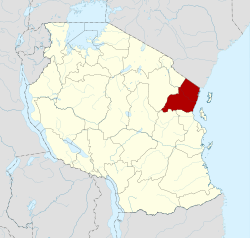 Location in Tanzania | |
| Country | Tanzania |
| Zone | Northern |
| Capital | Tanga |
| Districts | |
| Government | |
| • Regional Commissioner | Martin Shigela |
| Area | |
| • Total | 26,677 km2 (10,300 sq mi) |
| Population (2012) | |
| • Total | 2,045,205 |
| • Density | 77/km2 (200/sq mi) |
| Time zone | UTC+3 (EAT) |
| Postcode | 21xxx |
| Area code(s) | 027 |
| HDI (2018) | 0.547[1] low · 8th of 25 |
| Website | www |
History
The region was previously known as Tanga Province and included Same and Mwanga districts that are at present in Kilimanjaro Region.
Districts
The region is administratively divided into ten districts:[2]
| Districts of Tanga Region | ||||||||||||
|---|---|---|---|---|---|---|---|---|---|---|---|---|
| Map | District | Population | ||||||||||
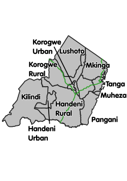 |
Handeni Rural | 276,646 | ||||||||||
| Handeni Urban | 79,056 | |||||||||||
| Kilindi | 236,833 | |||||||||||
| Korogwe Rural | 242,038 | |||||||||||
| Korogwe Urban | 68,308 | |||||||||||
| Lushoto | 492,441 | |||||||||||
| Muheza | 204,461 | |||||||||||
| Mkinga | 118,065 | |||||||||||
| Pangani | 54,025 | |||||||||||
| Tanga | 273,332 | |||||||||||
| Total | 2,045,205 | |||||||||||
Demographics
As per the 2012 census, it has a population of 2,045,205[3] The tribes that have migrated to the region are the Pare, Wataita, Wasambaa, Wambugu, Segeju, Wadigo, Wanago and Wazigua.
References
- "Sub-national HDI - Area Database - Global Data Lab". hdi.globaldatalab.org. Retrieved 2020-02-26.
- "Tanga Region - Councils". Tanga Region. Retrieved 3 August 2019.
- "Population Distribution by Administrative Units, United Republic of Tanzania, 2013" (PDF). National Bureau of Statistics, Ministry of Finance, Dar es Salaam and Office of Chief Government Statistician, President’s Office, Zanzibar. March 2013. Archived from the original (PDF) on June 12, 2013.
This article is issued from Wikipedia. The text is licensed under Creative Commons - Attribution - Sharealike. Additional terms may apply for the media files.