Kilindi District
Kilindi is one of the ten districts of Tanga Region in Tanzania. It is bordered to the east by the Handeni District and Handeni Town Council, to the north and west by the Kilimanjaro Region and to the south by the Morogoro Region. It split from Handeni District in 2002.
Kilindi District Wilaya ya Kilindi (Swahili) | |
|---|---|
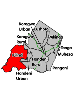 Location within Tanga Region (red) | |
| Country | Tanzania |
| Zone | Northern |
| Region | Tanga |
| Incorporated District | 2002 |
| Government | |
| • District Commissioner | Sauda Salumu Mtondoo |
| Area | |
| • Total | 6,443.52 km2 (2,487.86 sq mi) |
| Population (2012) | |
| • Total | 236,833 |
| • Density | 37/km2 (95/sq mi) |
| Time zone | UTC+3 (EAT) |
| Postcode | 219xx |
| Area code(s) | 027 |
| Website | www |
Administrative subdivisions
As of 2012, Kilindi District was administratively divided into 21 wards.[1]
Wards
- Jaila
- Kibirashi
- Kikunde
- Kilindi
- Kilwa
- Kimbe
- Kisangasa
- Kwediboma
- Kwekivu
- Lwande
- Mabalanga
- Masagalu
- Mkindi
- Msanja
- Mafisa
- Bokwa
- Negero
- Pagwi
- Saunyi
- Songe
- Tunguli
References
- "2012 Population and Housing Census" (PDF). Development Partners Group Tanzania. Retrieved 7 August 2019.
This article is issued from Wikipedia. The text is licensed under Creative Commons - Attribution - Sharealike. Additional terms may apply for the media files.