Mara Region
Mara Region is one of Tanzania's 31 administrative regions. The regional capital is the municipality of Musoma. According to the 2012 national census, the region had a population of 1,743,830, which was lower than the pre-census projection of 1,963,460.[2]:page 2 For 2002–2012, the region's 2.5 percent average annual population growth rate was the thirteenth highest in the country.[2]:page 4 It was also the twelfth most densely populated region with 80 people per square kilometer.[2]:page 6
Mara Region Mkoa wa Mara (Swahili) | |
|---|---|
.jpg) | |
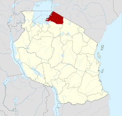 Location in Tanzania | |
| Country | Tanzania |
| Zone | Lake |
| Capital | Musoma |
| Government | |
| • Regional Commissioner | Adam Malima |
| Area | |
| • Total | 21,760 km2 (8,400 sq mi) |
| Population (2012) | |
| • Total | 1,743,830 |
| • Density | 80/km2 (210/sq mi) |
| Time zone | UTC+3 (EAT) |
| Postcode | 31xxx |
| Area code(s) | 028 |
| HDI (2018) | 0.522[1] low · 15th of 25 |
| Website | Regional website |
The neighboring regions are Mwanza Region and Simiyu Region (to the south), Arusha Region (to the southeast), and Kagera Region (across Lake Victoria). To the northeast, the Mara Region borders Narok County and Migori County in Kenya. The Mara Region is the home of Tanzania's first president, Julius Nyerere. The Mara Region was also the birthplace of Benga music.
Indigenous Groups
The Mara Region is the ancestral homeland to the following peoples:
- Luo
- Jita
- Ruri
- Zanaki,
- Kurya
- Kabwa
- Kiroba
- Simbiti
- Ngoreme
- Kwaya
- Nata
- Ikoma
- Isenye
- Ikizu
- Sizaki
- Sukuma
- Datooga
- Kine
- Hacha
- Surwa
Under occupying British rule, the Mara region was a district called the Lake Province, which became the Lake Region after independence in 1961.[3]
Geography and Environment
Location
The Mara region is located in the northern part of mainland Tanzania. It is located between latitudes 1° 0’ and 2° 31’ and between longitudes 33° 10’ and 35° 15’.[4] It contains 30,150 sq kilometers total, 10,584 sq kilometers of such being water area.[4] To the north the Mara region borders Uganda and Kenya.[4] It is also bordered by the Arusha region to its east, Shinyanga region to its south, as well as the Mwanza region in the southwest and west.[4] There are six administrative districts within the region: Musoma Rural, Musoma Urban, Bunda, Serengeti, Tarime and Rorya.
Climate
The maximum temperature of the region is 29.32℃ and minimum of 27.68℃, with an average of 28.50℃.[4] The Mara region experiences a bimodal rainfall pattern, consisting of two rainy seasons and two dry seasons.[5] The long rainfall period last between February until June.[4] The short rainfall period last between September and June.[4]
The Mara region can be divided into 3 climatic zones.[5] The northern zone resides in the Tarime district as well as parts of the Serengeti district.[5] On average, it receives annual rainfall of 1,250-2,000 mm/year.[5] The central zone includes much of Musoma district and eastern parts of Serengeti.[5] It receives an annual rainfall of 900–1300 mm/year.[5] The Lowland zone covers much of Bunda and the lake shores.[5] This zone receives 700–900 mm/year.[5]
Wildlife and Vegetation
The Mara region is mostly covered with natural vegetation, but there are large areas for cultivation.[5] The most prevalent landscape seen in the natural vegetation is the “savannah type” most commonly found in areas that receive annual rainfall between 900-1200 mms/year.[5] The Serengeti plains consist of savannah type vegetation with predominant forest vegetation, but mostly scattered woodlands and wooded grasslands.[5] The northern zone, receiving high annual rainfall, is composed of the humid forest.[5] The lowland zones with less annual rainfall consist of wooded grassland and bushland of dense thickets.[5]
14,750 sq kilometers of land is occupied by the Serengeti National Park.[5] It is located at the border of the Arusha and Mara Region.[5] It was established in 1951, and contains the vast and astonishing concentration of plain animals left anywhere in Africa.[5]
Lake Victoria
Lake Victoria borders the Mara Region of Tanzania.[6] The lake has a surface area 68,800 square km, and its coastline expands over 3,220 km.[6] It is the Nile's principle water reservoir.[6] Lake Victoria has numerous archipelagos, or groups of islands.[6] There are a plethora of over 200 species of fish, however economically Tilapia are important.[6]
National parks and monuments
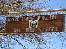
The Mara Region is home to the Serengeti National Park, one of the world's most famous national parks. Listed as a World Heritage Site, the national park occupies a large area of grasslands and woodlands and is home to a diverse range of wildlife. It attracts close to 150,000 tourists every year. The sanctuary is home to more than a million wildebeest, 200,000 zebras, and 300,000 Thomson's gazelles. Apart from conventional tourism in the park, there is also a range of ecotourism opportunities available in the Mara Region.[7]
Notable persons from Mara
- Julius Nyerere- the first president of both Tanganyika and Tanzania, attended Mwisenge Primary School in Musoma
- Joseph Warioba- Tanzania's sixth prime minister (1984-1985) and fourth vice president (1985-1990)
- Stephen Wassira- politician
- Maria Nyerere- Tanzania's first first lady
- Daniel Owino Misiani- Tanzanian musician (the founder of Benga music)
Academics:
- Ibrahim Juma- Tanzanian High Court judge
- Prof. Philemon Sarungi- Tanzania's first Orthopaedic Surgeon
Athletes:
- Dickson Marwa Mkami- Tanzanian long-distance runner
- Mbwana Samata- football athlete (Simba, TP Mazembe, and national team)
- Bitta John Musiba, football athlete( Simba and national team)
- Amri Kiemba- football athlete (Simba and national team)
- Elias Mfungo Sulus- Former President of the Tanzania Amateur Athletics Association ( TAAA) now known as AT, East Africa Athletics Federation and the First Tanzanian to become a Technical Committee member of the International Amateur Athletics Federation (IAAF)and former National Athletic Team in 1950s and 1960s.
Administrative divisions
Districts
The region is administratively divided into seven districts:
| Districts of Mara Region | ||||||
|---|---|---|---|---|---|---|
| Map | District | Population (2012) | ||||
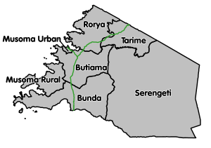 |
Bunda | 335,061 | ||||
| Butiama | 241,732 | |||||
| Musoma Rural | 178,356 | |||||
| Musoma Urban | 134,327 | |||||
| Rorya | 265,241 | |||||
| Serengeti | 249,420 | |||||
| Tarime | 339,693 | |||||
| Total | 1,743,830 | |||||
Constituencies
For parliamentary elections, Tanzania is divided into constituencies. As of the 2010 elections the Mara Region had seven constituencies:[8]
- Bunda Constituency and Mwibara Constituency in Bunda District.
- Musoma Mjini Constituency in Musoma Urban District,
- Musoma Vijijini Constituency in Musoma Rural District,
- Rorya Constituency in Rorya District
- Serengeti Constituency in Serengeti District
- Tarime Constituency in Tarime District
See also
References
- "Sub-national HDI - Area Database - Global Data Lab". hdi.globaldatalab.org. Retrieved 2020-02-26.
- Population Distribution by Administrative Units, United Republic of Tanzania, 2013 Archived 2013-06-12 at the Wayback Machine
- Ndembwike, John (2008). Life in Tanzania. Godfrey Mwakikagile. pp. 38–40.
- "International Science & Technology Practice & Policy".
- Tanzania., & Mara Regional Commissioner's Office. (2003). Mara Region: Socio-economic profile. Dar es Salaam: The Bureau.
- Encyclopedia Britannica, T. E. (2016, November 10). Lake Victoria. Retrieved from https://www.britannica.com/place/Lake-Victoria
- "Serengeti.org". Retrieved 16 January 2016.
- "Organisations located in Mara Region - Tanzania". African Development Information.