Tamborine, Queensland
Tamborine is a town in the Scenic Rim Region and a locality split between the Scenic Rim Region and the City of Logan in Queensland, Australia.[2][3][4] The neighbourhood of Plunkett is within the locality (27.8667°S 153.1500°E).[5]
| Tamborine Queensland | |||||||||||||||
|---|---|---|---|---|---|---|---|---|---|---|---|---|---|---|---|
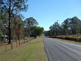 Greensward Road, 2014 | |||||||||||||||
| Population | 3,464 (2011 census)[1] | ||||||||||||||
| • Density | 42.87/km2 (111.04/sq mi) | ||||||||||||||
| Postcode(s) | 4270 | ||||||||||||||
| Area | 80.8 km2 (31.2 sq mi) | ||||||||||||||
| Location | 47 km (29 mi) south of Brisbane | ||||||||||||||
| LGA(s) | |||||||||||||||
| State electorate(s) | |||||||||||||||
| Federal Division(s) | Wright | ||||||||||||||
| |||||||||||||||
History
Yugembah (also known as Yugumbir, Jugambel, Jugambeir, Jugumbir, Jukam, Jukamba) is one of the Australian Aboriginal languages in areas that include the Beenleigh, Beaudesert, Gold Coast, Logan, Scenic Rim, Albert River, Coolangatta, Coomera, Logan River, Pimpama, Tamborine and Tweed River Valley, within the local government boundaries of the City of Gold Coast, City of Logan, Scenic Rim Region and the Tweed River Valley.[6]
Tamborine used to be spelled Tambourine. It was the administrative centre of the Shire of Tamborine (formerly the Shire of Tambourine).
St Patrick's Catholic Church was established in the early 1870s on the south bank of the Albert River on Michael Yores' property “Spiddle” near a swamp. Originally there was a cemetery near the church but due to flooding, it was decided to relocate the cemetery to land donated by Thomas Plunkett on Plunkett Road (27.8522°S 153.1290°E). In the 1960s the church was moved to the site of the former Tamborine railway station, where it was renovated and then dedicated in June 1966 by the Roman Catholic Archbishop of Brisbane Patrick Mary O'Donnell. As at 2020, a montlhy vigil service is held at the church.[7][8]
Tambourine Provisional School was instigated by Michael Yore and Thomas Plunkett. It was opened on 24 August 1874 in St Patrick's Catholic Church. In February 1905, the Queensland Government provided 10 acres (4.0 ha) for a permanent school building at 2680-2726 Waterford Tamborine Road (27.8767°S 153.1250°E).[9][10] On 1 January 1909 the school became Tambourine State School. The spelling was changed to Tamborine on 29 April 1926. In 1933 a larger teacher's residence was built.[11][12][13] Tamborine State School closed on 10 July 1970.[14][15] The teacher's residence was relocated to Tamrookum. The school building was relocated to Chambers Flat at the Beaudesert Shire Council's depot; it was subsequently relocated to Tamborine Village.[8] The site of the school is now the Tamborine School Park.[16]
The Canungra railway line from Logan Village railway station on the South Coast railway line to Canungra was opened on 2 July 1915.[17][18][19][20] There were two railway stations on the line within present day locality of Tamborine: Plunkett railway station (27.8486°S 153.14071°E) and Tamborine railway station (27.8796°S 153.1298°E).[21] The line closed on 1 June 1955.[19][22]
During World War II, the 32nd Infantry Division of the American Army established a camp initially called Camp Tamborine (but later called Camp Cable after deceased soldier Gerald O. Cable) at Tamborine in 1942.[23]
Formerly in the Shire of Beaudesert, Tamborine was split between Logan City and Scenic Rim Region following the local government amalgamations in March 2008.
In the 2011 census, Tamborine had a population of 3,464.[1]
Heritage listings
Tamborine has the following heritage-listed sites:
- 869 Mundoolun Connection Road: Tamborine House [24]
Amenities
The Scenic Rim Regional Council operates a mobile library service which visits the corner or Waterford-Tamborine Road & Beenleigh-Beaudesert Rd, opposite the Shell service station.[25]
References
- Australian Bureau of Statistics (31 October 2012). "Tamborine". 2011 Census QuickStats. Retrieved 6 May 2014.

- "Tamborine - town in Scenic Rim Region (entry 33231)". Queensland Place Names. Queensland Government. Retrieved 29 December 2017.
- "Tamborine - locality in Scenic Rim Region (entry 48266)". Queensland Place Names. Queensland Government. Retrieved 29 December 2017.
- "Tamborine - locality in City of Logan (entry 48976)". Queensland Place Names. Queensland Government. Retrieved 29 December 2017.
- "Plunkett - unbounded locality in the Scenic Rim Region (entry 39089)". Queensland Place Names. Queensland Government. Retrieved 2 April 2020.
-

- "St Patrick's, Tamborine". St Mary's Catholic Parish Beaudesert. Archived from the original on 2 April 2020. Retrieved 2 April 2020.
- "Tamborine History". Bearded Dragon Hotel. Archived from the original on 2 April 2020. Retrieved 2 April 2020.
- "Parish of Tamborine" (Map). Queensland Government. 1974. Archived from the original on 2 April 2020.
- "NORTH BRISBANE LICENSING COURT". The Brisbane Courier. Queensland, Australia. 16 February 1905. p. 8. Retrieved 3 April 2020 – via Trove.
- "STATE SCHOOLS". The Week. Queensland, Australia. 26 April 1933. p. 19. Retrieved 3 April 2020 – via Trove.
- "OUR DISTRICT". The Beaudesert Times. Queensland, Australia. 21 April 1933. p. 5. Retrieved 3 April 2020 – via Trove.
- "Tambourine". The Beaudesert Times. Queensland, Australia. 16 June 1933. p. 5. Retrieved 3 April 2020 – via Trove.
- "Agency ID6474, Tamborine State School". Queensland State Archives. Retrieved 13 May 2014.
- "Opening and closing dates of Queensland Schools". Queensland Government. Retrieved 13 May 2014.
- Google (2 April 2020). "Tamborine School Park" (Map). Google Maps. Google. Retrieved 2 April 2020.
- "SKETCHER". The Queenslander. Queensland, Australia. 25 November 1911. p. 15. Retrieved 2 April 2020 – via Trove.
- Kerr, John (1990). Triumph of narrow gauge : a history of Queensland Railways. Boolarong Publications. p. 224. ISBN 978-0-86439-102-5.
- "The Canungra Branch" Australian Railway History January 1993 pp12-19
- Quinlan, Howard; Newland, John (2000). Australian Railway Routes 1854 - 2000. Redfern: Australian Railway Historical Society. p. 38. ISBN 0909650497.
- "Tamborine" (Map). Queensland Government. 1954. Archived from the original on 2 April 2020.
- Quinlan, Howard; Newland, John (2000). Australian Railway Routes 1854 - 2000. Redfern: Australian Railway Historical Society. p. 38. ISBN 0909650497.
- "Camp Cable near Logan Village". Archived from the original on 13 August 2014. Retrieved 6 May 2014.
- "Local Heritage Register" (PDF). Scenic Rim Regional Council. Archived from the original (PDF) on 24 September 2015. Retrieved 9 February 2015.
- "Mobile Library" (PDF). Scenic Rim Regional Council. Archived from the original (PDF) on 30 January 2018. Retrieved 31 January 2018.
Further reading
- Logan Village State School (1975), Centenary souvenir booklet, Logan Village — includes information on Tamborine State School
External links
- "Tamborine and Tamborine Shire". Queensland Places. Centre for the Government of Queensland, University of Queensland.