Summit Camp
Summit Camp, also Summit Station, is a year-round research station on the apex of the Greenland Ice Sheet. Its coordinates are variable, since the ice is moving. The coordinates provided here are as of July 2009. The station is located 3,216 metres (10,551 ft) above sea level.[1] The population of the station is typically five in wintertime, and has a maximum of 38 in the summer. The station is operated by the American-based CH2M HILL Polar Services[2], with support from the United States' National Science Foundation.[3][4] A permit from the Danish Polar Center (Danish: Dansk Polarcenter) under the auspices of the Home Rule Government of Greenland (Greenlandic: Kalaallit Nunaanni Inatsisartut) is required to visit the station.

Geography
The station is located approximately 360 km from the east coast and 500 km from the west coast of Greenland at (Saattut, Uummannaq), and 200 km north-northeast of the historical ice sheet station Eismitte. The closest town is Ittoqqortoormiit, 460 km east-southeast of the station. The station however is not part of Sermersooq municipality, but falls within the bounds of the Northeast Greenland National Park.
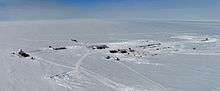
Summit Station consists of the Big House (communications and galley), Green House (science labs), Mobile Science Facility, Temporary Atmospheric Watch Observatory, Berthing Module, a combined garage and generator building, and storage buildings.[5]
History
Summit Station was originally established in April 1989 in support of the Greenland Ice Sheet Project Two (GISP2) deep ice coring effort. A ski-equipped C-130 from the New York Air National Guard performed an open snow landing near the site, bringing the put-in team consisting of Mark Twickler, Jay Klink, Michael Morrison, and two navigation specialists; Doug Roberts and Jim Normandeau who located the exact location chosen for the GISP2 drilling site, established a camp, and laid out the runway. Subsequent flights brought in additional materials and personnel needed to build the station. Two major structures were planned and built: The Big House, an insulated panel building (housing a galley, common space, and office), elevated to minimize snow drifts; and a geodesic drill dome to house the deep drill. Extensive under-snow trenches were also constructed to house the core handling, processing, and storage facilities. Many smaller Weatherport hut buildings and tents were also erected as storage and shop areas, as well as sleeping quarters. These were erected and taken down each season. On July 1, 1993, the bedrock was reached. Originally only occupied in the summer, the station has been staffed year-round since the early 2000s, with a winter population of 4 to 5.
Climate
The climate is classified as ice cap, with no month having a mean temperature exceeding 0°C. Typical daily maximum temperatures at Summit Camp are around −35 °C (−31 °F) in winter (January) and −10 °C (14 °F) in summer (July). Winter minimum temperatures are typically about −45 °C (−49 °F) and only rarely exceed −20 °C (−4 °F). The highest temperature at Summit Station was 2.2 °C (36.0 °F), recorded on 13 July 2012 and on 28 July 2017[6]; the lowest recorded temperature is −63.3 °C (−81.9 °F) on 21 February 2002. On July 6th 2017 the site recorded the lowest temperature in the northern hemisphere for the month of July at −33 °C (−27 °F).[7][8]
| Climate data for Automatic Weather Station (AWS), Summit Camp, Greenland Ice Sheet | |||||||||||||
|---|---|---|---|---|---|---|---|---|---|---|---|---|---|
| Month | Jan | Feb | Mar | Apr | May | Jun | Jul | Aug | Sep | Oct | Nov | Dec | Year |
| Record high °C (°F) | −11.7 (10.9) |
−11.0 (12.2) |
−12.8 (9.0) |
−1.2 (29.8) |
−1.4 (29.5) |
1.8 (35.2) |
2.2 (36.0) |
0.9 (33.6) |
−2.6 (27.3) |
−5.5 (22.1) |
−7.1 (19.2) |
−13.1 (8.4) |
2.2 (36.0) |
| Average high °C (°F) | −36 (−33) |
−38 (−36) |
−32 (−26) |
−29 (−20) |
−19 (−2) |
−11 (12) |
−11 (12) |
−14 (7) |
−22 (−8) |
−28 (−18) |
−28 (−18) |
−36 (−33) |
−25 (−14) |
| Daily mean °C (°F) | −43 (−45) |
−42 (−44) |
−41 (−42) |
−33 (−27) |
−23 (−9) |
−15 (5) |
−13 (9) |
−16 (3) |
−26 (−15) |
−34 (−29) |
−36 (−33) |
−40 (−40) |
−30 (−22) |
| Average low °C (°F) | −48 (−54) |
−46 (−51) |
−45 (−49) |
−40 (−40) |
−30 (−22) |
−19 (−2) |
−15 (5) |
−21 (−6) |
−29 (−20) |
−39 (−38) |
−42 (−44) |
−48 (−54) |
−35 (−31) |
| Record low °C (°F) | −61.2 (−78.2) |
−63.3 (−81.9) |
−61.2 (−78.2) |
−57.3 (−71.1) |
−47.4 (−53.3) |
−37.5 (−35.5) |
−33.0 (−27.4) |
−39.2 (−38.6) |
−46.0 (−50.8) |
−51.4 (−60.5) |
−60.0 (−76.0) |
−63.0 (−81.4) |
−63.3 (−81.9) |
| Source: [9][6] | |||||||||||||
Transport

During the summer months, the station is accessed via Kangerlussuaq Airport with LC-130 Hercules aircraft which land on a 4,572 by 60 m (15,000 by 197 ft) snow runway, which is prepared and regularly groomed for ski-equipped aircraft.[4] Winter access is infrequent, using smaller, ski-equipped aircraft such as a Twin Otter flown by Norlandair.
See also
References
- UNAVCO Archived 2008-08-28 at the Wayback Machine, UNAVCO Summit Station GPS Base Station
- CH2M HILL Polar Services
- Summit Camp
- Arctic Logistics Information And Support (ALIAS) Archived 2008-07-06 at the Wayback Machine
- Summit Camp virtual tour
- "Vejrekstremer Grønland". Danish Meteorological Institute (in Danish).
- Extreme Temperatures - "Extreme Temperatures Around the World". Retrieved January 15, 2013.
- Date of maximum temperature - "Record warmth at the top of the Greenland Ice Sheet". Weather Underground: Dr. Jeff Masters' Wunderblog. Retrieved January 15, 2013.
- Shuman, Christopher A.; Steffen, Konrad; Box, Jason E.; Stearns, Charles R. (2001). "A Dozen Years of Temperature Observations at the Summit: Central Greenland Automatic Weather Stations 1987–99". Journal of Applied Meteorology. American Meteorological Society. 40 (4): 741–752. doi:10.1175/1520-0450(2001)040<0741:adyoto>2.0.co;2. ISSN 0894-8763.