Milne Land
Milne Land or Milneland is a large island in eastern Greenland. It is the third largest island of Greenland, after the main island of Greenland and Disko Island. It is named after British admiral David Milne.
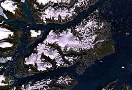 Milne Land seen from space | |
 Milne Land Milneland | |
| Geography | |
|---|---|
| Location | East-Greenland |
| Coordinates | 70°41′N 26°45′W |
| Major islands | Milne Land, Storø, Ujuaakajiip Nunaa, Bjørne Øer |
| Area | 3,913 km2 (1,511 sq mi) |
| Length | 100 km (60 mi)[1] |
| Width | 40 km (25 mi) |
| Highest elevation | 2,110 m (6,920 ft)[2] |
| Highest point | Unnamed |
| Administration | |
Greenland | |
| Province | Greenland |
| Municipality | Sermersooq |
| Demographics | |
| Population | 0 (2005) |
| Ethnic groups | none |
Geography
The island is 113 km (70 mi) long from Moraene Point in the southwest to Bregne Point in the northeast, and up to 45 km (28 mi), and 3,913 km2 (1,511 sq mi) in area. It is part of an archipelago, which includes Storo and Sorte Island in the Northwest, Denmark Island in the south, and the Bjorne Islands in the northeast. Cape Leslie is Milneland's southeastern headland.[4]
Milne Land is separated from the Renland peninsula in the north by the 6 to 10 km (6.2 mi) wide Ofjord, from the Gaaseland peninsula in the south by the 4 to 6 km (3.7 mi) wide Fonfjord, and from the mainland coast in the west by the 4 to 14 km (8.7 mi) wide Rode Fjord.
Jameson Land , the large peninsula in the east with the settlement of Ittoqqortoormiit on its southern coast, is located more than 40 km (25 mi) away across the Scoresby Sound.
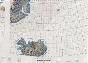 Map of NE Greenland and Iceland. |
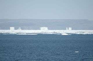 A superior mirage of sea ice and land near Milne Land. |
See also
- List of islands of Greenland
- Constable Point, the nearest airport.
- Liverpool Land
- Renland
- Scoresby Sound
References
- Scoresby Sund, Encyclopædia Britannica on-line
- Arctic DEM, Polar Geospatial Center
- Eventyr, Milne Land, Pt. 1,295m, North Pillar
- "Milne Land". Mapcarta. Retrieved 27 April 2016.