Peary Land
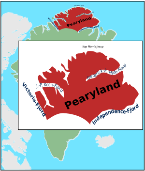
Peary Land is a peninsula in northern Greenland, extending into the Arctic Ocean. It reaches from Victoria Fjord in the west to Independence Fjord in the south and southeast, and to the Arctic Ocean in the north, with Cape Morris Jesup, the northernmost point of Greenland's mainland, and Cape Bridgman in the northeast.[1]
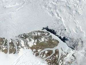 Satellite image of northern Peary Land including Cape Morris Jesup. | |
 Peary Land | |
| Geography | |
|---|---|
| Location | Northeast Greenland |
| Coordinates | 82°38′N 32°30′W |
| Adjacent bodies of water | Victoria Fjord |
| Length | 360 km (224 mi) |
| Width | 200 km (120 mi) |
| Highest elevation | 1,929 m (6,329 ft) |
| Highest point | Helvetia Tinde |
| Administration | |
Greenland (Denmark) | |
| Demographics | |
| Population | 0 |
History
Ancient settlements
Peary Land was historically inhabited by three separate cultures, during which times the climate was milder than presently:
- Independence I culture, Paleo-Eskimo (around 2000 BC, oldest remains dating from 2400 BC)
- Independence II culture, Paleo-Eskimo (800 BC to 200 BC)
- Thule culture (ancestral to the modern Inuit, around AD 1300)
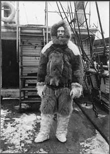
Peary's explorations
The area is named after Robert E. Peary, who first explored it during his expedition of 1891 to 1892. Originally, Peary Land was believed to be an island, separated from the main island by the Peary Channel, an assumed connection between Nordenskiöld Fjord and Independence Fjord.[2] Ludvig Mylius-Erichsen (1872-1907), the ill-fated leader of the Denmark expedition, searched in vain for the Peary Channel in 1907 and was misled to his death by existing maps.[3] Knud Rasmussen's First Thule Expedition confirmed in 1912 that Peary Land is a peninsula. There are more than 200 kilometers of dry land up to 1500 meters high between Nordenskiöld Fjord and Independence Fjord.
Research and mining
There are two Arctic research stations on Jørgen Brønlund Fjord, Brønlundhus (erected in 1948) and Kap Harald Moltke (erected in 1972). Both stations were built on initiative of Eigil Knuth, and have been the basis for many scientific expeditions. Kap Harald Moltke station was built later in connection with use of the natural runway east of Jørgen Brønlund Fjord mouth.[4] The stations located 10 km from each other on either side of the fjord, with Brønlundhus on the western side, and communication between them in summer is by boat, depending on ice conditions. Since the death of Eigil Knuth, the stations are administered by Peary Land Foundation. Today, Brønlundhus can be characterised as a museum, with a collection of artefacts from polar explorations.
In 1993 zinc and lead deposits were discovered in the Citronen Fjord.[5] They are deemed the largest yet unexploited zinc deposits in the world and the exploitation of the Citronen mine is in the preparation phase.[6] Important zinc and barium deposits have also been found at Navarana Fjord.[7]
Geography
Peary Land is bounded by the Lincoln Sea (west of Cape Morris Jesup) and Wandel Sea of the Arctic Ocean in the north. Oodaaq island, the northernmost point of land of the world, lies off the north coast. Frederick E. Hyde Fjord, which cuts into Peary Land from the east 150 km deep, divides it into Northern Peary Land and Southern Peary Land. The coastline is deeply indented by smaller fjords, such as G.B. Schley Fjord and Hellefisk Fjord in the east, and Sands Fjord, Benedict Fjord, J.P. Koch Fjord, De Long Fjord and Weyprecht Fjord in the west.
Peary Land is not part of any municipality, but belongs to the Northeast Greenland National Park. The size of the region is about 375 km east–west and 200 km north–south, with an estimated area of 57 000 km2. It is only a bit more than 700 km south of the North Pole.
Peary Land is not covered by an ice cap because the air is too dry to produce snow. Precipitation levels are so low (only about 25 to 200 mm per year) that most of its surface is polar desert. Located mostly north of the 82°N parallel, it contains the most northerly ice-free region of the world, mostly in Southern Peary Land (such as Melville Land and Herlufsholm Strand north of Independence Fjord). It was not covered by glaciers during the most recent ice age. However, in its western part, there is the Hans Tausen Ice Cap with ice at least 344 m thick.
Mountains
Peary Land is mountainous; the highest elevation is Helvetia Tinde reaching up to 1,929 m (6,329 ft) in the heavily glaciated and little-explored Roosevelt Range, the northernmost mountain range in the world.[8] 1,737 m (5,699 ft) high Wistar Bjerg,[9][10] 1,433 m (4,701 ft) high Stjernebannertinde, highest point of the H.H. Benedict Range —a subrange of the Roosevelt Range,[11] and 1,220 m (4,000 ft) high Nordkrone are other conspicuous high summits.
 Map of Far Northeastern Greenland. |
 Peary Land - location within Greenland |
Flora and fauna
Musk oxen and Peary Land collared lemmings are supported by the sparse vegetation, which covers only about 5% of the surface, mostly in the area around Jørgen Brønlund Fjord. Other fauna includes Arctic fox, polar wolf, polar bear, and Arctic hare. In former times there were also caribou, but the last live caribou reported from Northern Greenland were seen in Hall Land in 1922.[12]
The flora includes 33 species of flowering plants.
One to two million years ago, when climates were warmer, trees such as larch, black spruce, birch, yew, and thuja grew in northernmost Peary Land.
References
- "Frederick E. Hyde Fjord". Mapcarta. Retrieved 5 May 2016.
- Koch, L. (1925). "The Question of Peary Channel". Geographical Review. 15 (4): 643–649. doi:10.2307/208628. JSTOR 208628.
- G. Amdrup: Report on the Danmark Expedition to the North-East Coast of Greenland 1906–1908. In: Meddelelser om Grønland 41, 1913, pp. 1–270
- "Archived copy". Archived from the original on 2009-08-02. Retrieved 2009-08-02.CS1 maint: archived copy as title (link)
- Citronen Lead-Zinc Project
- Shipping from northern Greenlandic mine feasible, owner says
- Zinc potential at Navarana Fjord -Greenlands minerals authority
- Liviu Ivanescu, Arctic astronomy
- Den grønlandske Lods - Geodatastyrelsen
- Prostar Sailing Directions 2005 Greenland and Iceland Enroute, p. 130
- Geographical Items on North Greenland Encyclopedia Arctica, vol. 14
- Morten Meldgaard, Greenland Caribou - Zoogeography, Taxonomy, and Population Dynamics. P. 44