Stratford, New Jersey
Stratford is a borough in Camden County, New Jersey, United States. As of the 2010 United States Census, the borough's population was 7,040,[7][8][9] reflecting a decline of 231 (-3.2%) from the 7,271 counted in the 2000 Census, which had in turn declined by 343 (-4.5%) from the 7,614 counted in the 1990 Census.[18] The Rowan University School of Osteopathic Medicine is located in Stratford.
Stratford, New Jersey | |
|---|---|
| Borough of Stratford | |
 North Branch, Big Timber Creek | |
 Stratford highlighted in Camden County. Inset: Location of Camden County highlighted in the State of New Jersey. | |
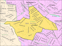 Census Bureau map of Stratford, New Jersey | |
 Stratford Location in Camden County 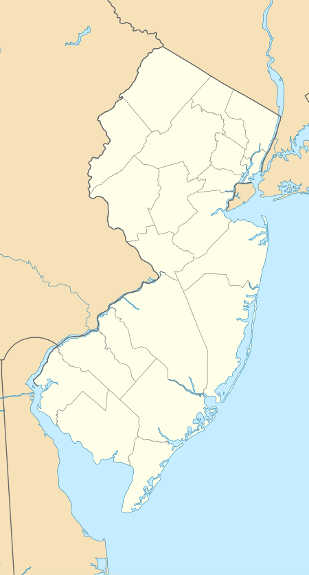 Stratford Location in New Jersey  Stratford Location in the United States | |
| Coordinates: 39.828957°N 75.015458°W[1][2] | |
| Country | |
| State | |
| County | Camden |
| Incorporated | February 13, 1925 |
| Named for | Stratford-upon-Avon, England |
| Government | |
| • Type | Borough |
| • Body | Borough Council |
| • Mayor | Josh Keenan (D, term ends December 31, 2023)[4] |
| • Administrator | Chris Conroy[5] |
| • Municipal clerk | Michaela Bosler (acting)[5] |
| Area | |
| • Total | 1.548 sq mi (4.010 km2) |
| • Land | 1.548 sq mi (4.010 km2) |
| • Water | 0.000 sq mi (0.000 km2) 0.00% |
| Area rank | 447th of 566 in state 23rd of 37 in county[1] |
| Elevation | 79 ft (24 m) |
| Population | |
| • Total | 7,040 |
| • Estimate (2019)[10] | 6,955 |
| • Rank | 318th of 566 in state 19th of 37 in county[11] |
| • Density | 4,547.0/sq mi (1,755.6/km2) |
| • Density rank | 124th of 566 in state 12th of 37 in county[11] |
| Time zone | UTC−05:00 (Eastern (EST)) |
| • Summer (DST) | UTC−04:00 (Eastern (EDT)) |
| ZIP Code | |
| Area code(s) | 856[14] |
| FIPS code | 3400771220[1][15][16] |
| GNIS feature ID | 0885411[1][17] |
| Website | www |
The Borough of Stratford was created on February 13, 1925, from portions of Clementon Township, one of seven municipalities created from the now-defunct township.[19] The borough was named for Stratford-upon-Avon, England, by the owners of the Rural Land Improvement Company that developed the area in the 1880s.[20][21]
Geography
According to the United States Census Bureau, the borough had a total area of 1.548 square miles (4.010 km2), all of which was land.[1][2]
The borough borders Gloucester Township (north and east), Hi-Nella (north), Laurel Springs (south), Lindenwold (south and west) and Somerdale (west).[22][23][24][25]
Demographics
| Historical population | |||
|---|---|---|---|
| Census | Pop. | %± | |
| 1930 | 958 | — | |
| 1940 | 980 | 2.3% | |
| 1950 | 1,356 | 38.4% | |
| 1960 | 4,308 | 217.7% | |
| 1970 | 9,801 | 127.5% | |
| 1980 | 8,005 | −18.3% | |
| 1990 | 7,614 | −4.9% | |
| 2000 | 7,271 | −4.5% | |
| 2010 | 7,040 | −3.2% | |
| Est. 2019 | 6,955 | [10][26][27] | −1.2% |
| Population sources: 1930-2000[28] 1930[29] 1930-1990[30] 2000[31][32] 2010[7][8][9] | |||
Census 2010
The 2010 United States Census counted 7,040 people, 2,641 households, and 1,822.290 families in the borough. The population density was 4,547.0 per square mile (1,755.6/km2). There were 2,761 housing units at an average density of 1,783.3 per square mile (688.5/km2). The racial makeup of the borough was 82.37% (5,799) White, 8.24% (580) Black or African American, 0.18% (13) Native American, 4.22% (297) Asian, 0.07% (5) Pacific Islander, 2.77% (195) from other races, and 2.14% (151) from two or more races. Hispanic or Latino of any race were 6.49% (457) of the population.[7]
The 2,641 households accounted 31.1% with children under the age of 18 living with them; 51.8% were married couples living together; 12.5% had a female householder with no husband present, and 31.0% were non-families. Of all households, 25.6% were made up of individuals, and 8.7% had someone living alone who was 65 years of age or older. The average household size was 2.64 and the average family size was 3.19.[7]
In the borough, the population age was spread out with 23.3% under the age of 18, 9.1% from 18 to 24, 26.5% from 25 to 44, 26.7% from 45 to 64, and 14.3% who were 65 years of age or older. The median age was 39.1 years. For every 100 females, the population had 95.8 males. For every 100 females ages 18 and older there were 92.9 males.[7]
The Census Bureau's 2006-2010 American Community Survey showed that (in 2010 inflation-adjusted dollars) median household income was $64,297 (with a margin of error of +/- $6,575) and the median family income was $86,375 (+/- $11,140). Males had a median income of $63,879 (+/- $4,823) versus $40,243 (+/- $1,924) for females. The per capita income for the borough was $32,383 (+/- $3,556). About 4.3% of families and 6.9% of the population were below the poverty line, including 9.4% of those under age 18 and 3.7% of those age 65 or over.[33]
Census 2000
As of the 2000 United States Census[15] there were 7,271 people, 2,736 households, and 1,906 families residing in the borough. The population density was 4,603.8 people per square mile (1,776.8/km2). There were 2,849 housing units at an average density of 1,803.9 per square mile (696.2/km2). The racial makeup of the borough was 88.56% White, 6.60% African American, 0.12% Native American, 2.38% Asian, 0.01% Pacific Islander, 0.87% from other races, and 1.46% from two or more races. Hispanic or Latino of any race were 3.81% of the population.[31][32]
There were 2,736 households, out of which 31.8% had children under the age of 18 living with them, 54.0% were married couples living together, 11.8% had a female householder with no husband present, and 30.3% were non-families. 25.8% of all households were made up of individuals, and 8.9% had someone living alone who was 65 years of age or older. The average household size was 2.61 and the average family size was 3.18.[31][32]
In the borough the population was spread out, with 24.7% under the age of 18, 8.1% from 18 to 24, 29.8% from 25 to 44, 21.6% from 45 to 64, and 15.8% who were 65 years of age or older. The median age was 38 years. For every 100 females, there were 95.1 males. For every 100 females age 18 and over, there were 89.3 males.[31][32]
The median income for a household in the borough was $50,977, and the median income for a family was $57,500. Males had a median income of $42,246 versus $29,153 for females. The per capita income for the borough was $21,748. About 2.5% of families and 4.6% of the population were below the poverty line, including 3.8% of those under age 18 and 4.4% of those age 65 or over.[31][32]
Government
Local government
Stratford is governed under the Borough form of New Jersey municipal government, which is used in 218 of 565 municipalities statewide, making it the most common form of government in New Jersey.[34] The governing body is comprised of a Mayor and a Borough Council, with all positions elected at-large on a partisan basis as part of the November general election. A Mayor is elected directly by the voters to a four-year term of office. The Borough Council is comprised of six members elected to serve three-year terms on a staggered basis, with two seats coming up for election each year in a three-year cycle.[3] The Borough form of government used by Stratford is a "weak mayor / strong council" government in which council members act as the legislative body with the mayor presiding at meetings and voting only in the event of a tie. The mayor can veto ordinances subject to an override by a two-thirds majority vote of the council. The mayor makes committee and liaison assignments for council members, and most appointments are made by the mayor with the advice and consent of the council.[35][36]
As of 2020, the Mayor of Stratford is Democrat Josh Keenan, whose term of office ends December 31, 2019.[37] Members of the Stratford Borough Council are Council President Tina Lomanno (D, 2022), Harry "Tom" Collins (D, 2020), Pat Gilligan (D, 2020), Patrick Green (D, 2021), Linda Hall (D, 2022) and Frank Hartman (D, 2021).[38][39][40][41][42]
Federal, state and county representation
Stratford is located in the 1st Congressional District[43] and is part of New Jersey's 6th state legislative district.[8][44][45] Prior to the 2011 reapportionment following the 2010 Census, Stratford had been in the 5th state legislative district.[46]
For the 116th United States Congress, New Jersey's First Congressional District is represented by Donald Norcross (D, Camden).[47][48] New Jersey is represented in the United States Senate by Democrats Cory Booker (Newark, term ends 2021)[49] and Bob Menendez (Paramus, term ends 2025).[50][51]
For the 2018–2019 session (Senate, General Assembly), the 6th Legislative District of the New Jersey Legislature is represented in the State Senate by James Beach (D, Voorhees Township) and in the General Assembly by Louis Greenwald (D, Voorhees Township) and Pamela Rosen Lampitt (D, Cherry Hill).[52][53]
Camden County is governed by a Board of Chosen Freeholders, whose seven members chosen at-large in partisan elections to three-year terms office on a staggered basis, with either two or three seats coming up for election each year.[54] As of 2018, Camden County's Freeholders are Freeholder Director Louis Cappelli Jr. (D, Collingswood, term as freeholder ends December 31, 2020; term as director ends 2018),[55] Freeholder Deputy Director Edward T. McDonnell (D, Pennsauken Township, term as freeholder ends 2019; term as deputy director ends 2018),[56] Susan Shin Angulo (D, Cherry Hill, 2018),[57] William F. Moen Jr. (D, Camden, 2018),[58] Jeffrey L. Nash (D, Cherry Hill, 2018),[59] Carmen Rodriguez (D, Merchantville, 2019)[60] and Jonathan L. Young Sr. (D, Berlin Township, 2020).[61][54]
Camden County's constitutional officers, all elected directly by voters, are County clerk Joseph Ripa (Voorhees Township, 2019),[62][63] Sheriff Gilbert "Whip" Wilson (Camden, 2018)[64][65] and Surrogate Michelle Gentek-Mayer (Gloucester Township, 2020).[66][67][68] The Camden County Prosecutor is Mary Eva Colalillo.[69][70]
Politics
As of March 23, 2011, there were a total of 4,606 registered voters in Stratford, of which 1,743 (37.8%) were registered as Democrats, 849 (18.4%) were registered as Republicans and 2,013 (43.7%) were registered as Unaffiliated. There was one voter registered to another party.[71]
In the 2012 presidential election, Democrat Barack Obama received 59.0% of the vote (1,911 cast), ahead of Republican Mitt Romney with 39.6% (1,282 votes), and other candidates with 1.5% (48 votes), among the 3,271 ballots cast by the borough's 4,925 registered voters (30 ballots were spoiled), for a turnout of 66.4%.[72][73] In the 2008 presidential election, Democrat Barack Obama received 56.8% of the vote (2,006 cast), ahead of Republican John McCain, who received around 39.9% (1,409 votes), with 3,534 ballots cast among the borough's 4,639 registered voters, for a turnout of 76.2%.[74] In the 2004 presidential election, Democrat John Kerry received 54.0% of the vote (1,886 ballots cast), outpolling Republican George W. Bush, who received around 44.3% (1,547 votes), with 3,492 ballots cast among the borough's 4,629 registered voters, for a turnout percentage of 75.4.[75]
In the 2013 gubernatorial election, Republican Chris Christie received 67.0% of the vote (1,340 cast), ahead of Democrat Barbara Buono with 31.4% (628 votes), and other candidates with 1.6% (32 votes), among the 2,056 ballots cast by the borough's 4,945 registered voters (56 ballots were spoiled), for a turnout of 41.6%.[76][77] In the 2009 gubernatorial election, Republican Chris Christie received 45.9% of the vote (1,005 ballots cast), ahead of both Democrat Jon Corzine with 45.1% (988 votes) and Independent Chris Daggett with 5.3% (116 votes), with 2,191 ballots cast among the borough's 4,630 registered voters, yielding a 47.3% turnout.[78]
Education
The Stratford School District serves public school students in pre-kindergarten through eighth grade. Students from Hi-Nella attend the district for PreK-8 as part of a sending/receiving relationship, under a five-year transition that started in 2012-13, bringing in an additional 100 students to the district.[79] Students from Laurel Springs also attend the district's schools for grades 7 and 8 as part of a sending/receiving relationship.[80] As of the 2018–19 school year, the district, comprised of two schools, had an enrollment of 862 students and 69.1 classroom teachers (on an FTE basis), for a student–teacher ratio of 12.5:1.[81] Schools in the district (with 2018–19 enrollment data from the National Center for Education Statistics[82]) are Parkview Elementary School[83] with 367 students in pre-kindergarten through third grade and Samuel S. Yellin Elementary School[84] with 487 students in grades 4 - 8.[85]
For ninth grade through twelfth grade, public school students attend Sterling High School, a regional high school district that also serves students from Magnolia and Somerdale, along with the sending districts of Hi-Nella and Laurel Springs.[86][87] The high school is located in Somerdale. As of the 2018–19 school year, the high school had an enrollment of 958 students and 69.8 classroom teachers (on an FTE basis), for a student–teacher ratio of 13.7:1.[88]
Stratford Classical Christian Academy serves students in Kindergarten through tenth grade.[89] John Paul II Regional School is an elementary school that operates under the auspices of the Roman Catholic Diocese of Camden, having opened for the 2008–09 school year as the result of the consolidation of area schools by the Camden diocese.[90][91]
The Rowan University School of Osteopathic Medicine has its campus on Laurel Road in Stratford Borough. It is made up of four buildings including the University Doctors' Pavilion and a Science Center.[92]
Rutgers University's Biomedical and Health Sciences school has a campus in Stratford.[93]
Transportation
_just_east_of_New_Road_in_Stratford%2C_Camden_County%2C_New_Jersey.jpg)
Roads and highways
As of May 2010, the borough had a total of 26.09 miles (41.99 km) of roadways, of which 21.77 miles (35.04 km) were maintained by the municipality, 3.21 miles (5.17 km) by Camden County and 1.11 miles (1.79 km) by the New Jersey Department of Transportation.[94]
U.S. Route 30 (White Horse Pike) runs from Laurel Springs in the borough's southeast corner and heads towards the northern tip of the borough along the border between Stratford to the southwest and Somerdale to the northeast before heading into Somerdale.[95]
Public transportation
NJ Transit bus service between Turnersville and Camden is available on the 403 route, with local service available on the 459 route operatining between Voorhees Town Center and the Avandale Park and Ride in Winslow Township.[96][97]
Notable people
People who were born in, residents of, or otherwise closely associated with Stratford include:
- Tamika Catchings (born 1979), professional basketball player who played in the WNBA for the Indiana Fever.[98]
- Mike Daniels (born 1989), defensive end for the Green Bay Packers.[99]
- Lee DeRamus (born 1972), wide receiver who played for two seasons in the NFL with the New Orleans Saints.[100]
- Ken Kelley (born 1960), American football linebacker who played two seasons in the United States Football League with the Philadelphia Stars, Chicago Blitz and Birmingham Stallions.[101]
- Brett Laxton (born 1973), former MLB pitcher who played in parts of two seasons for the Oakland Athletics and the Kansas City Royals.[102]
- Kelly Ripa (born 1970), actress and talk show host of Live! with Kelly.[103]
- Julian Talley (born 1989), NFL wide receiver for the New York Giants.[104]
References
- 2010 Census Gazetteer Files: New Jersey County Subdivisions, United States Census Bureau. Accessed May 21, 2015.
- US Gazetteer files: 2010, 2000, and 1990, United States Census Bureau. Accessed September 4, 2014.
- 2012 New Jersey Legislative District Data Book, Rutgers University Edward J. Bloustein School of Planning and Public Policy, March 2013, p. 28.
- 2020 New Jersey Mayors Directory, New Jersey Department of Community Affairs. Accessed February 1, 2020.
- Borough Staff, Borough of Stratford. Accessed March 13, 2020.
- U.S. Geological Survey Geographic Names Information System: Borough of Stratford, Geographic Names Information System. Accessed March 14, 2013.
- DP-1 - Profile of General Population and Housing Characteristics: 2010 for Stratford borough, Camden County, New Jersey Archived February 12, 2020, at Archive.today, United States Census Bureau. Accessed October 12, 2012.
- Municipalities Sorted by 2011-2020 Legislative District, New Jersey Department of State. Accessed February 1, 2020.
- Profile of General Demographic Characteristics: 2010 for Stratford borough Archived April 24, 2014, at the Wayback Machine, New Jersey Department of Labor and Workforce Development. Accessed October 12, 2012.
- QuickFacts for Stratford borough, New Jersey; Camden County, New Jersey; New Jersey from Population estimates, July 1, 2019, (V2019), United States Census Bureau. Accessed May 21, 2020.
- GCT-PH1 Population, Housing Units, Area, and Density: 2010 - State -- County Subdivision from the 2010 Census Summary File 1 for New Jersey Archived February 12, 2020, at Archive.today, United States Census Bureau. Accessed October 12, 2012.
- Look Up a ZIP Code for Stratford, NJ, United States Postal Service. Accessed October 12, 2012.
- Zip Codes, State of New Jersey. Accessed August 30, 2013.
- Area Code Lookup - NPA NXX for Stratford, NJ, Area-Codes.com. Accessed August 30, 2013.
- U.S. Census website , United States Census Bureau. Accessed September 4, 2014.
- Geographic Codes for New Jersey, Missouri Census Data Center. Accessed September 1, 2019.
- US Board on Geographic Names, United States Geological Survey. Accessed September 4, 2014.
- Table 7. Population for the Counties and Municipalities in New Jersey: 1990, 2000 and 2010, New Jersey Department of Labor and Workforce Development, February 2011. Accessed October 12, 2012.
- Snyder, John P. The Story of New Jersey's Civil Boundaries: 1606-1968, Bureau of Geology and Topography; Trenton, New Jersey; 1969. p. 108. Accessed October 12, 2012.
- Hutchinson, Viola L. The Origin of New Jersey Place Names, New Jersey Public Library Commission, May 1945. Accessed October 10, 2015.
- Index-analysis of the Statutes of New Jersey, Borough of Stratford. Accessed October 10, 2015. "In 1888 or 1889, Charles S. King saw the possibility of creating a pleasant and ideal He, along with Zimmerman, Twitchell, Smith and Rogers, formed the Rural Land Improvement Company. The development was roughly triangular in shape. The name they chose for this new community was Stratford--after Stratford-on-Avon in England."
- Home page, Borough of Stratford. Accessed October 12, 2012. "The Borough is bordered by the Borough of Hi-Nella on the north and Gloucester Township on the north and east, the Borough of Somerdale and the Borough of Lindenwold is to the west, and the Borough of Laurel Springs and the Borough of Lindenwold to the south."
- Areas touching Stratford, MapIt. Accessed March 13, 2020.
- Municipalities within Camden County, NJ, Delaware Valley Regional Planning Commission. Accessed March 13, 2020.
- New Jersey Municipal Boundaries, New Jersey Department of Transportation. Accessed November 15, 2019.
- Annual Estimates of the Resident Population for Minor Civil Divisions in New Jersey: April 1, 2010 to July 1, 2019, United States Census Bureau. Accessed May 21, 2020.
- Census Estimates for New Jersey April 1, 2010 to July 1, 2019, United States Census Bureau. Accessed May 21, 2020.
- Barnett, Bob. Population Data for Camden County Municipalities, 1850 - 2000, WestJersey.org, January 6, 2011. Accessed October 12, 2012.
- Fifteenth Census of the United States: 1930 - Population Volume I, United States Census Bureau, p. 715. Accessed October 12, 2012.
- Table 6. New Jersey Resident Population by Municipality: 1930 - 1990, New Jersey Department of Labor and Workforce Development. Accessed June 28, 2015.
- Census 2000 Profiles of Demographic / Social / Economic / Housing Characteristics for Stratford borough, New Jersey Archived July 8, 2007, at the Wayback Machine, United States Census Bureau. Accessed October 12, 2012.
- DP-1: Profile of General Demographic Characteristics: 2000 - Census 2000 Summary File 1 (SF 1) 100-Percent Data for Stratford borough, Camden County, New Jersey Archived February 12, 2020, at Archive.today, United States Census Bureau. Accessed October 12, 2012.
- DP03: Selected Economic Characteristics from the 2006-2010 American Community Survey 5-Year Estimates for Stratford borough, Camden County, New Jersey Archived February 12, 2020, at Archive.today, United States Census Bureau. Accessed October 12, 2012.
- Inventory of Municipal Forms of Government in New Jersey, Rutgers University Center for Government Studies, July 1, 2011. Accessed November 18, 2019.
- Cerra, Michael F. "Forms of Government: Everything You've Always Wanted to Know, But Were Afraid to Ask" Archived 2014-09-24 at the Wayback Machine, New Jersey State League of Municipalities. Accessed November 30, 2014.
- "Forms of Municipal Government in New Jersey", p. 6. Rutgers University Center for Government Studies. Accessed June 3, 2015.
- Mayor's Desk, Borough of Stratford. Accessed September 22, 2019.
- Council Members, Borough of Stratford. Accessed March 13, 2020.
- 2019 Municipal User Friendly Budget, Borough of Stratford. Accessed September 22, 2019.
- Official Election Results 2019 General Election November 5, 2019, Camden County, New Jersey, updated November 15, 2019. Accessed January 1, 2020.
- Official Election Results 2018 General Election November 6, 2018, Camden County, New Jersey, amended December 4, 2018. Accessed January 1, 2019.
- Official Election Results 2017 General Election November 7, 2017, Camden County, New Jersey, November 16, 2017. Accessed January 1, 2018.
- Plan Components Report, New Jersey Redistricting Commission, December 23, 2011. Accessed February 1, 2020.
- 2019 New Jersey Citizen's Guide to Government, New Jersey League of Women Voters. Accessed October 30, 2019.
- Districts by Number for 2011-2020, New Jersey Legislature. Accessed January 6, 2013.
- 2011 New Jersey Citizen's Guide to Government Archived June 4, 2013, at the Wayback Machine, p. 65, New Jersey League of Women Voters. Accessed May 22, 2015.
- Directory of Representatives: New Jersey, United States House of Representatives. Accessed January 3, 2019.
- Full Biography, Congressman Donald Norcross. Accessed January 3, 2019. "Donald and his wife Andrea live in Camden City and are the proud parents of three grown children and grandparents of two."
- About Cory Booker, United States Senate. Accessed January 26, 2015. "He now owns a home and lives in Newark's Central Ward community."
- Biography of Bob Menendez, United States Senate, January 26, 2015. "He currently lives in Paramus and has two children, Alicia and Robert."
- Senators of the 116th Congress from New Jersey. United States Senate. Accessed April 17, 2019. "Booker, Cory A. - (D - NJ) Class II; Menendez, Robert - (D - NJ) Class I"
- Legislative Roster 2018-2019 Session, New Jersey Legislature. Accessed January 22, 2018.
- District 6 Legislators, New Jersey Legislature. Accessed January 22, 2018.
- About the Freeholder Board, Camden County, New Jersey. Accessed June 6, 2018.
- Louis Cappelli Jr. , Camden County, New Jersey. Accessed June 6, 2018.
- Edward T. McDonnell, Camden County, New Jersey. Accessed June 6, 2018.
- Susan Shin Angulo, Camden County, New Jersey. Accessed June 6, 2018.
- William F. Moen Jr.l, Camden County, New Jersey. Accessed June 6, 2018.
- Jeffrey L. Nash, Camden County, New Jersey. Accessed June 6, 2018.
- Carmen Rodriguez, Camden County, New Jersey. Accessed June 6, 2018.
- Jonathan L. Young Sr., Camden County, New Jersey. Accessed June 6, 2018.
- County Clerk Joseph Ripa, Camden County, New Jersey. Accessed June 6, 2018.
- Members List: Clerks, Constitutional Officers Association of New Jersey. Accessed June 6, 2018.
- Sheriff Gilbert "Whip" Wilson, Camden County, New Jersey. Accessed June 6, 2018.
- Members List: Sheriffs, Constitutional Officers Association of New Jersey. Accessed June 6, 2018.
- Surrogate Michelle Gentek-Mayer, Camden County, New Jersey. Accessed June 6, 2018.
- Members List: Surrogates , Constitutional Officers Association of New Jersey. Accessed June 6, 2018.
- Your Government, Camden County, New Jersey. Accessed June 6, 2018.
- Prosecutor Mary Eva Colalillo, Camden County, New Jersey. Accessed June 6, 2018.
- Prosecutor's Bio, Office of the Camden County Prosecutor. Accessed June 6, 2018.
- Voter Registration Summary - Camden, New Jersey Department of State Division of Elections, March 23, 2011. Accessed October 15, 2012.
- "Presidential General Election Results - November 6, 2012 - Camden County" (PDF). New Jersey Department of Elections. March 15, 2013. Retrieved December 24, 2014.
- "Number of Registered Voters and Ballots Cast - November 6, 2012 - General Election Results - Camden County" (PDF). New Jersey Department of Elections. March 15, 2013. Retrieved December 24, 2014.
- 2008 Presidential General Election Results: Camden County, New Jersey Department of State Division of Elections, December 23, 2008. Accessed October 15, 2012.
- 2004 Presidential Election: Camden County, New Jersey Department of State Division of Elections, December 13, 2004. Accessed October 15, 2012.
- "Governor - Camden County" (PDF). New Jersey Department of Elections. January 29, 2014. Retrieved December 24, 2014.
- "Number of Registered Voters and Ballots Cast - November 5, 2013 - General Election Results - Camden County" (PDF). New Jersey Department of Elections. January 29, 2014. Retrieved December 24, 2014.
- 2009 Governor: Camden County Archived October 17, 2012, at the Wayback Machine, New Jersey Department of State Division of Elections, December 31, 2009. Accessed October 15, 2012.
- Borough of Stratford School District Comprehensive Annual Financial Report for the Fiscal Year Ended June 30, 2016, New Jersey Department of Education. Accessed February 5, 2017. "The addition of Hi-Nella students through a five-year phase-in send/receive agreement that began with the 2012-13 school year will increase total enrollment, at the end of the five years, by 100 students.... In addition, the School District provides educational services for students received on a tuition basis in grades 7 and 8 from the Laurel Springs School District and in grades Pre-K through 8 from the Hi-Nella School District."
- Samuel S. Yellin Elementary School 2016 Report Card Narrative, New Jersey Department of Education. Accessed August 5, 2017. "The Yellin School houses approximately 515 students that are comprised of five grade levels ranging from 4th Grade to 8th Grade. The nearby Laurel Springs School District is a sending district starting in 7th Grade."
- District information for Stratford School District, National Center for Education Statistics. Accessed April 1, 2020.
- School Data for the Stratford School District, National Center for Education Statistics. Accessed April 1, 2020.
- Parkview Elementary School, Stratford School District. Accessed May 4, 2020.
- Samuel S. Yellin Elementary School, Stratford School District. Accessed May 4, 2020.
- New Jersey School Directory for the Stratford School District, New Jersey Department of Education. Accessed December 29, 2016.
- Sterling High School 2015 Report Card Narrative, New Jersey Department of Education. Accessed June 2, 2016. "Sterling High School District is a regional district serving Hi Nella, Laurel Springs, Magnolia, Somerdale and Stratford. Sterling is a suburban residential community, approximately 7 miles southeast of Camden, NJ and part of the Philadelphia, PA metropolitan area."
- Comprehensive Annual Financial Report For the Fiscal Year Ended June 30, 2011, Sterling High School District. Accessed December 8, 2014. "The purpose of the School District is to provide educational services for resident students in grades 9 through 12 that reside in the Borough's of Magnolia, Somerdale and Stratford. In addition, the School District provides educational services for students in grades 9 through 12 received, on a tuition basis, from the Laurel Springs School District and the Hi-Nella School District."
- School data for Sterling High School, National Center for Education Statistics. Accessed April 1, 2020.
- Borough Profile, Borough of Stratford. Accessed October 12, 2012.
- Catholic Schools Directory, Roman Catholic Diocese of Camden. Accessed October 20, 2016.
- History, John Paul II Regional School. "September 2008 – John Paul II Regional School opened its doors."
- Fast Facts, Rowan University School of Osteopathic Medicine. Accessed July 1, 2013.
- http://rbhs.rutgers.edu/locations.shtml
- Camden County Mileage by Municipality and Jurisdiction, New Jersey Department of Transportation, May 2010. Accessed November 6, 2013.
- U.S. Route 30 Straight Line Diagram, New Jersey Department of Transportation, April 2008. Accessed November 6, 2013.
- Camden County Bus / Rail Connections, NJ Transit, backed up by the Internet Archive as of May 22, 2009. Accessed October 12, 2012.
- South Jersey Transit Guide Archived September 29, 2018, at the Wayback Machine, Cross County Connection, as of April 1, 2010. Accessed October 28, 2014.
- D'Alessandro, Dave. "D'Alessandro: Tamika Catchings becomes WNBA star by overcoming adversity", The Star-Ledger, September 17, 2011. Accessed November 6, 2013. "She didn't remember her first home — the tiny Jersey town of Stratford, outside Camden — but she was smart enough to know that this was home for as long as her parents said it was going to be, and that was that."
- Mike Daniels, Green Bay Packers. Accessed November 17, 2014. "Given name Michael Wayne Daniels Jr. …Born in Stratford, N.J."
- Lee DeRamus, National Football League. Accessed November 6, 2013.
- "Getting a Grip", The Philadelphia Inquirer, January 12, 1983. Accessed September 22, 2019. "'We have a lot of Penn State players going Ito the Stars, and it would be nice to play close to home,' said Kelley, whose family lives in Stratford, N.J."
- Brett Laxton, Baseball-Reference.com. Accessed October 10, 2015.
- Staff. "Philly Birthday Girl: Kelly Ripa", The Philadelphia Inquirer, September 26, 2011. Accessed November 6, 2013. "We already know there's nothing she can't do - host, mother, act, dance, sing (kinda), toss food miraculously into the right spots in her Electrolux kitchen - so we're hoping Stratford, N.J.-native and Eastern High School grad Kelly Ripa takes a breather on her birthday off-air on Sunday."
- Julian Talley Archived October 18, 2015, at the Wayback Machine, New York Giants. Accessed October 10, 2015. "Hometown: Stratford, NJ"
External links
| Wikimedia Commons has media related to Stratford, New Jersey. |
- Stratford Borough municipal website
- Stratford School District
- Stratford School District's 2015–16 School Report Card from the New Jersey Department of Education
- School Data for the Stratford School District, National Center for Education Statistics
- Sterling High School
- Stratford Athletic Organization
- Stratford Photos, News, Public Forum
- Sterling High School's 2015–16 School Performance Report from the New Jersey Department of Education
Municipalities and communities of Camden County, New Jersey, United States | ||
|---|---|---|
| Cities | 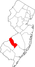 Map of New Jersey highlighting Camden County | |
| Boroughs | ||
| Townships | ||
| CDPs | ||
| Other unincorporated communities | ||
| Counties |  | |
|---|---|---|
| Major cities | ||
| Cities and towns 50k-99k | ||
| Cities and towns 30k-50k | ||
| Authority control |
|
|---|