Strafford, New Hampshire
Strafford is a town in Strafford County, New Hampshire, United States. The population was 3,991 at the 2010 census.[1] The two main settlements in town are Center Strafford and Bow Lake Village.
Strafford, New Hampshire | |
|---|---|
Town | |
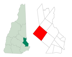 Location within Strafford County, New Hampshire | |
| Coordinates: 43°16′13″N 71°07′34″W | |
| Country | United States |
| State | New Hampshire |
| County | Strafford |
| Incorporated | 1820 |
| Villages | Bow Lake Village Center Strafford Strafford |
| Government | |
| • Board of selectmen | Lynn Sweet, Chair Scott Young Bryant Scott |
| • Town Administrator | Ellen White |
| Area | |
| • Total | 51.4 sq mi (33.2 km2) |
| • Land | 49.2 sq mi (127.3 km2) |
| • Water | 2.2 sq mi (5.8 km2) |
| Elevation | 595 ft (181 m) |
| Population (2010) | |
| • Total | 3,991 |
| • Density | 78/sq mi (120/km2) |
| Time zone | UTC-5 (EST) |
| • Summer (DST) | UTC-4 (EDT) |
| ZIP code | 03884 |
| Area code(s) | 603 |
| FIPS code | 33-73860 |
| GNIS feature ID | 0873726 |
| Website | strafford |
History
Once part of Barrington, Strafford was set off due to the lengthy travel required to attend town meetings. Settled prior to the Revolution, the town incorporated in 1820, taking its name from the county in which it is located. Strafford County had been organized in 1773 during the administration of Colonial Governor John Wentworth, and named in honor of Thomas Wentworth, Earl of Strafford.
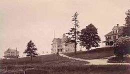
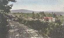
The Austin Academy once stood in the center of Strafford village. George Cate, a wealthy shoe manufacturer, visited the school at the request of its principal Alvin E. Thomas and was so impressed with the school that he left at his death $200,000 on the condition that his name be added to that of Mr. Austin. After his death, the hundred-acre farm of George Washington Foss was purchased and soon a beautiful new building, designed by well-known New Hampshire architect J. Edward Richardson, sat on the hill with the name on its facade, "Austin-Cate Academy - 1903". The property has been purchased by the state for a National Guard training center. The Foss farmhouse that was used as a dormitory burned in 1961 and was replaced with a one-story dormitory. The main building had burned in the early 1930s and was replaced with the brick building that is there now.[2]
Geography
According to the United States Census Bureau, the town has a total area of 51.4 square miles (133 km2), of which 49.2 sq mi (127 km2) is land and 2.2 sq mi (5.7 km2) is water, comprising 4.38% of the town. Bow Lake, popular with fishermen, covers 1,160 acres (470 ha). Strafford is drained by the Isinglass, Big, and Berrys rivers.
The Blue Hills Range divides the town in half, running southwest to northeast. Parker Mountain, the highest point in the range and in Strafford, rises to 1,420 feet (430 m) above sea level.
Adjacent municipalities
- Farmington (northeast)
- Rochester (east)
- Barrington (southeast)
- Northwood (southwest)
- Pittsfield (west)
- Barnstead (northwest)
Demographics
| Historical population | |||
|---|---|---|---|
| Census | Pop. | %± | |
| 1820 | 2,144 | — | |
| 1830 | 2,200 | 2.6% | |
| 1840 | 2,021 | −8.1% | |
| 1850 | 1,920 | −5.0% | |
| 1860 | 2,047 | 6.6% | |
| 1870 | 1,669 | −18.5% | |
| 1880 | 1,531 | −8.3% | |
| 1890 | 1,304 | −14.8% | |
| 1900 | 1,040 | −20.2% | |
| 1910 | 786 | −24.4% | |
| 1920 | 764 | −2.8% | |
| 1930 | 617 | −19.2% | |
| 1940 | 714 | 15.7% | |
| 1950 | 770 | 7.8% | |
| 1960 | 722 | −6.2% | |
| 1970 | 965 | 33.7% | |
| 1980 | 1,663 | 72.3% | |
| 1990 | 2,965 | 78.3% | |
| 2000 | 3,626 | 22.3% | |
| 2010 | 3,991 | 10.1% | |
| Est. 2017 | 4,114 | [3] | 3.1% |
| U.S. Decennial Census[4] | |||
As of the census[5] of 2000, there were 3,626 people, 1,281 households, and 1,022 families residing in the town. The population density was 73.7 people per square mile (28.5/km²). There were 1,564 housing units at an average density of 31.8 per square mile (12.3/km²). The racial makeup of the town was 98.48% White, 0.14% African American, 0.14% Native American, 0.25% Asian, 0.06% from other races, and 0.94% from two or more races. Hispanic or Latino of any race were 0.63% of the population.
There were 1,281 households out of which 43.2% had children under the age of 18 living with them, 68.5% were married couples living together, 8.2% had a female householder with no husband present, and 20.2% were non-families. 15.1% of all households were made up of individuals and 4.4% had someone living alone who was 65 years of age or older. The average household size was 2.82 and the average family size was 3.14.
In the town, the population was spread out with 30.0% under the age of 18, 4.8% from 18 to 24, 32.1% from 25 to 44, 25.4% from 45 to 64, and 7.7% who were 65 years of age or older. The median age was 37 years. For every 100 females, there were 100.1 males. For every 100 females age 18 and over, there were 95.1 males.
The median income for a household in the town was $59,044, and the median income for a family was $62,238. Males had a median income of $40,423 versus $30,524 for females. The per capita income for the town was $23,500. About 1.0% of families and 1.9% of the population were below the poverty line, including 1.5% of those under age 18 and 5.4% of those age 65 or over.
Notable person
- Charles Simic, fifteenth US Poet Laureate (2007–2008)
References
- United States Census Bureau, U.S. Census website, 2010 Census figures. Retrieved March 23, 2011.
- Strafford Town History
- "Annual Estimates of the Resident Population: April 1, 2010 to July 1, 2017 (PEPANNRES): Minor Civil Divisions – New Hampshire". Archived from the original on February 13, 2020. Retrieved November 15, 2018.
- "Census of Population and Housing". Census.gov. Retrieved June 4, 2016.
- "U.S. Census website". United States Census Bureau. Retrieved 2008-01-31.
External links
- Town of Strafford official website
- New Hampshire Economic and Labor Market Information Bureau Profile
Places adjacent to Strafford, New Hampshire | ||||||||||
|---|---|---|---|---|---|---|---|---|---|---|
| ||||||||||
Municipalities and communities of Strafford County, New Hampshire, United States | ||
|---|---|---|
| Cities | 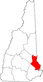 Map of New Hampshire highlighting Strafford County | |
| Towns | ||
| CDPs | ||
| Other villages | ||
| Authority control |
|
|---|