Santaquin, Utah
Santaquin (/ˈsæntəkwɪn/ SAN-tə-kwin) is a city in Utah and Juab counties in the U.S. state of Utah. It is part of the Provo–Orem metropolitan area. The population was 9,128 at the 2010 census[6] and an estimated 12,274 in 2018.[7]
Santaquin, Utah | |
|---|---|
 Old Santaquin Elementary School is now the Santaquin Chieftain Museum. | |
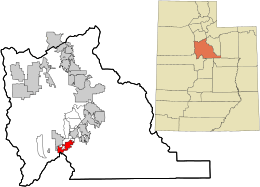 Location in Utah County and the state of Utah | |
| Coordinates: 39°58′29″N 111°47′4″W | |
| Country | United States |
| State | Utah |
| Counties | Utah, Juab |
| Settled | 1851 |
| Incorporated | 1890s (town) 1932 (city) |
| Named for | a Ute chief |
| Government | |
| • Mayor | Kirk Hunsaker |
| Area | |
| • Total | 10.44 sq mi (27.05 km2) |
| • Land | 10.44 sq mi (27.05 km2) |
| • Water | 0.00 sq mi (0.00 km2) |
| Elevation | 4,984 ft (1,519 m) |
| Population | |
| • Total | 9,128 |
| • Estimate (2018)[3] | 12,274 |
| • Density | 1,175.45/sq mi (453.83/km2) |
| Time zone | UTC-7 (Mountain (MST)) |
| • Summer (DST) | UTC-6 (MDT) |
| ZIP code | 84655 |
| Area code(s) | 385, 801 |
| FIPS code | 49-67770[4] |
| GNIS feature ID | 1445329[5] |
| Website | www |
Geography
Santaquin lies southeast of Utah Lake in southern Utah County, with a small portion extending south into Juab County. It is bordered to the northwest by Genola and to the north by unincorporated Spring Lake. Interstate 15 passes through the city, with access from Exits 242 and 244. I-15 leads north 21 miles (34 km) to Provo and south 19 miles (31 km) to Nephi. U.S. Route 6 passes through Santaquin as Main Street and leads west 24 miles (39 km) to Silver City. Utah State Route 198 leads north from I-15 5 miles (8 km) to Payson.
According to the United States Census Bureau, Santaquin has a total area of 10.4 square miles (26.9 km2), of which 0.3 acres (1,204 m2), or 0.01%, are water.[2]
Climate
This climatic region is typified by large seasonal temperature differences, with warm to hot (and often humid) summers and cold (sometimes severely cold) winters. According to the Köppen Climate Classification system, Santaquin has a humid continental climate, abbreviated "Dfb" on climate maps.[8]
History
Santaquin, one of the early settlements along the Salt Lake Road, was originally settled in late 1851. It was originally named Summit City because of its location near the summit of the divide between Utah Valley and Juab Valley. Summit City was settled by pioneers who were helping settle nearby Payson to the north. In 1856 it was renamed "Santaquin" for the son of Guffich, a local native chieftain friendly to the settlers.[9] Santaquin incorporated as a town in the 1890s and changed to a city effective January 4, 1932.
Demographics
| Historical population | |||
|---|---|---|---|
| Census | Pop. | %± | |
| 1860 | 158 | — | |
| 1870 | 602 | 281.0% | |
| 1880 | 715 | 18.8% | |
| 1890 | 769 | 7.6% | |
| 1900 | 889 | 15.6% | |
| 1910 | 915 | 2.9% | |
| 1920 | 976 | 6.7% | |
| 1930 | 1,115 | 14.2% | |
| 1940 | 1,297 | 16.3% | |
| 1950 | 1,214 | −6.4% | |
| 1960 | 1,183 | −2.6% | |
| 1970 | 1,236 | 4.5% | |
| 1980 | 2,175 | 76.0% | |
| 1990 | 2,386 | 9.7% | |
| 2000 | 4,834 | 102.6% | |
| 2010 | 9,128 | 88.8% | |
| Est. 2018 | 12,274 | [3] | 34.5% |
| U.S. Decennial Census[10] | |||
As of the census[4] of 2000, there were 4,834 people, 1,304 households, and 1,155 families residing in the city. The population density was 1,848.8 people per square mile (715.1/km²). There were 1,364 housing units at an average density of 521.7 per square mile (201.8/km²). The racial makeup of the city was 91.54% White, 0.17% African American, 0.62% Native American, 0.17% Asian, 0.06% Pacific Islander, 6.08% from other races, and 1.37% from two or more races. Hispanic or Latino of any race were 8.56% of the population.
There were 1,304 households out of which 61.1% had children under the age of 18 living with them, 77.8% were married couples living together, 7.5% had a female householder with no husband present, and 11.4% were non-families. 9.3% of all households were made up of individuals and 4.0% had someone living alone who was 65 years of age or older. The average household size was 3.71 and the average family size was 3.97.
In the city, the population was spread out with 42.3% under the age of 18, 11.3% from 18 to 24, 29.1% from 25 to 44, 12.4% from 45 to 64, and 4.9% who were 65 years of age or older. The median age was 23 years. For every 100 females, there were 105.3 males. For every 100 females age 18 and over, there were 99.6 males.
The median income for a household in the city was $44,531, and the median income for a family was $45,323. Males had a median income of $35,076 versus $20,581 for females. The per capita income for the city was $13,725. About 1.9% of families and 2.2% of the population were below the poverty line, including 1.6% of those under age 18 and 6.1% of those age 65 or over.
Main Street has a few stores and restaurants but no big-box stores.
Notable people
- Gary Coleman (1968–2010), actor[11]
Orchard Days
Orchard Days is a week-long celebration in late July and early August with a multitude of activities including a parade, rodeo, carnival, scavenger hunt, and several other family-friendly activities.
See also
- List of cities and towns in Utah
References
- "2018 U.S. Gazetteer Files". United States Census Bureau. Retrieved Feb 16, 2020.
- "Geographic Identifiers: 2010 Demographic Profile Data (G001): Santaquin city, Utah". U.S. Census Bureau, American Factfinder. Retrieved December 28, 2018.
- "Population and Housing Unit Estimates". Retrieved June 4, 2019.
- "U.S. Census website". United States Census Bureau. Retrieved 2008-01-31.
- "US Board on Geographic Names". United States Geological Survey. 2007-10-25. Retrieved 2008-01-31.
- Bureau, U.S. Census. "U.S. Census website". Retrieved 24 October 2016.
- "Population and Housing Unit Estimates". Retrieved August 18, 2019.
- "Santaquin, Utah Köppen Climate Classification (Weatherbase)". Retrieved 24 October 2016.
- Source: Myron V. Olson, compiler, "Give Me This Mountain, A History of the Santaquin Utah Stake," 1984 quoted in Santaquin History, accessed April 14, 2015.
- "Census of Population and Housing". Census.gov. Retrieved June 4, 2015.
- Hardy, Rodger L. (July 27, 2005). "Santaquin abuzz about new resident". Deseret News. Retrieved June 21, 2009.
External links
| Wikimedia Commons has media related to Santaquin, Utah. |
| Wikivoyage has a travel guide for Santaquin. |
Places adjacent to Santaquin, Utah | |
|---|---|
Municipalities and communities of Utah County, Utah, United States | ||
|---|---|---|
| Cities | 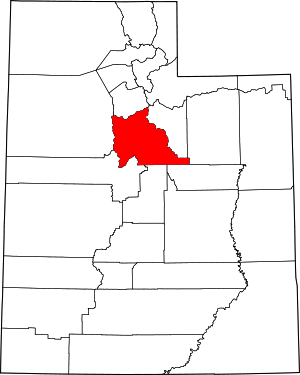 Map of Utah highlighting Utah County | |
| Towns | ||
| CDPs | ||
| Unincorporated communities | ||
| Indian reservation | ||
| Ghost towns | ||
| Footnotes | ‡This populated place also has portions in an adjacent county or counties | |
Municipalities and communities of Juab County, Utah, United States | ||
|---|---|---|
| Cities | 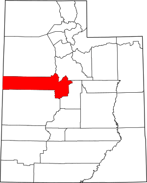 Map of Utah highlighting Juab County | |
| Towns | ||
| Unincorporated communities | ||
| Ghost towns |
| |
| Indian reservation | ||
| Footnotes | ‡This populated place also has portions in an adjacent county or counties | |
| Authority control |
|
|---|