South Central Timor Regency
South Central Timor Regency (Indonesian: Kabupaten Timor Tengah Selatan) is a regency in East Nusa Tenggara province of Indonesia. Established in 1958,[1] the regency has its seat (capital) in Soe.
South Central Timor Regency Kabupaten Timor Tengah Selatan | |
|---|---|
Regency | |
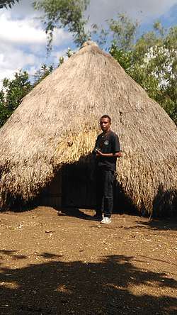 A rumah bulat ("round house") traditional house of South Central Timor | |
 Seal | |
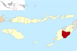 Location within East Nusa Tenggara | |
 South Central Timor Regency  South Central Timor Regency South Central Timor Regency (Lesser Sunda Islands)  South Central Timor Regency South Central Timor Regency (Indonesia) | |
| Coordinates: 9°28′18″S 124°48′17″E | |
| Country | |
| Region | Lesser Sunda Islands |
| Province | |
| Capital | Soe |
| Government | |
| • Regent | ir. Egusem Pieter Tahun, ST,MM |
| • Vice Regent | Johny Army Konay,SH |
| Area | |
| • Total | 1,524 sq mi (3,947 km2) |
| Population (2010 Census) | |
| • Total | 440,470 |
| • Density | 290/sq mi (110/km2) |
| Area code | (+62) 388 |
| Website | ttskab |
Mount Mutis, the highest mountain in the province of East Nusa Tenggara, is in the northern part of the regency. International visitors have noted that the region rich in bird life and that the area is a good site for birdwatching.[2]
The local economy in the area is poor and underdeveloped. Subsistence agriculture is the main economic activity in many villages. In addition, when opportunities are available, some local village communities sometimes undertake unregulated mining or other resource-based activities. For example, in the Kolbano Beach area south of Soe, there is a local industry in the collection of coloured stones. The stones, which come in a range of attractive shapes and sizes, are sold to local companies. The companies in turn export the stones to countries such as Australia, China, Malaysia, Singapore and elsewhere. Sacks of stones sell (mid-2012) for between Rp 10,000 to Rp 25,000 (about US$1.00 to US$2.50). Local villagers are reported to be able to earn around Rp 50,000 (US$5) per day collecting stones although there are complaints that the prices paid to workers who collect the stones are too low.[3]
However, there are concerns amongst some local community groups, such as the Molo people in the Mount Mutis Sanctuary, about the environmental impacts of mining in the area. There has been social resistance, for example, to the activities of mining firms conducting marble quarrying. Partly as a result of the local resistance, marble mining firms abandoned their work in the area in 2010.[4]
Administration
The regency is divided into 32 districts (kecamatan), tabulated below with their 2010 Census population.
| Name | English name | Population Census 2010 |
|---|---|---|
| Mollo Utara | North Mollo | 23,282 |
| Fatumnasi | 6,661 | |
| Tobu | 9,377 | |
| Nunbena | 5,078 | |
| Mollo Selatan | South Mollo | 15,122 |
| Polen | 13,668 | |
| Mollo Barat | West Mollo | 7,493 |
| Mollo Tengah | Central Mollo | 7,128 |
| Kota Soe | Soe Town | 39,285 |
| Amanuban Barat | West Amanuban | 21,752 |
| Batu Putih | 12,129 | |
| Kuatnana | 14,903 | |
| Amanuban Selatan | South Amanuban | 24,051 |
| Noebeba | 11,358 | |
| Kuan Fatu | 18,977 | |
| Kualin | 20,895 | |
| Amanuban Tengah | Central Amanuban | 15,172 |
| Kolbano | 18,476 | |
| Oenino | 10,533 | |
| Amanuban Timur | East Amanuban | 16,623 |
| Fautmolo | 7,256 | |
| Fatukopa | 4,996 | |
| Kie | 21,318 | |
| Kot'olin | 11,125 | |
| Amanatun Selatan | South Amanatun | 16,568 |
| Boking | 9,892 | |
| Nunkolo | 13,744 | |
| Noebana | 4,662 | |
| Santian | 6,477 | |
| Amanatun Utara | North Amanatun | 16,348 |
| Toianas | 12,382 | |
| Kokbaun | 3,163 | |
| Total | 440,470 |
References
- Government of Indonesia (9 August 1958), Establishment of the Second-level Administrative Regions under the First-level Administrative Region of Bali, West Nusa Tenggara and East Nusa Tenggara (in Indonesian), Indonesia Ministry of Law and Justice, UU No. 69/1958
- Neville Kemp, 'Bird-watching on Timor a rewarding experience' Archived 2013-05-20 at the Wayback Machine, The Jakarta Post, 3 May 2005.
- Yemris Foituna, 'East Nusa Tenggara: Farmers shift tactics to collecting stones', The Jakarta Post, 4 August 2012.
- Nani Afrida, 'Aleta Baun: Environmental heroine', The Jakarta Post, 18 April 2013.
Regencies and cities of East Nusa Tenggara | ||
|---|---|---|
Capital: Kupang | ||
| Regencies |  | |
| Cities | ||