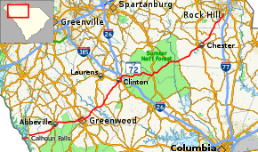
South Carolina Highway 72
South Carolina Highway 72 (SC 72) is a 125-mile (201 km) state highway, traversing interior portions of the South Carolina Piedmont region. The route connects many smaller communities outside major metropolitan areas and is roughly parallel with Interstate 85 (I-85) to the north and interstates 20 and 77 to the south and east. The route shares the longest concurrency in the state with SC 121, from Whitmire to Rock Hill.
| ||||
|---|---|---|---|---|
 | ||||
| Route information | ||||
| Maintained by SCDOT | ||||
| Length | 124.8 mi[1] (200.8 km) | |||
| Existed | 1942–present | |||
| Major junctions | ||||
| West end | ||||
| East end | ||||
| Location | ||||
| Counties | Abbeville, Greenwood, Laurens, Newberry, Union, Chester, York | |||
| Highway system | ||||
| ||||

Route description

The route travels across the state in a southwest to northeast direction, and is sometimes referenced as an unofficial border between the Midlands and the Upstate regions. Beginning at the Georgia state line on a bridge over Lake Russell (where it is the continuation of SR 72) SC 72 goes through the town of Calhoun Falls and goes through rural areas of Abbeville County before skirting the county seat of Abbeville on a bypass route. The route serves as the major thoroughfare for traffic between Abbeville and Greenwood, where it bypasses the downtown area to the north.
Leaving Greenwood, the route heads towards Clinton where it intersects with I-26. Passing the interstate, the route enters into the Sumter National Forest and passes through the small town of Whitmire. From Whitmire until just shy of its eastern terminus, SC 72 is cosigned with SC 121. The route exits the Sumter National Forest and bypasses Chester to the south. Once past Chester, the route turns more towards the north as it enters Rock Hill, where it terminates at SC 122 in the downtown area.
History
SC 72 had two previous stents in the state before settling in its current role. The first SC 72 was established in 1925 or 1926 as a new primary routing, from SC 7 at the Saluda River, north to SC 10 in Waterloo. In 1932, this routing became part of U.S. Route 221 (US 221).
The second SC 72 appeared in 1940 as a new primary routing from SC 7, near the Broad River, to Leeds. In 1942, it was renumbered as SC 722; though was later downgraded in 1948 to secondary Leeds Road (S-12-25).[2]
The third, and current, SC 72 was established in 1942 as a renumbering of SC 7; it traversed from the Georgia state line, near Calhoun Falls, to US 21 in Chester. In 1950, it was extended northeast to US 21/SC 5 in Rock Hill, which replaced part of US 21. In 1951 or 1952, its routing was adjusted west of Greenwood replacing SC 702 and leaving Old Abbeville Highway (S-1-3 and S-24-1).[3][4][5][6]
In 1954, SC 72 was placed on bypass south and east around Chester; its old alignment became a business route.[2][7] Also same year, SC 72 was moved south of Abbeville leaving behind Vienna Street (S-1-1) and Cambridge Street/Old Abbeville Highway (S-1-133).[3][4] In 1961, SC 72 was placed on new bypass north around Greenwood; its old alignment became a business route.[6][8] Sometime between 1990-1996, SC 72 was placed on a bypass south and east around Clinton; its old alignment became a business route.[9][10] In 2013, SC 72's eastern terminus was adjusted to end at the western terminus of SC 122 on Johnston Street; part of a major removal of highways through downtown Rock Hill.[11][12][13][14]
Junction list
| County | Location | mi[1] | km | Destinations | Notes |
|---|---|---|---|---|---|
| Abbeville | | 0.0 | 0.0 | Continuations beyond Georgia state line over the Savannah River/Richard B. Russell Lake | |
| Calhoun Falls | 3.2 | 5.1 | |||
| | 14.4 | 23.2 | |||
| | 16.0 | 25.7 | |||
| Abbeville | 18.0 | 29.0 | |||
| Greenwood | Greenwood | 27.8 | 44.7 | ||
| 28.7 | 46.2 | ||||
| 30.0 | 48.3 | North end of US 25 and west end of US 178 overlap | |||
| 30.7 | 49.4 | ||||
| 32.2 | 51.8 | South end of US 25/US 221 and east end of US 178 overlap | |||
| Coronaca | 37.1 | 59.7 | |||
| Laurens | | 40.5 | 65.2 | North end of US 221 overlap | |
| Cross Hill | 44.6 | 71.8 | |||
| Clinton | 56.4 | 90.8 | |||
| 56.7 | 91.2 | West end of SC 56 overlap | |||
| 58.1 | 93.5 | ||||
| 59.8 | 96.2 | East end of SC 56 overlap | |||
| 61.0 | 98.2 | I-26 exit 54 | |||
| Newberry | Whitmire | 75.7 | 121.8 | ||
| 76.0 | 122.3 | East end of US 176 and south end of SC 121 | |||
| Union | | 77.6 | 124.9 | West end of US 176 overlap | |
| Carlisle | 86.8 | 139.7 | North end of SC 215 overlap | ||
| Chester | | 90.7 | 146.0 | South end of SC 215 overlap | |
| Chester | 103.2 | 166.1 | North end of US 321/SC 9 overlap | ||
| 105.0 | 169.0 | South end of US 321/SC 97 overlap | |||
| 106.2 | 170.9 | South end of SC 9 overlap | |||
| 107.2 | 172.5 | North end of SC 97 overlap | |||
| Lewis | 112.5 | 181.1 | East end of SC 909 overlap | ||
| 112.6 | 181.2 | West end of SC 909 overlap | |||
| York | | 119.1 | 191.7 | ||
| Rock Hill | 123.2 | 198.3 | North end of SC 121 and south end of SC 901 overlap | ||
| 123.2 | 198.3 | North end of SC 901 overlap | |||
| 124.8 | 200.8 | ||||
1.000 mi = 1.609 km; 1.000 km = 0.621 mi
| |||||
Special routes
Greenwood business loop
| |
|---|---|
| Location | Greenwood, South Carolina |
| Length | 4.2 mi[15] (6.8 km) |
| Existed | 1961–present |
SC 72 Business was established in 1961 when mainline SC 72 was bypassed north of Greenwood. It follows the original mainline route through downtown Greenwood, via Cambridge Avenue, Grace Street and Reynolds Avenue.
Clinton business loop
| |
|---|---|
| Location | Clinton, South Carolina |
| Length | 3.3 mi[16] (5.3 km) |
SC 72 Business follows the original mainline route that use to traverse through downtown Clinton, via Broad Street and Willard Road. The route passes by the main entrance of Presbyterian College. It also shares a concurrency with SC 56 Bus. for the majority of the route.
Chester business loop
| |
|---|---|
| Location | Chester, South Carolina |
| Length | 2.6 mi[17] (4.2 km) |
| Existed | 1954–N/A |
SC 72 Business was established in 1954 when mainline SC 72 was bypassed to the south and east of Chester. It followed the original mainline route through downtown Chester, via West End Street, Main Street and Saluda Street/Road. In 1964, SC 121 Bus. was established and completely overlapped SC 72 Bus. It is unknown when the business loop was decommissioned.
Rock Hill business spur
| |
|---|---|
| Location | Rock Hill, South Carolina |
| Length | 1.8 mi[18] (2.9 km) |
| Existed | 1950–N/A |
SC 72 Business was established in 1950 as a business spur into downtown Rock Hill, via Saluda Street, from mainline SC 72, which continued east to terminate at US 21/SC5 (Anderson Road). Though never originally part of mainline SC 72, it was eventually replaced by the mainline at an unknown date.
References
- Google (April 8, 2014). "South Carolina Highway 72" (Map). Google Maps. Google. Retrieved April 8, 2014.
- General Highway Map, Chester County, South Carolina (PDF) (Map). Cartography by SCDOT. South Carolina Department of Transportation. 1942. Retrieved April 8, 2014.
- General Highway Map, Abbeville County, South Carolina (PDF) (Map). Cartography by SCDOT. South Carolina Department of Transportation. 1940. Retrieved April 8, 2014.
- General Highway Map, Abbeville County, South Carolina (PDF) (Map). Cartography by SCDOT. South Carolina Department of Transportation. 1958. Retrieved April 8, 2014.
- General Highway Map, Greenwood County, South Carolina (PDF) (Map). Cartography by SCDOT. South Carolina Department of Transportation. 1940. Retrieved April 8, 2014.
- General Highway Map, Greenwood County, South Carolina (PDF) (Map). Cartography by SCDOT. South Carolina Department of Transportation. 1950. Retrieved April 8, 2014.
- General Highway Map, Chester County, South Carolina (PDF) (Map). Cartography by SCDOT. South Carolina Department of Transportation. 1954. Retrieved April 8, 2014.
- General Highway Map, Greenwood County, South Carolina (PDF) (Map). Cartography by SCDOT. South Carolina Department of Transportation. 1963. Retrieved April 8, 2014.
- General Highway Map, Laurens County, South Carolina (PDF) (Map). Cartography by SCDOT. South Carolina Department of Transportation. 1987. Retrieved April 8, 2014.
- General Highway Map, Laurens County, South Carolina (PDF) (Map). Cartography by SCDOT. South Carolina Department of Transportation. 1996. Retrieved April 8, 2014.
- General Highway Map, York County, South Carolina (PDF) (Map). Cartography by SCDOT. South Carolina Department of Transportation. 1996. Retrieved April 8, 2014.
- "Binder-all applications May 2013" (PDF). AASHTO. May 2013. p. 301. Archived from the original (PDF) on October 19, 2013. Retrieved July 7, 2013.
- "Report to SCOH from USRN SM2013 May 3" (PDF). AASHTO. May 3, 2013. p. 8. Retrieved July 7, 2013.
- Rock Hill Urban Area, York County (PDF) (Map). South Carolina Department of Transportation. October 2013. Retrieved April 8, 2014.
- Google (September 1, 2013). "South Carolina Highway 72 Business - Greenwood" (Map). Google Maps. Google. Retrieved September 1, 2013.
- Google (September 1, 2013). "South Carolina Highway 72 Business - Clinton" (Map). Google Maps. Google. Retrieved September 1, 2013.
- Google (September 1, 2013). "South Carolina Highway 72 Business - Chester" (Map). Google Maps. Google. Retrieved September 1, 2013.
- Google (September 1, 2013). "South Carolina Highway 72 Business - Rock Hill" (Map). Google Maps. Google. Retrieved September 1, 2013.
External links

- Mapmikey's South Carolina Highways Page: SC 70-79