South Carolina Highway 56
South Carolina Highway 56 (SC 56) is a primary state highway in the state of South Carolina. The highway provides a back country alternative to Interstate 26 (I-26) from Clinton to Spartanburg.
| ||||
|---|---|---|---|---|
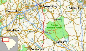 Route of SC 56 highlighted in red | ||||
| Route information | ||||
| Maintained by SCDOT | ||||
| Length | 63.3 mi[1] (101.9 km) | |||
| Existed | 1928–present | |||
| Major junctions | ||||
| West end | ||||
| East end | ||||
| Location | ||||
| Counties | Newberry, Laurens, Union, Spartanburg | |||
| Highway system | ||||
| ||||

Route description
SC 56 is generally a two-lane rural highway that expands to a four-lane urban highway in Clinton and Spartanburg. It travels 63.3 miles (101.9 km) in a north-south direction, though it is signed east-west; to make it more confusing, signage in Spartanburg reverse the directions. SC 56 has a roundabout interchange, known as Hearon Circle, with I-85 Business. In Clinton, signage that bypasses the downtown area use "TRUCK" instead of normal or bypass banners; though SC 56 Business is signed through the downtown area.[2]
History
SC 56 was established in 1928 as a new primary route from SC 392 (today SC 39) to U.S. Route 176 (US 176) in Pauline. In 1949, SC 56 was extended north, replacing US 176 to US 29 in Spartanburg. In 1959, SC 56 was extended north, replacing US 176 along Asheville Highway to its current terminus at US 176. Sometime after 1990, SC 56 was bypassed southeast of downtown Clinton, leaving a business loop.[3]
Junction list
| County | Location | mi[1] | km | Destinations | Notes | |||
|---|---|---|---|---|---|---|---|---|
| Newberry | | 0.0 | 0.0 | |||||
| | 8.3 | 13.4 | Belfast Road – Newberry | |||||
| Laurens | | 9.7 | 15.6 | |||||
| | 14.4 | 23.2 | ||||||
| Clinton | 18.7 | 30.1 | West end of SC 72 overlap | |||||
| 20.1 | 32.3 | |||||||
| 21.8 | 35.1 | East end of SC 72 overlap | ||||||
| 22.6 | 36.4 | |||||||
| 23.6 | 38.0 | I-26 exit 52. | ||||||
| Union |
No major junctions | |||||||
| Spartanburg | Cross Anchor | 33.5 | 53.9 | |||||
| | 33.9 | 54.6 | ||||||
| | 44.9 | 72.3 | ||||||
| Pauline | 47.7 | 76.8 | South end of SC 215 overlap | |||||
| | 48.7 | 78.4 | North end of SC 215 overlap | |||||
| Spartanburg | 54.6 | 87.9 | ||||||
| 57.8 | 93.0 | South end of US 221 overlap | ||||||
| 58.2 | 93.7 | |||||||
| 58.4 | 94.0 | |||||||
| 59.1 | 95.1 | North end of US 221 overlap | ||||||
| | 61.4 | 98.8 | Roundabout interchange | |||||
| | 63.3 | 101.9 | ||||||
1.000 mi = 1.609 km; 1.000 km = 0.621 mi
| ||||||||
Special routes
Clinton business loop
| |
|---|---|
| Location | Clinton, South Carolina |
| Length | 3.1 mi[4] (5.0 km) |
South Carolina Highway 56 Business traverses through downtown Clinton, in concurrency with SC 72 Business along Broad Street and Willard Road.[2]
References
- Google (February 8, 2013). "South Carolina Highway 56" (Map). Google Maps. Google. Retrieved February 8, 2013.
- Clinton City (PDF) (Map). South Carolina Department of Transportation. June 2010. Retrieved February 8, 2013.
- "Mapmikey's South Carolina Highways Page". Retrieved February 8, 2013.
- Google (February 8, 2013). "South Carolina Highway 56 Business - Loris" (Map). Google Maps. Google. Retrieved February 8, 2013.
External links
