Solebury Township, Bucks County, Pennsylvania
Solebury Township is a township in Bucks County, Pennsylvania, United States. The population was 8,692 at the 2010 census.
Solebury Township | |
|---|---|
 | |
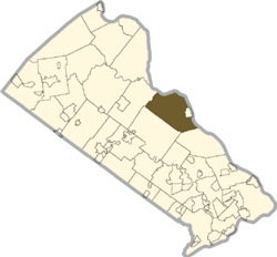 Location of Solebury Township in Bucks County | |
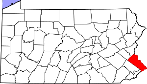
 Solebury Township Location in Pennsylvania and the United States  Solebury Township Solebury Township (the United States) | |
| Coordinates: 40°23′00″N 74°59′49″W | |
| Country | United States |
| State | Pennsylvania |
| County | Bucks |
| Area | |
| • Total | 27.15 sq mi (70.3 km2) |
| • Land | 26.57 sq mi (68.8 km2) |
| • Water | 0.58 sq mi (1.5 km2) |
| Elevation | 279 ft (85 m) |
| Population (2010) | |
| • Total | 8,692 |
| • Estimate (2016)[2] | 8,599 |
| • Density | 320/sq mi (120/km2) |
| Time zone | UTC-5 (EST) |
| • Summer (DST) | UTC-4 (EDT) |
| Area code(s) | 215, 267 and 445 |
| FIPS code | 42-017-71752 |
| Website | www |
History
Solebury has had history lining its borders since the 17th century, ever since the Europeans had settled in America. It contains historical sites that are visited every day by many. From the pre-revolutionary America to colonial times, and finally, the industrial revolution. Prior to the "Americans" taking over this town, it was owned by a Native American Tribe, the "Lenni-Lenape". This in English means, "original people". After the "Turtle Tribe" occupied this land it later became known as Solebury. In 1686 Solebury was finally signed over to the American settlers by 13 Native American tribe leaders.[3]
Abbie Hoffman committed suicide in 1989 in Solebury Township.
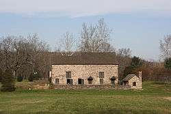
The Atkinson Road Bridge, Center Bridge Historic District, Cuttalossa Valley Historic District, George Nakashima House, Studio and Workshop, Isaiah Paxson Farm, Phillips Mill Historic District, J Henry Warren, Author, Red Fox Farm Long Valley Historic District, and Van Sant Covered Bridge are listed on the National Register of Historic Places.[4]
In July 2017 the remains of four young men were discovered on a farm along Rte 202. Cousins Cosmo DiNardo and Sean Kratz were charged with the murders.[5] DiNardo is serving life in prison for the murders.[6]
Geography
According to the United States Census Bureau, the township has a total area of 27.2 square miles (70.6 km²), of which 26.6 square miles (69.0 km²) is land and 0.6 square miles (1.6 km²) (2.20%) is water. It is drained by the Delaware River, which separates it from New Jersey. Past and present villages include Aquetong, Bowman Hill (also in Upper Makefield Township,) Carversville (also in Plumstead Township,) Center Bridge, Clayton, Cottageville, Fleecyville, Glendale, Highton (also in Buckingham Township,) Lahaska, Limeport, Lumberton, Lumberville, Naylors Corner, Peters Corners, Phillips Mill, Rosenthal, Ruckmans, Solebury, Stony Hill, Tooqueminsey, and Winnahawchunick.[7]
Natural features include Aquetong Creek, Aquetong Spring, Brun Bridle Hill and Forest, Canada Hill, Coppernose (hill), Cuttalossa Creek, Dark Hollow Run, Honey Hollow (valley), Kitchens Hill, Lahaska Creek, Little Buckingham Mountain, Paunacussing Creek, Phillips Creek, Pidcock Creek, Rabbit Run, and Solebury Mountain.[7]
Neighboring municipalities
- Upper Makefield Township (southeast)
- Buckingham Township (southwest)
- Plumstead Township (northwest)
- Kingwood Township, New Jersey (north)
- Delaware Township, Hunterdon County, New Jersey (northeast)
- Stockton, New Jersey (northeast)
- Lambertville, New Jersey (east)
- New Hope (east)
- West Amwell Township, New Jersey (east)
- Hopewell Township, Mercer County, New Jersey (east)
Climate
According to the Köppen climate classification system, Solebury Township, Pennsylvania has a hot-summer, wet all year, humid continental climate (Dfa). Dfa climates are characterized by at least one month having an average mean temperature ≤ 32.0 °F (≤ 0.0 °C), at least four months with an average mean temperature ≥ 50.0 °F (≥ 10.0 °C), at least one month with an average mean temperature ≥ 71.6 °F (≥ 22.0 °C), and no significant precipitation difference between seasons. During the summer months, episodes of extreme heat and humidity can occur with heat index values ≥ 100 °F (≥ 38 °C). On average, the wettest month of the year is July which corresponds with the annual peak in thunderstorm activity. During the winter months, episodes of extreme cold and wind can occur with wind chill values < 0 °F (< -18 °C). The plant hardiness zone is 6b with an average annual extreme minimum air temperature of -1.3 °F (-18.5 °C).[8] The average seasonal (Nov-Apr) snowfall total is between 30 and 36 inches (76 and 91 cm), and the average snowiest month is February which corresponds with the annual peak in nor'easter activity.
| Climate data for Solebury Township, Bucks County, Pennsylvania (1981 – 2010 averages) | |||||||||||||
|---|---|---|---|---|---|---|---|---|---|---|---|---|---|
| Month | Jan | Feb | Mar | Apr | May | Jun | Jul | Aug | Sep | Oct | Nov | Dec | Year |
| Average high °F (°C) | 38.9 (3.8) |
42.4 (5.8) |
50.7 (10.4) |
62.7 (17.1) |
72.7 (22.6) |
81.6 (27.6) |
85.9 (29.9) |
84.0 (28.9) |
77.1 (25.1) |
65.7 (18.7) |
54.7 (12.6) |
43.3 (6.3) |
63.4 (17.4) |
| Daily mean °F (°C) | 30.2 (−1.0) |
33.1 (0.6) |
40.6 (4.8) |
51.4 (10.8) |
61.2 (16.2) |
70.4 (21.3) |
75.0 (23.9) |
73.4 (23.0) |
66.1 (18.9) |
54.4 (12.4) |
44.8 (7.1) |
34.9 (1.6) |
53.1 (11.7) |
| Average low °F (°C) | 21.5 (−5.8) |
23.9 (−4.5) |
30.6 (−0.8) |
40.2 (4.6) |
49.6 (9.8) |
59.3 (15.2) |
64.2 (17.9) |
62.7 (17.1) |
55.1 (12.8) |
43.1 (6.2) |
34.9 (1.6) |
26.4 (−3.1) |
42.7 (5.9) |
| Average precipitation inches (mm) | 3.46 (88) |
2.75 (70) |
4.08 (104) |
4.07 (103) |
4.28 (109) |
4.50 (114) |
5.13 (130) |
4.01 (102) |
4.43 (113) |
4.08 (104) |
3.75 (95) |
4.12 (105) |
48.66 (1,236) |
| Average relative humidity (%) | 66.8 | 63.1 | 59.0 | 58.0 | 62.3 | 67.2 | 67.2 | 69.7 | 70.9 | 69.9 | 68.6 | 68.3 | 65.9 |
| Average dew point °F (°C) | 20.5 (−6.4) |
21.9 (−5.6) |
27.4 (−2.6) |
37.1 (2.8) |
48.2 (9.0) |
59.0 (15.0) |
63.4 (17.4) |
62.9 (17.2) |
56.4 (13.6) |
44.8 (7.1) |
35.1 (1.7) |
25.5 (−3.6) |
41.9 (5.5) |
| Source: PRISM Climate Group[9] | |||||||||||||
Ecology
According to the A. W. Kuchler U.S. potential natural vegetation types, Solebury Township, Pennsylvania would have an Appalachian Oak (104) vegetation type with an Eastern Hardwood Forest (25) vegetation form.[10]
Demographics
| Historical population | |||
|---|---|---|---|
| Census | Pop. | %± | |
| 1930 | 1,564 | — | |
| 1940 | 1,689 | 8.0% | |
| 1950 | 2,208 | 30.7% | |
| 1960 | 2,972 | 34.6% | |
| 1970 | 3,547 | 19.3% | |
| 1980 | 4,827 | 36.1% | |
| 1990 | 5,998 | 24.3% | |
| 2000 | 7,743 | 29.1% | |
| 2010 | 8,692 | 12.3% | |
| Est. 2016 | 8,599 | [2] | −1.1% |
| [11] | |||
As of the census[12] of 2000, there were 7,743 people, 3,053 households, and 2,170 families residing in the township. The population density was 290.6 people per square mile (112.2/km²). There were 3,207 housing units at an average density of 120.4/sq mi (46.5/km²).
The racial makeup of the township as of the 2010 census was:[13]
- 94.3% White
- 0.9% African American
- 0.0% Native American
- 2.9% Asian
- 0.1% Pacific Islander
- 1.1% from two or more races
- 2.7% Hispanic or Latino
There were 3,053 households:
- 30.4% contained children under the age of 18
- 63.9% were married couples living together
- 5.1% had a female householder with no husband present
- 28.9% were non-families.
- 19.0% of all households were made up of individuals
- 5.5% had someone living alone who was 65 years of age or older.
The average household size was 2.52 and the average family size was 2.94.
Solebury contained citizens of different ages
- 22.0% under the age of 18
- 4.1% from 18 to 24
- 25.8% from 25 to 44
- 36.5% from 45 to 64
- 11.6% who were 65 years of age or older.
The median age was 44 years. For every 100 females, there were 99.3 males. For every 100 females age 18 and over, there were 100.4 males.
The median income for a household in the township was $89,005, and the median income for a family was $103,566. Males had a median income of $71,176 versus $42,361 for females. The per capita income for the township was $52,985. About 1.7% of families and 3.1% of the population were below the poverty line, including 4.4% of those under age 18 and 3.5% of those age 65 or over.
Education
The Solebury School, a private co-educational day and boarding school, is located in the township.
Attractions
The New Hope-Lambertville Winter Festival takes place in Solebury yearly. Solebury contains a portion of the Washington Crossing Historic Park across the river from the larger Washington Crossing State Park.
The Bucks County Audubon Society at Honey Hollow maintains a nature preserve with six miles of hiking trails that are open to the public dawn to dusk every day for hiking and birdwatching.
Bowman’s Hill Wild Flower Preserve contains over 700 of Pennsylvania’s 2,000 native plant species grow naturally on 134 acres.
Notable people
- Peter H. Kostmayer, Congressman who lived in Solebury Township while in office[14]
- Jay Schulberg, advertising executive
- Dean Ween and Gene Ween of the American rock band Ween resided at an apartment on Van Sant Road in Solebury Township during the early 1990s, where they recorded their albums The Pod and Pure Guava.[15]
References
- "2016 U.S. Gazetteer Files". United States Census Bureau. Retrieved Aug 13, 2017.
- "Population and Housing Unit Estimates". Retrieved June 9, 2017.
- "Solebury Township: Parks & Recreation". Solebury Township, Pennsylvania. Archived from the original on 2011-07-19. Retrieved 2011-01-24.
- "National Register Information System". National Register of Historic Places. National Park Service. July 9, 2010.
- Eric Levenson and Steve Almasy. "Cousins charged in homicides of four Pennsylvania men". CNN. Retrieved 2017-07-15.
- Hogan, Alexandra (15 April 2019). "Sean Kratz in court ahead of trial in Bucks County murders case". WFMZ-TV 69. Retrieved 24 October 2019.
- MacReynolds, George, Place Names in Bucks County, Pennsylvania, Doylestown, Bucks County Historical Society, Doylestown, PA, 1942, P1.
- "USDA Interactive Plant Hardiness Map". United States Department of Agriculture. Retrieved 2019-06-27.
- "PRISM Climate Group, Oregon State U". www.prism.oregonstate.edu. Retrieved June 26, 2019.
- "U.S. Potential Natural Vegetation, Original Kuchler Types, v2.0 (Spatially Adjusted to Correct Geometric Distortions)". Data Basin. Retrieved 2019-07-31.
- (DVRPC), Delaware Valley Regional Planning Commission. "DVRPC > Site Search". www.dvrpc.org. Retrieved 10 May 2017.
- "U.S. Census website". United States Census Bureau. Retrieved 2008-01-31.
- https://www.usatoday.com/news/nation/census/profile/PA
- Barone, Michael; Ujifusa, Grant (1987). The Almanac of American Politics. National Journal. p. 1027.
- The Pod in New Hope
External links
| Wikimedia Commons has media related to Solebury Township, Bucks County, Pennsylvania. |
| Authority control |
|
|---|