Trevose, Pennsylvania
Trevose is a census-designated place within Lower Southampton Township,[4][5] while the entire community of Trevose within and beyond the CDP is in both Bensalem[6] and Lower Southampton Townships in Bucks County, Pennsylvania, United States, which is north of and borders northeastern Philadelphia.[2] Trevose was formerly part of Feasterville-Trevose, but was split into two separate CDPs for the 2010 census. U.S. 1 runs through the town as well as the Pennsylvania Turnpike, but Trevose's main road is Brownsville Road, which is the dividing line between the two townships. As of the 2010 census, Trevose had a population of 3,550.[7]
Trevose, Pennsylvania | |
|---|---|
 Intersection of Old Street Road and Brownsville Road | |
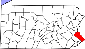
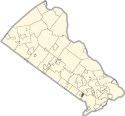 Location of Trevose in Bucks County | |
 Trevose Location of Trevose in Pennsylvania  Trevose Trevose (the United States) | |
| Coordinates: 40°08′21″N 74°58′52″W | |
| Country | United States |
| State | Pennsylvania |
| County | Bucks |
| Township | Bensalem, Lower Southampton |
| Area | |
| • Total | 0.706 sq mi (1.83 km2) |
| • Land | 0.706 sq mi (1.83 km2) |
| • Water | 0 sq mi (0 km2) |
| Elevation | 128 ft (39 m) |
| Population (2010) | |
| • Total | 3,550 |
| • Density | 5,000/sq mi (1,900/km2) |
| Time zone | UTC-5 (Eastern (EST)) |
| • Summer (DST) | UTC-4 (EDT) |
| ZIP code | 19053 |
| Area code(s) | 215, 267 and 445 |
| GNIS feature ID | 1189750[2] |
| Designated | October 29, 1946[3] |
The community is named after the home of settler Joseph Growden and itself after Growden's homestead in England (Growden was Cornish; Trevose is from the Cornish word Trenfos for farm.).[8]
Demographics
Racial Diversity As of the 2010 United States Census the population of Trevose, PA was 93.6% White, 1.9% African-American, 2.4% Asian, .2% American Indian or Alaska Native, .1% Native Hawaiian and Other Pacific Islander, and 1.2% Two or More Races. Approximately 3% of the population was Hispanic.[9]
Education Levels Trevose, PA has a very educated population with 5% of the population has received their Master’s Degree, 16% with a Bachelor’s Degree, 26% with some form of college or Associates Degree , 38% with a High School Diploma, and 14% of the population with less than a High School Deploma as of the 2010 Census
Gender and Age Trevose is 54% Female and 48% Male. 22% of the population is under 18, while 13% is over 65 years of age.
Income and Debt As of 2010, Trevose has a median household income of $82,413 and a median individual income of $34,943. Trevose’s unemployment rate is 6.5% and the poverty is very low at only 1%.
Climate
According to the Köppen climate classification system, Trevose has a Humid subtropical climate (Cfa). Cfa climates are characterized by all months having an average mean temperature > 32.0 °F (0.0 °C), at least four months with an average mean temperature ≥ 50.0 °F (10.0 °C), at least one month with an average mean temperature ≥ 71.6 °F (22.0 °C) and no significant precipitation difference between seasons. Although most summer days are slightly humid in Trevose, episodes of heat and high humidity can occur with heat index values > 107 °F (42 °C). Since 1981, the highest air temperature was 102.9 °F (39.4 °C) on July 22, 2011, and the highest average mean dew point was 76.5 °F (24.7 °C) on August 13, 1999. The average wettest month is July which corresponds with the annual peak in thunderstorm activity. Since 1981, the wettest calendar day was 6.73 inches (171 mm) on August 27, 2011. During the winter months, the average annual extreme minimum air temperature is 1.2 °F (−17.1 °C).[10] Since 1981, the coldest air temperature was −9.0 °F (−22.8 °C) on January 22, 1984. Episodes of extreme cold and wind can occur with wind chill values < −9 °F (−23 °C). The average annual snowfall (Nov-Apr) is 25.1 inches (64 cm). Ice storms and large snowstorms depositing ≥ 12 inches (30 cm) occur once every few years, particularly during nor’easters from December through February.
| Climate data for Trevose. Elevation: 154 ft (47 m), 1981–2010 normals, extremes 1981–2019 | |||||||||||||
|---|---|---|---|---|---|---|---|---|---|---|---|---|---|
| Month | Jan | Feb | Mar | Apr | May | Jun | Jul | Aug | Sep | Oct | Nov | Dec | Year |
| Record high °F (°C) | 71.7 (22.1) |
78.0 (25.6) |
87.2 (30.7) |
94.1 (34.5) |
95.3 (35.2) |
96.6 (35.9) |
102.9 (39.4) |
100.5 (38.1) |
98.3 (36.8) |
93.7 (34.3) |
81.3 (27.4) |
76.1 (24.5) |
102.9 (39.4) |
| Average high °F (°C) | 40.1 (4.5) |
43.3 (6.3) |
51.4 (10.8) |
63.2 (17.3) |
72.7 (22.6) |
81.9 (27.7) |
86.1 (30.1) |
84.5 (29.2) |
77.7 (25.4) |
66.4 (19.1) |
55.6 (13.1) |
44.4 (6.9) |
64.0 (17.8) |
| Daily mean °F (°C) | 32.1 (0.1) |
34.6 (1.4) |
42.0 (5.6) |
52.7 (11.5) |
62.1 (16.7) |
71.6 (22.0) |
76.2 (24.6) |
74.8 (23.8) |
67.6 (19.8) |
56.1 (13.4) |
46.4 (8.0) |
36.6 (2.6) |
54.5 (12.5) |
| Average low °F (°C) | 24.0 (−4.4) |
26.0 (−3.3) |
32.5 (0.3) |
42.1 (5.6) |
51.4 (10.8) |
61.3 (16.3) |
66.3 (19.1) |
65.0 (18.3) |
57.5 (14.2) |
45.8 (7.7) |
37.3 (2.9) |
28.7 (−1.8) |
44.9 (7.2) |
| Record low °F (°C) | −9.0 (−22.8) |
−1.9 (−18.8) |
4.5 (−15.3) |
18.2 (−7.7) |
34.2 (1.2) |
43.0 (6.1) |
49.3 (9.6) |
43.9 (6.6) |
37.2 (2.9) |
26.0 (−3.3) |
13.6 (−10.2) |
0.1 (−17.7) |
−9.0 (−22.8) |
| Average precipitation inches (mm) | 3.54 (90) |
2.73 (69) |
4.15 (105) |
3.97 (101) |
4.32 (110) |
4.32 (110) |
5.17 (131) |
4.39 (112) |
4.36 (111) |
3.74 (95) |
3.60 (91) |
3.96 (101) |
48.25 (1,226) |
| Average snowfall inches (cm) | 7.1 (18) |
8.8 (22) |
3.8 (9.7) |
0.7 (1.8) |
0.0 (0.0) |
0.0 (0.0) |
0.0 (0.0) |
0.0 (0.0) |
0.0 (0.0) |
0.0 (0.0) |
0.4 (1.0) |
4.3 (11) |
25.1 (64) |
| Average relative humidity (%) | 65.7 | 62.8 | 58.3 | 57.5 | 62.2 | 65.4 | 66.2 | 68.2 | 69.3 | 68.8 | 67.2 | 67.9 | 65.0 |
| Average dew point °F (°C) | 21.9 (−5.6) |
23.2 (−4.9) |
28.4 (−2.0) |
38.1 (3.4) |
49.0 (9.4) |
59.4 (15.2) |
64.1 (17.8) |
63.6 (17.6) |
57.2 (14.0) |
46.0 (7.8) |
36.1 (2.3) |
27.0 (−2.8) |
42.9 (6.1) |
| Source: PRISM[11] | |||||||||||||
Ecology
According to the A. W. Kuchler U.S. potential natural vegetation types, Trevose would have a dominant vegetation type of Appalachian Oak (104) with a dominant vegetation form of Eastern Hardwood Forest (25).[12] The plant hardiness zone is 7a with an average annual extreme minimum air temperature of 1.2 °F (−17.1 °C).[10] The spring bloom typically begins by April 7 and fall color usually peaks by November 4.
Notes
- "US Gazetteer files: 2010, 2000, and 1990". United States Census Bureau. 2011-02-12. Retrieved 2011-04-23.
- "Trevose, Pennsylvania". Geographic Names Information System. United States Geological Survey.
- "PHMC Historical Markers Search" (Searchable database). Pennsylvania Historical and Museum Commission. Commonwealth of Pennsylvania. Retrieved 2014-01-25.
- "Census - Geography Profile". United States Census Bureau. Retrieved 2019-10-31.
- "Census - Geography Profile". United States Census Bureau. Retrieved 2019-10-31.
- "Census - Geography Profile". United States Census Bureau. Retrieved 2019-10-31.
- "U.S. Census website". United States Census Bureau. Retrieved 2011-05-14.
- Thomson, Jonathan P.. (2011-07-13) The History of Bensalem: Part I (1670 - 1770) - Around Town - Bensalem, PA Patch. Bensalem.patch.com. Retrieved on 2013-07-21.
- "U.S. Census website". United States Census Bureau. Retrieved 2019-01-24.
- "USDA Interactive Plant Hardiness Map". United States Department of Agriculture. Retrieved September 30, 2019.
- "PRISM Climate Group, Oregon State University". Retrieved September 30, 2019.
- "U.S. Potential Natural Vegetation, Original Kuchler Types, v2.0 (Spatially Adjusted to Correct Geometric Distortions)". Retrieved September 30, 2019.