Solar eclipse of March 14, 1801
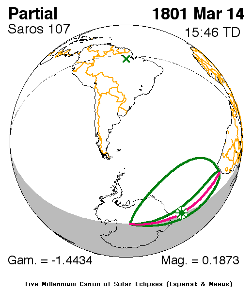
A partial solar eclipse occurred on March 14, 1801 just days before autumn (or fall). A solar eclipse occurs when the Moon passes between Earth and the Sun, thereby totally or partly obscuring the image of the Sun for a viewer on Earth. A partial solar eclipse occurs in the polar regions of the Earth when the center of the Moon's shadow misses the Earth.
| Solar eclipse of March 14, 1801 | |
|---|---|
 Map | |
| Type of eclipse | |
| Nature | Partial |
| Gamma | -1.4434 |
| Magnitude | 0.1873 |
| Maximum eclipse | |
| Coordinates | 61.2°S 40.6°E |
| Times (UTC) | |
| Greatest eclipse | 15:45:35 |
| References | |
| Saros | 107 (70 of 72) |
| Catalog # (SE5000) | 9042 |
It was the first of four partial eclipses that took place that year, each two in two months, the next on was on April 13 covered a part of the Northern Hemisphere.[1] It was the last three of solar saros 107, the next two were on March 25, 1819 and April 5, 1837.[2]
The eclipse was visible in Southern Ocean and Antarctica particularly the middle part of the north and around the South Pole.
The eclipse started at sunrise just close to the South Pole, the planet's southernmost point and finished at sunset not far from the Cape Colony, at the time a Dutch possession occupied by the French as part of the Napoleonic Wars (now divided into Southern and Northern Cape which are part of South Africa).
It showed about up to 25-30% obscurity in Antarctica. The greatest eclipse was hundreds of miles (or kilometers) offshore Antarctic Peninsula at 61.2 S, 40.6 EW at 15:45:35 UTC (6:13 PM local time).[1]
The subsolar marking was in Brazil inside the Amazon Rainforest around the Amazon River.
See also
- List of solar eclipses in the 19th century
- List of solar eclipses visible from Antarctica
References
- "Solar eclipse of March 14, 1801". NASA. Retrieved March 11, 2017.
- "Solar Saros 117". NASA. Retrieved March 12, 2017.
External links
.jpg)
